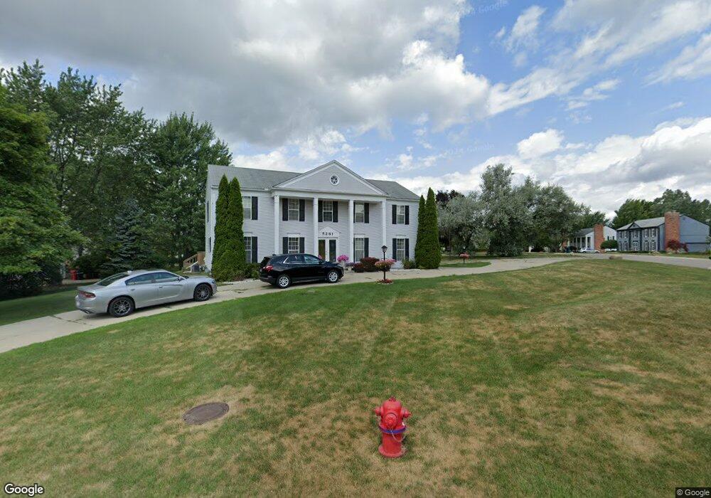
5261 Kingsfield Dr West Bloomfield, MI 48322
Estimated Value: $433,167 - $464,000
4
Beds
3
Baths
2,594
Sq Ft
$173/Sq Ft
Est. Value
About This Home
This home is located at 5261 Kingsfield Dr, West Bloomfield, MI 48322 and is currently estimated at $449,542, approximately $173 per square foot. 5261 Kingsfield Dr is a home located in Oakland County with nearby schools including Sheiko Elementary School, West Bloomfield Middle School, and Bloomfield Maples Montessori.
Ownership History
Date
Name
Owned For
Owner Type
Purchase Details
Closed on
Aug 29, 2013
Sold by
Rokes Jarbou and Jarbou Souad
Bought by
Salman Waleed Y
Current Estimated Value
Home Financials for this Owner
Home Financials are based on the most recent Mortgage that was taken out on this home.
Original Mortgage
$169,750
Outstanding Balance
$126,573
Interest Rate
4.38%
Mortgage Type
New Conventional
Estimated Equity
$322,969
Purchase Details
Closed on
Mar 2, 2010
Sold by
Ban Salman Khalid and Ban Salman
Bought by
Us Bank Na Nd
Purchase Details
Closed on
Mar 7, 1996
Sold by
Lepage Marguerite Gauld
Bought by
Petros Sabah
Home Financials for this Owner
Home Financials are based on the most recent Mortgage that was taken out on this home.
Original Mortgage
$130,000
Interest Rate
6.98%
Create a Home Valuation Report for This Property
The Home Valuation Report is an in-depth analysis detailing your home's value as well as a comparison with similar homes in the area
Home Values in the Area
Average Home Value in this Area
Purchase History
| Date | Buyer | Sale Price | Title Company |
|---|---|---|---|
| Salman Waleed Y | $175,000 | None Available | |
| Us Bank Na Nd | $159,200 | None Available | |
| Petros Sabah | $184,000 | -- |
Source: Public Records
Mortgage History
| Date | Status | Borrower | Loan Amount |
|---|---|---|---|
| Open | Salman Waleed Y | $169,750 | |
| Previous Owner | Petros Sabah | $130,000 |
Source: Public Records
Tax History Compared to Growth
Tax History
| Year | Tax Paid | Tax Assessment Tax Assessment Total Assessment is a certain percentage of the fair market value that is determined by local assessors to be the total taxable value of land and additions on the property. | Land | Improvement |
|---|---|---|---|---|
| 2024 | $2,856 | $178,450 | $0 | $0 |
| 2022 | $2,734 | $156,580 | $45,000 | $111,580 |
| 2021 | $4,155 | $145,040 | $0 | $0 |
| 2020 | $2,680 | $142,240 | $40,550 | $101,690 |
| 2018 | $4,276 | $128,130 | $28,700 | $99,430 |
| 2015 | -- | $106,090 | $0 | $0 |
| 2014 | -- | $96,330 | $0 | $0 |
| 2011 | -- | $84,630 | $0 | $0 |
Source: Public Records
Map
Nearby Homes
- 6265 Potomac Cir
- 5353 Wright Way W
- 5015 Langlewood Dr
- 5106 Rock Run
- 5216 Brett Ct Unit 53
- 6323 Potomac Cir Unit 22
- 5023 Meadowbrook Dr
- 5720 Beauchamp
- 5727 Royal Wood
- 5016 Patrick Rd
- 5428 Hammersmith Dr
- 6067 Charles Dr
- 6121 Westbrooke Dr Unit 7
- 6607 Westbrooke Ct
- 6684 Stonebridge E
- 5426 N Piccadilly
- 6783 Burtonwood Dr
- 5965 Crestwood Dr
- 5959 Bella Vista Dr
- 4800 Faircourt Dr
- 5275 Kingsfield Dr
- 5274 Langlewood Dr
- 5239 Kingsfield Dr
- 5267 Langlewood Dr
- 5291 Kingsfield Dr
- 5276 Kingsfield Dr
- 5310 Fox Ridge Dr
- 5326 Fox Ridge Dr
- 5240 Kingsfield Dr
- 5275 Langlewood Dr
- 5290 Kingsfield Dr
- 5285 Langlewood Dr
- 5305 Kingsfield Dr Unit Bldg-Unit
- 5305 Kingsfield Dr
- 5215 Forestdale Ct
- 5221 Forestdale Ct
- 5340 Fox Ridge Dr
- 5209 Cedarhurst Dr
- 5232 Kingsfield Dr
- 5225 Cedarhurst Dr