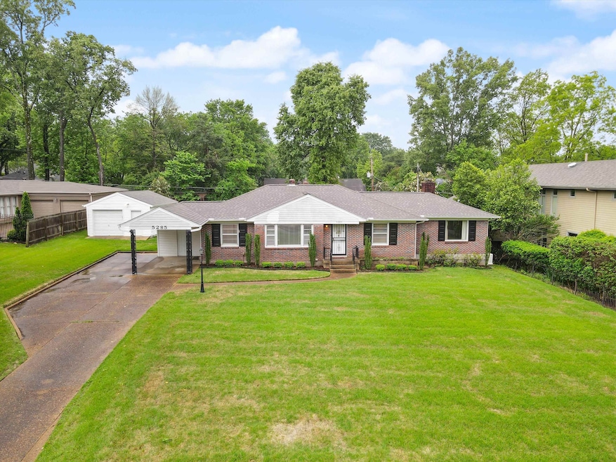
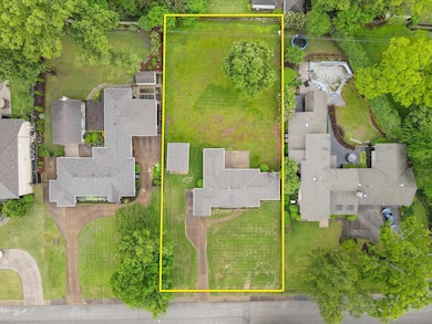
5285 Normandy Rd Memphis, TN 38120
East Memphis NeighborhoodEstimated payment $2,604/month
Highlights
- 0.62 Acre Lot
- Landscaped Professionally
- Wood Flooring
- Richland Elementary School Rated 9+
- Traditional Architecture
- Attic
About This Home
OPPORTUNITY! Great East Memphis Location with a chance to purchase a 3BR/ 2BA home on a rare, coveted .62-acre lot (108x254). Renovate to your liking, or perfect for a teardown to build your dream home. There are many million-dollar-plus homes in the area. The house is very livable as is, so there are multiple options. All buyers looking for future expansion, fantastic location, and to build extremely fast equity, take a look. HOME BUILDERS, this is also for you, a great option to build a new home! There will be a lease purchase option available as well. Photos to be updated and more added by end of day 10/25/2025.
Home Details
Home Type
- Single Family
Year Built
- Built in 1956
Lot Details
- 27,007 Sq Ft Lot
- Lot Dimensions are 108x254
- Wood Fence
- Landscaped Professionally
- Level Lot
Home Design
- Traditional Architecture
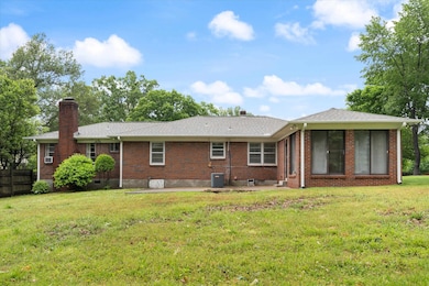
- Brick Veneer
- Slab Foundation
- Composition Shingle Roof
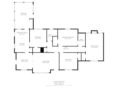
Interior Spaces
- 2,013 Sq Ft Home
- 1-Story Property
- Smooth Ceilings
- Ceiling Fan
- Fireplace Features Masonry
- Some Wood Windows
- Double Pane Windows
- Aluminum Window Frames
- Separate Formal Living Room
- Dining Room
- Den with Fireplace
- Sun or Florida Room
- Storage Room
- Laundry closet
Kitchen
- Eat-In Kitchen
- Oven or Range
- Dishwasher
- Disposal
Flooring
- Wood
- Brick
- Tile
Bedrooms and Bathrooms
- 3 Main Level Bedrooms
- Walk-In Closet
- 2 Full Bathrooms
Attic
- Attic Access Panel
- Pull Down Stairs to Attic
Home Security
- Fire and Smoke Detector
- Iron Doors
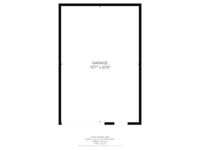
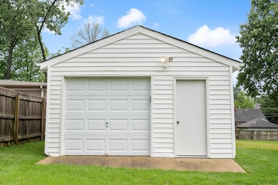
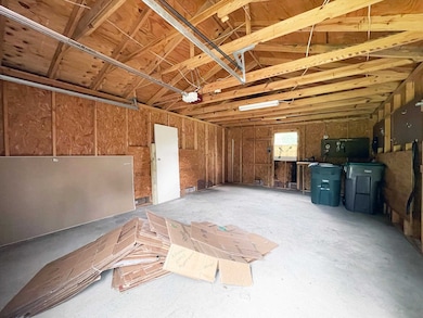
Parking
- 3 Car Garage
- Front Facing Garage
- Driveway
Utilities
- Central Heating and Cooling System
- Heating System Uses Gas
- 220 Volts
- Gas Water Heater
- Cable TV Available
Community Details
- Westview Land Co Richland Subdivision
Listing and Financial Details
- Assessor Parcel Number 068021 00003
Map
Home Values in the Area
Average Home Value in this Area
Tax History
| Year | Tax Paid | Tax Assessment Tax Assessment Total Assessment is a certain percentage of the fair market value that is determined by local assessors to be the total taxable value of land and additions on the property. | Land | Improvement |
|---|---|---|---|---|
| 2025 | $2,159 | $92,700 | $39,550 | $53,150 |
| 2024 | $2,159 | $63,675 | $42,375 | $21,300 |
| 2023 | $3,879 | $63,675 | $42,375 | $21,300 |
| 2022 | $2,159 | $63,675 | $42,375 | $21,300 |
| 2021 | $2,197 | $63,675 | $42,375 | $21,300 |
| 2020 | $4,607 | $63,575 | $42,375 | $21,200 |
| 2019 | $4,607 | $63,575 | $42,375 | $21,200 |
| 2018 | $4,607 | $63,575 | $42,375 | $21,200 |
| 2017 | $2,613 | $63,575 | $42,375 | $21,200 |
| 2016 | $2,278 | $52,125 | $0 | $0 |
| 2014 | $2,278 | $52,125 | $0 | $0 |
Property History
| Date | Event | Price | List to Sale | Price per Sq Ft |
|---|---|---|---|---|
| 10/25/2025 10/25/25 | For Sale | $450,000 | -- | $224 / Sq Ft |
Purchase History
| Date | Type | Sale Price | Title Company |
|---|---|---|---|
| Warranty Deed | $350,000 | Memphis Title Company | |
| Interfamily Deed Transfer | -- | None Available | |
| Interfamily Deed Transfer | -- | None Available | |
| Interfamily Deed Transfer | -- | None Available |
Source: Memphis Area Association of REALTORS®
MLS Number: 10208485
APN: 06-8021-0-0003
Disclaimer: Certain information contained herein is derived from information provided by parties other than Homes.com. All information provided is deemed reliable, but is not guaranteed to be accurate and should be independently verified.
![]() Listing content and images Copyright 2026 Memphis Area Association of REALTORS®. Information provided is for the consumer’s personal, non-commercial use and may not be used for any purpose other than to identify prospective properties consumers may be interested in purchasing. Do not rely upon listing data without independently verifying it.
Listing content and images Copyright 2026 Memphis Area Association of REALTORS®. Information provided is for the consumer’s personal, non-commercial use and may not be used for any purpose other than to identify prospective properties consumers may be interested in purchasing. Do not rely upon listing data without independently verifying it.
Some or all of the listings displayed may not belong to the firm whose website is being visited.
- 5330 Walnut Grove Rd
- 141 N White Station Rd
- 5360 Normandy Ave
- 151 N White Station Rd
- 182 Brenrich Cove S
- 35 W Bendel Cir
- 186 N White Station Rd
- 5385 Walnut Grove Rd
- 226 N White Station Rd
- 5185 Mary Starnes Dr
- 5347 Denwood Ave
- 5188 Gwynne Rd
- 5429 Walnut Grove Rd
- 258 N White Station Rd
- 5264 S Angela Rd
- 5312 Brenton Ave
- 5313 Chickasaw Rd
- 65 Laverne Ln
- 5311 S Angela Rd
- 5099 Walnut Grove Rd
- 141 N White Station Rd
- 115 Mary Ann Dr
- 415 Mcdermitt Rd
- 296 N Yates Rd
- 5763 Barfield Rd Unit 5763
- 415 S Yates Rd
- 4905 Shifri Ave Unit 3
- 4911 Shifri Ave Unit 2
- 4949 Shifri Ave
- 4973 Greenway Rd
- 543 N Mendenhall Rd
- 728 E Brookhaven Cir
- 776 Bartlett Rd
- 595 Cadraca Dr
- 356 Perkins Extension Unit 356
- 244 S Grove Park Rd
- 4815 Marcel Ave
- 777 Mount Moriah Rd
- 4914 Durbin Ave
- 4838 Durbin Ave

Ask me questions while you tour the home.