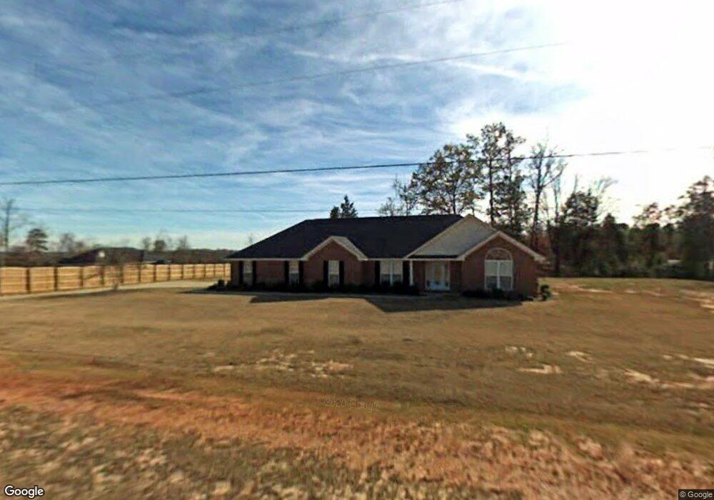
529 Boyd Branch Dr Upatoi, GA 31829
Estimated Value: $348,104 - $439,000
3
Beds
3
Baths
2,255
Sq Ft
$178/Sq Ft
Est. Value
About This Home
This home is located at 529 Boyd Branch Dr, Upatoi, GA 31829 and is currently estimated at $400,276, approximately $177 per square foot. 529 Boyd Branch Dr is a home located in Harris County with nearby schools including Mathews Elementary School, Aaron Cohn Middle School, and Shaw High School.
Ownership History
Date
Name
Owned For
Owner Type
Purchase Details
Closed on
Jul 31, 2002
Sold by
Brittland Properties Inc
Bought by
Williams Cynthia
Current Estimated Value
Purchase Details
Closed on
Oct 11, 2001
Bought by
Brittland Properties
Create a Home Valuation Report for This Property
The Home Valuation Report is an in-depth analysis detailing your home's value as well as a comparison with similar homes in the area
Home Values in the Area
Average Home Value in this Area
Purchase History
| Date | Buyer | Sale Price | Title Company |
|---|---|---|---|
| Williams Cynthia | $209,900 | -- | |
| Brittland Properties | $35,000 | -- |
Source: Public Records
Tax History Compared to Growth
Tax History
| Year | Tax Paid | Tax Assessment Tax Assessment Total Assessment is a certain percentage of the fair market value that is determined by local assessors to be the total taxable value of land and additions on the property. | Land | Improvement |
|---|---|---|---|---|
| 2024 | $3,196 | $118,270 | $16,000 | $102,270 |
| 2023 | $2,204 | $98,354 | $14,000 | $84,354 |
| 2022 | $2,666 | $98,354 | $14,000 | $84,354 |
| 2021 | $2,475 | $88,006 | $14,000 | $74,006 |
| 2020 | $2,475 | $88,006 | $14,000 | $74,006 |
| 2019 | $2,325 | $85,680 | $14,000 | $71,680 |
| 2018 | $2,372 | $85,680 | $14,000 | $71,680 |
| 2017 | $2,373 | $85,680 | $14,000 | $71,680 |
| 2016 | $2,089 | $82,434 | $14,000 | $68,434 |
| 2015 | $2,093 | $82,434 | $14,000 | $68,434 |
| 2014 | $2,179 | $85,750 | $14,000 | $71,750 |
| 2013 | -- | $92,433 | $24,000 | $68,433 |
Source: Public Records
Map
Nearby Homes
- 0 Boyd Ct
- 8585 Mckee Rd
- 57 Old Chimney Ct
- 64 Steele Creek Dr
- 7019 Kendall Creek Dr
- 8701 Mckee Rd
- 8711 Mckee Rd
- 8715 Mckee Rd
- 8695 Mckee Rd
- 8705 Mckee Rd
- Cypress Plan at Bowers Creek
- Cannaberra Plan at Bowers Creek
- Belmont Plan at Bowers Creek
- Jackson Plan at Bowers Creek
- Alder Plan at Bowers Creek
- Oakwood Plan at Bowers Creek
- Magnolia Plan at Bowers Creek
- Ash II Plan at Bowers Creek
- Harrison Plan at Bowers Creek
- 7901 Shallowford Rd
- 72 Boyd Branch Dr
- 32 Branch Ct
- 10014 Mckee Rd
- 10026 Mckee Rd
- 60 Branch Ct
- 109 Boyd Branch Dr
- 33 Boyd Ct
- 0 Mckee Rd Unit 3 8204335
- 0 Mckee Rd Unit 4 8204331
- 0 Mckee Rd Unit 2 8275177
- 0 Mckee Rd Unit 8204335
- 0 Mckee Rd Unit 214694
- 0 Mckee Rd Unit 181835
- 0 Mckee Rd Unit 8784809
- 0 Mckee Rd Unit 7528223
- 0 Mckee Rd Unit 7629219
- 0 Mckee Rd Unit 8366336
- 0 Mckee Rd Unit 8547133
- 8826 Mckee Rd
- 3715 Mckee Rd