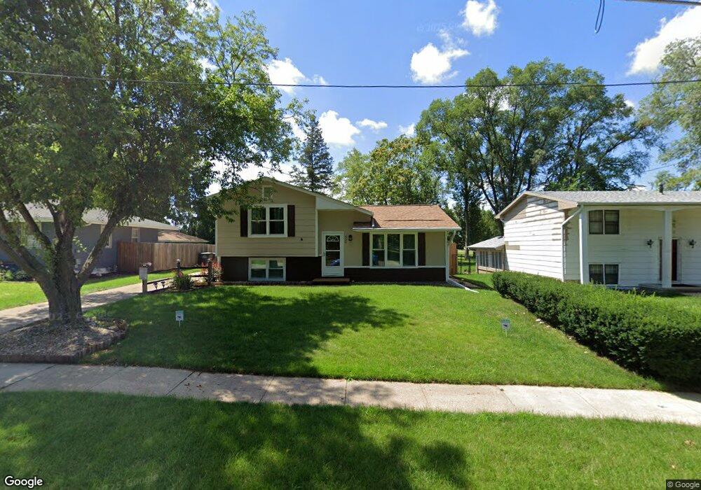
529 Hart Ave Des Moines, IA 50315
South Central DSM NeighborhoodEstimated Value: $215,000 - $244,000
4
Beds
2
Baths
880
Sq Ft
$260/Sq Ft
Est. Value
About This Home
This home is located at 529 Hart Ave, Des Moines, IA 50315 and is currently estimated at $228,915, approximately $260 per square foot. 529 Hart Ave is a home located in Polk County with nearby schools including Lovejoy Elementary School, Mccombs Middle School, and Lincoln High School.
Ownership History
Date
Name
Owned For
Owner Type
Purchase Details
Closed on
Sep 29, 1998
Sold by
Diehl David D and Diehl Nancy J
Bought by
Ubaldo Sam R and Ubaldo Karen D
Current Estimated Value
Home Financials for this Owner
Home Financials are based on the most recent Mortgage that was taken out on this home.
Original Mortgage
$92,300
Interest Rate
6.98%
Mortgage Type
VA
Create a Home Valuation Report for This Property
The Home Valuation Report is an in-depth analysis detailing your home's value as well as a comparison with similar homes in the area
Home Values in the Area
Average Home Value in this Area
Purchase History
| Date | Buyer | Sale Price | Title Company |
|---|---|---|---|
| Ubaldo Sam R | $90,000 | -- |
Source: Public Records
Mortgage History
| Date | Status | Borrower | Loan Amount |
|---|---|---|---|
| Previous Owner | Ubaldo Sam R | $92,300 |
Source: Public Records
Tax History Compared to Growth
Tax History
| Year | Tax Paid | Tax Assessment Tax Assessment Total Assessment is a certain percentage of the fair market value that is determined by local assessors to be the total taxable value of land and additions on the property. | Land | Improvement |
|---|---|---|---|---|
| 2025 | $3,310 | $206,600 | $34,600 | $172,000 |
| 2024 | $3,310 | $189,900 | $31,400 | $158,500 |
| 2023 | $3,310 | $189,900 | $31,400 | $158,500 |
| 2022 | $3,282 | $152,700 | $26,100 | $126,600 |
| 2021 | $3,280 | $152,700 | $26,100 | $126,600 |
| 2020 | $3,348 | $143,300 | $24,400 | $118,900 |
| 2019 | $3,016 | $141,300 | $24,400 | $116,900 |
| 2018 | $2,978 | $124,000 | $21,000 | $103,000 |
| 2017 | $2,836 | $124,000 | $21,000 | $103,000 |
| 2016 | $2,756 | $116,600 | $19,400 | $97,200 |
| 2015 | $2,756 | $116,600 | $19,400 | $97,200 |
| 2014 | $2,888 | $120,700 | $19,700 | $101,000 |
Source: Public Records
Map
Nearby Homes
- 613 Cummins Rd
- 433 E Payton Ave
- 401 E Wall Ave
- 817 E Diehl Ave
- 439 E Porter Ave
- 313 E Payton Ave
- 5600 SE 4th St
- 217 E Payton Ave
- 5205 SE 9th St
- 7500 SE Bloomfield Rd Unit 40
- 801 E Hackley Ave
- 712 E Hackley Ave
- 904 E Hackley Ave
- 5501 S Union St
- 5936 SW 2nd St
- 5814 SW 3rd St
- 401 E Mckinley Ave
- 1660 E Army Post Rd
- 303 Porter Ave
- 6204 SW 5th St