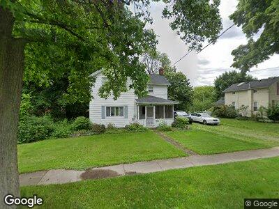
529 High St Doylestown, OH 44230
Estimated Value: $204,000 - $273,000
3
Beds
2
Baths
1,708
Sq Ft
$137/Sq Ft
Est. Value
About This Home
This home is located at 529 High St, Doylestown, OH 44230 and is currently estimated at $233,632, approximately $136 per square foot. 529 High St is a home located in Wayne County with nearby schools including Hazel Harvey Elementary School, Chippewa Intermediate School, and Chippewa Jr./Sr. High School.
Ownership History
Date
Name
Owned For
Owner Type
Purchase Details
Closed on
Apr 17, 2016
Sold by
Uhl Ed and Uhl Judy
Bought by
Uhl Ed and Uhl Judy
Current Estimated Value
Purchase Details
Closed on
Jul 16, 2010
Sold by
The Bank Of New York Mellon
Bought by
Uhl Ed and Uhl Judy
Purchase Details
Closed on
Mar 22, 2010
Sold by
Sheriff Of Wayne County, Ohio Thomas G Maurer
Bought by
Bank Of New York Mellon
Purchase Details
Closed on
Mar 16, 2010
Sold by
Sheriff Of Wayne County, Ohio Thomas G Maurer
Bought by
Bank Of New York Mellon
Purchase Details
Closed on
Nov 1, 2006
Sold by
Benner James W and Benner Sally A
Bought by
Miller Michael L
Home Financials for this Owner
Home Financials are based on the most recent Mortgage that was taken out on this home.
Original Mortgage
$107,920
Interest Rate
8.12%
Mortgage Type
Adjustable Rate Mortgage/ARM
Create a Home Valuation Report for This Property
The Home Valuation Report is an in-depth analysis detailing your home's value as well as a comparison with similar homes in the area
Home Values in the Area
Average Home Value in this Area
Purchase History
| Date | Buyer | Sale Price | Title Company |
|---|---|---|---|
| Uhl Ed | -- | Attorney | |
| Uhl Ed | $75,000 | Fidelty National Title | |
| Bank Of New York Mellon | $63,334 | -- | |
| Bank Of New York Mellon | $63,334 | -- | |
| Miller Michael L | $134,900 | Midland Title-First American |
Source: Public Records
Mortgage History
| Date | Status | Borrower | Loan Amount |
|---|---|---|---|
| Previous Owner | Miller Michael L | $107,920 |
Source: Public Records
Tax History Compared to Growth
Tax History
| Year | Tax Paid | Tax Assessment Tax Assessment Total Assessment is a certain percentage of the fair market value that is determined by local assessors to be the total taxable value of land and additions on the property. | Land | Improvement |
|---|---|---|---|---|
| 2024 | $1,510 | $40,080 | $14,770 | $25,310 |
| 2023 | $1,510 | $40,230 | $14,770 | $25,460 |
| 2022 | $1,285 | $31,220 | $11,330 | $19,890 |
| 2021 | $1,312 | $31,600 | $11,330 | $20,270 |
| 2020 | $1,322 | $31,600 | $11,330 | $20,270 |
| 2019 | $1,298 | $29,920 | $15,710 | $14,210 |
| 2018 | $1,310 | $29,920 | $15,710 | $14,210 |
| 2017 | $1,300 | $29,920 | $15,710 | $14,210 |
| 2016 | $1,270 | $28,770 | $15,110 | $13,660 |
| 2015 | $1,266 | $28,770 | $15,110 | $13,660 |
| 2014 | $1,124 | $28,770 | $15,110 | $13,660 |
| 2013 | $1,079 | $26,780 | $14,130 | $12,650 |
Source: Public Records
Map
Nearby Homes
- 680 Thorn Way
- 620 Thorn Way
- 265 Thorn Way
- 400 Thorn Way
- 365 Thorn Way
- VL 1067 Homan Dr
- 156 Gates St
- V/L 1050 Melanie Ln
- 605 Gates St
- 582 Church St
- 587 Silver Creek Dr
- 121 S Portage St
- 13707 Calaboone Rd
- 13872 Allison Dr
- 200 Vineyard Way
- 15375 Calaboone Rd
- 15500 Freedom Dr
- 236 Willow Way
- 15535 Portage St
- 14740 Oak Grove Dr Unit 18