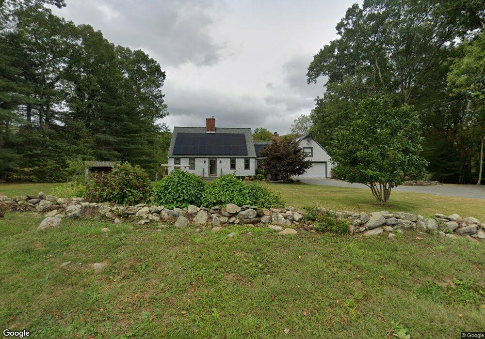
53 Bamforth Rd Haddam, CT 06438
Estimated Value: $637,968 - $823,000
3
Beds
3
Baths
2,218
Sq Ft
$319/Sq Ft
Est. Value
About This Home
This home is located at 53 Bamforth Rd, Haddam, CT 06438 and is currently estimated at $707,492, approximately $318 per square foot. 53 Bamforth Rd is a home located in Middlesex County with nearby schools including Haddam-Killingworth High School.
Ownership History
Date
Name
Owned For
Owner Type
Purchase Details
Closed on
Mar 30, 2012
Sold by
Charles R Paradis Ret
Bought by
Paradis Charles R and Paradis Janice A
Current Estimated Value
Purchase Details
Closed on
Sep 16, 2004
Sold by
Helenek Louise A and Helenek Charles S
Bought by
Munroe Janice A and Paradis Charles R
Home Financials for this Owner
Home Financials are based on the most recent Mortgage that was taken out on this home.
Original Mortgage
$333,700
Interest Rate
6.02%
Create a Home Valuation Report for This Property
The Home Valuation Report is an in-depth analysis detailing your home's value as well as a comparison with similar homes in the area
Home Values in the Area
Average Home Value in this Area
Purchase History
| Date | Buyer | Sale Price | Title Company |
|---|---|---|---|
| Paradis Charles R | -- | -- | |
| Munroe Janice A | $490,000 | -- |
Source: Public Records
Mortgage History
| Date | Status | Borrower | Loan Amount |
|---|---|---|---|
| Previous Owner | Munroe Janice A | $100,000 | |
| Previous Owner | Munroe Janice A | $333,700 | |
| Previous Owner | Munroe Janice A | $50,000 |
Source: Public Records
Tax History
| Year | Tax Paid | Tax Assessment Tax Assessment Total Assessment is a certain percentage of the fair market value that is determined by local assessors to be the total taxable value of land and additions on the property. | Land | Improvement |
|---|---|---|---|---|
| 2025 | $9,564 | $278,440 | $95,440 | $183,000 |
| 2024 | $9,564 | $278,440 | $95,440 | $183,000 |
| 2023 | $9,431 | $278,440 | $95,440 | $183,000 |
| 2022 | $9,002 | $278,440 | $95,440 | $183,000 |
| 2021 | $8,955 | $278,440 | $95,440 | $183,000 |
| 2020 | $9,127 | $288,000 | $115,910 | $172,090 |
| 2019 | $9,127 | $288,000 | $115,910 | $172,090 |
| 2018 | $9,127 | $288,000 | $115,910 | $172,090 |
| 2017 | $9,127 | $288,000 | $115,910 | $172,090 |
| 2016 | $8,986 | $288,000 | $115,910 | $172,090 |
| 2015 | $9,275 | $297,280 | $115,910 | $181,370 |
| 2014 | $9,183 | $297,280 | $115,910 | $181,370 |
Source: Public Records
Map
Nearby Homes
- 0 Saybrook Rd
- 195A Injun Hollow Rd
- 114 Walkley Hill Rd
- 428 Plains Rd
- 0 S Dish Mill Rd Unit 24082788
- 10 November Trail
- 1572 Saybrook Rd
- 2 Morgan Ln
- 77 Main St
- 882 Killingworth Rd
- 63 Burr Rd
- 214 Thayer Rd
- 23 Main St
- 86 Christian Hill Rd
- 2 Norwich Rd
- 26 Boulder Dell Rd
- 59 Hidden Lake Rd
- 424 Moodus Rd
- 418 Moodus Rd
- 420 Moodus Rd
- 61 Bamforth Rd
- 75 Bamforth Rd
- 176 Hayden Hill Rd
- 172 Hayden Hill Rd
- 164 Hayden Hill Rd
- 87 Bamforth Rd
- 158 Hayden Hill Rd
- 154 Hayden Hill Rd
- 21 Bamforth Rd
- 180 Hayden Hill Rd
- 93 Bamforth Rd
- 146 Hayden Hill Rd
- 14 Bamforth Rd
- 3 Brookes Ct
- 3 Brookes Ct Unit A213
- 3 Brookes Ct Unit C212
- 3 Brookes Ct Unit A222
- 3 Brookes Ct Unit A322
- 3 Brookes Ct Unit A221
- 184 Hayden Hill Rd
Your Personal Tour Guide
Ask me questions while you tour the home.