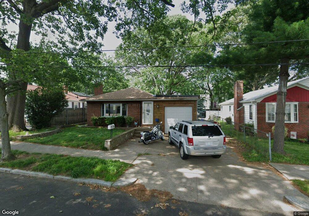
53 Sinclair Ave Cranston, RI 02907
Estimated Value: $316,000 - $415,000
3
Beds
2
Baths
1,524
Sq Ft
$248/Sq Ft
Est. Value
About This Home
This home is located at 53 Sinclair Ave, Cranston, RI 02907 and is currently estimated at $377,846, approximately $247 per square foot. 53 Sinclair Ave is a home located in Providence County with nearby schools including Paul Cuffee High School and Sophia Academy.
Ownership History
Date
Name
Owned For
Owner Type
Purchase Details
Closed on
Oct 8, 2019
Sold by
Gooden Jacqueline A
Bought by
Smith Guy
Current Estimated Value
Home Financials for this Owner
Home Financials are based on the most recent Mortgage that was taken out on this home.
Original Mortgage
$40,000
Outstanding Balance
$34,731
Interest Rate
3.5%
Mortgage Type
Purchase Money Mortgage
Estimated Equity
$343,115
Create a Home Valuation Report for This Property
The Home Valuation Report is an in-depth analysis detailing your home's value as well as a comparison with similar homes in the area
Purchase History
| Date | Buyer | Sale Price | Title Company |
|---|---|---|---|
| Smith Guy | $30,000 | -- |
Source: Public Records
Mortgage History
| Date | Status | Borrower | Loan Amount |
|---|---|---|---|
| Open | Smith Guy | $40,000 |
Source: Public Records
Tax History
| Year | Tax Paid | Tax Assessment Tax Assessment Total Assessment is a certain percentage of the fair market value that is determined by local assessors to be the total taxable value of land and additions on the property. | Land | Improvement |
|---|---|---|---|---|
| 2025 | $2,844 | $338,600 | $129,600 | $209,000 |
| 2024 | $4,951 | $269,800 | $87,100 | $182,700 |
| 2023 | $4,951 | $269,800 | $87,100 | $182,700 |
| 2022 | $4,802 | $269,800 | $87,100 | $182,700 |
| 2021 | $4,910 | $199,900 | $57,900 | $142,000 |
| 2020 | $4,910 | $199,900 | $57,900 | $142,000 |
| 2019 | $4,910 | $199,900 | $57,900 | $142,000 |
| 2018 | $5,018 | $157,000 | $52,700 | $104,300 |
| 2017 | $5,018 | $157,000 | $52,700 | $104,300 |
| 2016 | $5,018 | $157,000 | $52,700 | $104,300 |
| 2015 | $4,614 | $139,400 | $41,000 | $98,400 |
| 2014 | $4,705 | $139,400 | $41,000 | $98,400 |
| 2013 | $4,705 | $139,400 | $41,000 | $98,400 |
Source: Public Records
Map
Nearby Homes
- 31 Burrows St
- 129 Alger Ave
- 125 Alger Ave
- 113 Alger Ave
- 43 Woodbine St
- 102 Dixon St Unit 12
- 227 Sackett St
- 99 Dixon St
- 236 Gallatin St
- 309 Station St
- 55 Togansett Rd
- 326 Beckwith St
- 90 Garden St
- 41 Cottage St
- 00 Westmore St
- 26 Westmore St
- 187 Warrington St
- 288 Pontiac Ave
- 140 Eldridge St
- 152 Woodbine St
- 51 Sinclair Ave
- 61 Sinclair Ave
- 50 Rutherglen Ave
- 58 Rutherglen Ave
- 46 Rutherglen Ave
- 56 Sinclair Ave
- 62 Rutherglen Ave
- 42 Rutherglen Ave
- 71 Sinclair Ave
- 41 Sinclair Ave
- 62 Sinclair Ave
- 52 Sinclair Ave
- 48 Sinclair Ave
- 66 Rutherglen Ave
- 70 Sinclair Ave
- 0 Falcon Ct Unit 1031383
- 0 Falcon Ct Unit 1031384
- 44 Sinclair Ave
- 78 Alexander St
- 70 Rutherglen Ave
Your Personal Tour Guide
Ask me questions while you tour the home.