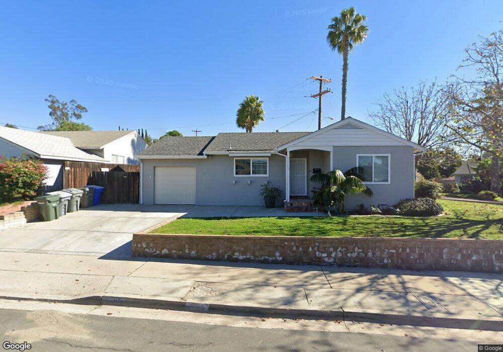
5305 Kiowa Dr La Mesa, CA 91942
Estimated Value: $794,000 - $925,000
3
Beds
2
Baths
1,402
Sq Ft
$608/Sq Ft
Est. Value
About This Home
This home is located at 5305 Kiowa Dr, La Mesa, CA 91942 and is currently estimated at $851,917, approximately $607 per square foot. 5305 Kiowa Dr is a home located in San Diego County with nearby schools including Maryland Avenue Elementary School, Parkway Academy, and Grossmont High School.
Ownership History
Date
Name
Owned For
Owner Type
Purchase Details
Closed on
Sep 15, 2011
Sold by
Daggett Mark Alan and Daggett Deborah Lynn
Bought by
Daggett Mark Alan and Daggett Deborah Lynn
Current Estimated Value
Purchase Details
Closed on
Dec 17, 2009
Sold by
Daggett Deborah Peace and Daggett Deborah Lynn
Bought by
Daggett Mark Alan and Daggett Deborah Lynn
Purchase Details
Closed on
Jun 23, 2000
Sold by
Peace Peace W and Peace Dorothy C
Bought by
Peace Family Partnership Lp
Create a Home Valuation Report for This Property
The Home Valuation Report is an in-depth analysis detailing your home's value as well as a comparison with similar homes in the area
Home Values in the Area
Average Home Value in this Area
Purchase History
| Date | Buyer | Sale Price | Title Company |
|---|---|---|---|
| Daggett Mark Alan | -- | None Available | |
| Daggett Mark Alan | -- | None Available | |
| Daggett Deborah Peace | -- | None Available | |
| Peace Family Partnership Lp | -- | -- | |
| Peace W A | -- | -- |
Source: Public Records
Tax History Compared to Growth
Tax History
| Year | Tax Paid | Tax Assessment Tax Assessment Total Assessment is a certain percentage of the fair market value that is determined by local assessors to be the total taxable value of land and additions on the property. | Land | Improvement |
|---|---|---|---|---|
| 2025 | $5,760 | $432,409 | $225,885 | $206,524 |
| 2024 | $5,760 | $423,931 | $221,456 | $202,475 |
| 2023 | $5,519 | $415,619 | $217,114 | $198,505 |
| 2022 | $5,421 | $407,470 | $212,857 | $194,613 |
| 2021 | $5,293 | $399,482 | $208,684 | $190,798 |
| 2020 | $5,134 | $395,387 | $206,545 | $188,842 |
| 2019 | $5,072 | $387,636 | $202,496 | $185,140 |
| 2018 | $5,073 | $380,036 | $198,526 | $181,510 |
| 2017 | $5,082 | $372,585 | $194,634 | $177,951 |
| 2016 | $4,978 | $365,280 | $190,818 | $174,462 |
| 2015 | $4,977 | $359,794 | $187,952 | $171,842 |
| 2014 | $4,905 | $352,747 | $184,271 | $168,476 |
Source: Public Records
Map
Nearby Homes
- 7195 Macquarie St
- 7495 Oakland Rd Unit 23
- 7495 Oakland Rd Unit 33
- 5450 Kiowa Dr Unit 81
- 5366 Lake Murray Blvd
- 7500 Parkway Dr Unit 306
- 7506 Parkway Dr Unit 202
- 7506 Parkway Dr Unit 104
- 7180-82 Mohawk St
- 7127 Saranac St
- 7000 Saranac St Unit 54
- 7000 Saranac St Unit 2
- 5590 Shasta Ln
- 5015 Comanche Dr
- 6955 Alvarado Rd Unit 29
- 6955 Alvarado Rd Unit 30
- 6955 Alvarado Rd Unit 59
- 7475 El Cajon Blvd
- 6911 Alvarado Rd Unit 20
- 7700 Parkway Dr Unit 17
- 5284 Maryland Ave
- 5315 Kiowa Dr
- 5282 Maryland Ave
- 7255 Magruder St
- 5269 Maryland Ave
- 5325 Kiowa Dr
- 7250 Grable St
- 5265 Maryland Ave
- 5285 Maryland Ave
- 7245 Magruder St
- 7250 Magruder St
- 5345 Kiowa Dr
- 5260 Guessman Ave
- 7240 Grable St
- 5286 Maryland Ave
- 5290 Maryland Ave
- 5295 Maryland Ave
- 7240 Magruder St
- 7235 Magruder St
- 5255 Maryland Ave