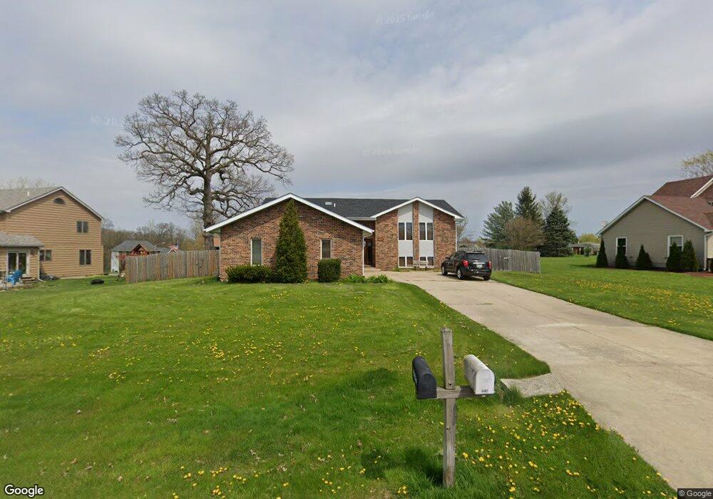
5310 Hanley Ln Crown Point, IN 46307
Estimated Value: $359,000 - $401,000
3
Beds
2
Baths
2,980
Sq Ft
$128/Sq Ft
Est. Value
About This Home
This home is located at 5310 Hanley Ln, Crown Point, IN 46307 and is currently estimated at $381,429, approximately $127 per square foot. 5310 Hanley Ln is a home located in Lake County with nearby schools including Hal E Clark Middle School, Peifer Elementary School, and Lake Central High School.
Ownership History
Date
Name
Owned For
Owner Type
Purchase Details
Closed on
Dec 2, 2013
Sold by
Conry Leo R and Conry Adriana C
Bought by
Conry Adriana C
Current Estimated Value
Home Financials for this Owner
Home Financials are based on the most recent Mortgage that was taken out on this home.
Original Mortgage
$177,000
Interest Rate
4.1%
Mortgage Type
New Conventional
Create a Home Valuation Report for This Property
The Home Valuation Report is an in-depth analysis detailing your home's value as well as a comparison with similar homes in the area
Home Values in the Area
Average Home Value in this Area
Purchase History
| Date | Buyer | Sale Price | Title Company |
|---|---|---|---|
| Conry Adriana C | -- | None Available |
Source: Public Records
Mortgage History
| Date | Status | Borrower | Loan Amount |
|---|---|---|---|
| Closed | Conry Adriana C | $177,000 |
Source: Public Records
Tax History Compared to Growth
Tax History
| Year | Tax Paid | Tax Assessment Tax Assessment Total Assessment is a certain percentage of the fair market value that is determined by local assessors to be the total taxable value of land and additions on the property. | Land | Improvement |
|---|---|---|---|---|
| 2024 | $6,064 | $317,000 | $67,000 | $250,000 |
| 2023 | $2,695 | $297,800 | $67,000 | $230,800 |
| 2022 | $2,695 | $274,400 | $67,000 | $207,400 |
| 2021 | $2,492 | $260,400 | $67,000 | $193,400 |
| 2020 | $2,466 | $252,800 | $67,000 | $185,800 |
| 2019 | $2,364 | $226,300 | $49,100 | $177,200 |
| 2018 | $2,339 | $222,100 | $48,200 | $173,900 |
| 2017 | $2,243 | $224,500 | $48,200 | $176,300 |
| 2016 | $2,059 | $209,800 | $48,200 | $161,600 |
| 2014 | $2,144 | $225,500 | $49,200 | $176,300 |
| 2013 | $2,133 | $219,800 | $49,100 | $170,700 |
Source: Public Records
Map
Nearby Homes
- 8748 Durbin Ln
- 5063 W 89th Ct
- 9017 Mathews St
- 5652 Burr Ridge Cir
- Wysteria Plan at Burr Ridge
- 4974 W 87th Place
- 8777 Burr Ridge Cir
- 9041 Clark Place
- 8849 Calhoun Place
- 4862 W 92nd Ave
- 4930 W 84th Terrace
- 6076 Wexford Way
- 9204 Wright St
- 6440 W 89th Ave
- 5547 Maggie Mae Ct
- 6308 W 91st Ave
- 5480 Victoria Place
- 2921 Morningside Dr
- 8109 Victoria Place
- 10444 Whitney Place