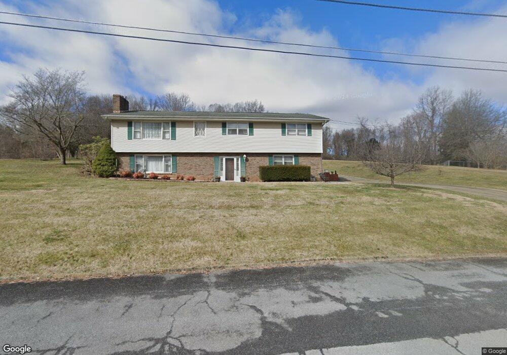
5312 Lonesome Pine Rd Kingsport, TN 37664
Estimated Value: $290,313 - $396,000
--
Bed
2
Baths
2,377
Sq Ft
$140/Sq Ft
Est. Value
About This Home
This home is located at 5312 Lonesome Pine Rd, Kingsport, TN 37664 and is currently estimated at $332,328, approximately $139 per square foot. 5312 Lonesome Pine Rd is a home located in Sullivan County with nearby schools including Indian Springs Elementary School and Sullivan Central Middle School.
Ownership History
Date
Name
Owned For
Owner Type
Purchase Details
Closed on
Jul 31, 2008
Sold by
Gross Alan A
Bought by
Barnes William L
Current Estimated Value
Purchase Details
Closed on
Apr 18, 2007
Sold by
Kay Cornett Lorraine
Bought by
Gross Alan A
Home Financials for this Owner
Home Financials are based on the most recent Mortgage that was taken out on this home.
Original Mortgage
$112,000
Interest Rate
6.1%
Purchase Details
Closed on
Mar 27, 1992
Create a Home Valuation Report for This Property
The Home Valuation Report is an in-depth analysis detailing your home's value as well as a comparison with similar homes in the area
Home Values in the Area
Average Home Value in this Area
Purchase History
| Date | Buyer | Sale Price | Title Company |
|---|---|---|---|
| Barnes William L | -- | -- | |
| Gross Alan A | $147,000 | -- | |
| -- | $74,000 | -- |
Source: Public Records
Mortgage History
| Date | Status | Borrower | Loan Amount |
|---|---|---|---|
| Previous Owner | -- | $112,000 |
Source: Public Records
Tax History Compared to Growth
Tax History
| Year | Tax Paid | Tax Assessment Tax Assessment Total Assessment is a certain percentage of the fair market value that is determined by local assessors to be the total taxable value of land and additions on the property. | Land | Improvement |
|---|---|---|---|---|
| 2024 | $1,083 | $43,400 | $6,000 | $37,400 |
| 2023 | $1,044 | $43,400 | $6,000 | $37,400 |
| 2022 | $1,044 | $43,400 | $6,000 | $37,400 |
| 2021 | $1,044 | $43,400 | $6,000 | $37,400 |
| 2020 | $1,055 | $43,400 | $6,000 | $37,400 |
| 2019 | $1,055 | $41,050 | $6,000 | $35,050 |
| 2018 | $1,047 | $41,050 | $6,000 | $35,050 |
| 2017 | $1,047 | $41,050 | $6,000 | $35,050 |
| 2016 | $964 | $37,450 | $6,000 | $31,450 |
| 2014 | $863 | $37,438 | $0 | $0 |
Source: Public Records
Map
Nearby Homes
- 5404 Memorial Blvd
- 5509 Memorial Blvd
- 416 S Valley View Cir
- 509 Amelia Ct
- 295 Southridge Dr
- Lot 3 Country Dr
- Lot 2 Country Dr
- Lot 21 Country Dr
- 121 Southridge Dr
- 128 Southridge Dr
- 316 Montezuma Rd
- 708 Hill Rd
- 160 Sugarcane Ln
- 376 Cain Dr
- 172 Sugarcane Ln
- Madison Plan at Fieldcrest Acres
- Salem Plan at Fieldcrest Acres
- Pamlico Plan at Fieldcrest Acres
- Cali Plan at Fieldcrest Acres
- Allex Plan at Fieldcrest Acres
- 5316 Lonesome Pine Rd
- 5330 Lonesome Pine Rd
- 5308 Lonesome Pine Rd
- 5305 Lonesome Pine Rd
- 5317 Lonesome Pine Rd
- Lot # 0 Lonesome Pine Rd
- 0 Lonesome Pine Rd
- 5301 Lonesome Pine Rd
- 5304 Lonesome Pine Rd
- 5400 Lonesome Pine Rd
- 5408 Lonesome Pine Rd
- 5350 Lonesome Pine Rd
- 5412 Lonesome Pine Rd
- 5401 Lonesome Pine Rd
- 5416 Lonesome Pine Rd
- 240 Emory Harr Private Dr
- 218 Emory Harr Private Dr
- 5410 Odd Fellow Rd
- 226 Emory Harr Private Dr
- 100 Cedar Brook Ct