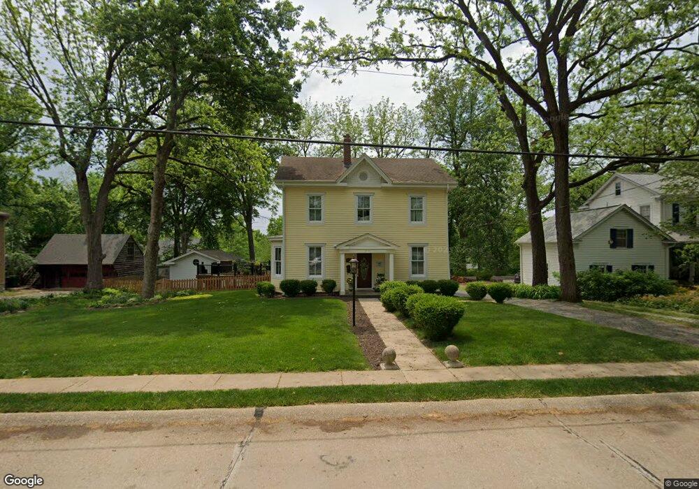
532 Lee Ave Saint Louis, MO 63119
Estimated Value: $755,000 - $833,000
4
Beds
3
Baths
2,613
Sq Ft
$302/Sq Ft
Est. Value
About This Home
This home is located at 532 Lee Ave, Saint Louis, MO 63119 and is currently estimated at $788,428, approximately $301 per square foot. 532 Lee Ave is a home located in St. Louis County with nearby schools including Bristol Elementary School, Hixson Middle School, and Webster Groves High School.
Ownership History
Date
Name
Owned For
Owner Type
Purchase Details
Closed on
Apr 13, 2001
Sold by
Vansant Karey A and Jolly Sue A
Bought by
Vansant Karey and Vansant Sue Jolly
Current Estimated Value
Purchase Details
Closed on
Jul 30, 1997
Sold by
Isenberg Laverne A and Isenberg Susan K
Bought by
Vansant Karey A and Jolly Vansant Sue A
Home Financials for this Owner
Home Financials are based on the most recent Mortgage that was taken out on this home.
Original Mortgage
$195,000
Outstanding Balance
$28,192
Interest Rate
7.6%
Estimated Equity
$760,236
Create a Home Valuation Report for This Property
The Home Valuation Report is an in-depth analysis detailing your home's value as well as a comparison with similar homes in the area
Home Values in the Area
Average Home Value in this Area
Purchase History
| Date | Buyer | Sale Price | Title Company |
|---|---|---|---|
| Vansant Karey | -- | -- | |
| Vansant Karey A | -- | -- |
Source: Public Records
Mortgage History
| Date | Status | Borrower | Loan Amount |
|---|---|---|---|
| Open | Vansant Karey A | $195,000 |
Source: Public Records
Tax History Compared to Growth
Tax History
| Year | Tax Paid | Tax Assessment Tax Assessment Total Assessment is a certain percentage of the fair market value that is determined by local assessors to be the total taxable value of land and additions on the property. | Land | Improvement |
|---|---|---|---|---|
| 2025 | $7,462 | $134,660 | $59,570 | $75,090 |
| 2024 | $7,462 | $107,520 | $49,610 | $57,910 |
| 2023 | $7,425 | $107,520 | $49,610 | $57,910 |
| 2022 | $6,722 | $90,350 | $35,740 | $54,610 |
| 2021 | $6,699 | $90,350 | $35,740 | $54,610 |
| 2020 | $6,450 | $81,010 | $34,690 | $46,320 |
| 2019 | $6,403 | $81,010 | $34,690 | $46,320 |
| 2018 | $6,614 | $74,340 | $27,090 | $47,250 |
| 2017 | $6,570 | $74,340 | $27,090 | $47,250 |
| 2016 | $6,394 | $69,220 | $19,440 | $49,780 |
| 2015 | $6,427 | $69,220 | $19,440 | $49,780 |
| 2014 | $7,040 | $73,800 | $15,180 | $58,620 |
Source: Public Records
Map
Nearby Homes
- 541 W Kirkham Ave
- 28 Berry Road Park
- 426 W Kirkham Ave
- 529 Cyril Dr
- 404 W Kirkham Ave
- 827 Yosemite Dr
- 336 Madison Ave
- 218 Euclid Ave
- 330 Lithia Ave
- 9721 Greenwood Terrace
- 144 S Rock Hill Rd
- 200 Blackmer Place
- 1025 Glenmoor Ln
- 2918 Wingate Ct
- 1048 Martha Ln
- 617 N Elm Ave
- 156 Gray Ave
- 1146 Kortwright Ave
- 987 Dwyer Ave
- 946 Dwyer Ave