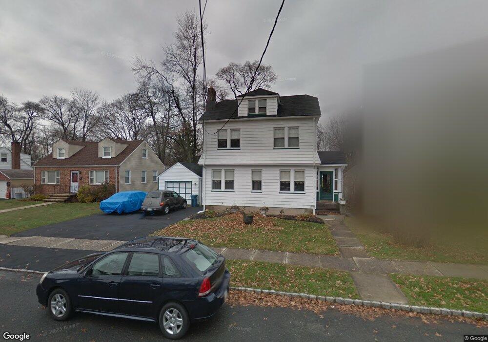
532 Pierson St Westfield, NJ 07090
Estimated Value: $717,000 - $949,722
--
Bed
--
Bath
1,987
Sq Ft
$425/Sq Ft
Est. Value
About This Home
This home is located at 532 Pierson St, Westfield, NJ 07090 and is currently estimated at $844,181, approximately $424 per square foot. 532 Pierson St is a home located in Union County with nearby schools including McKinley Elementary School, Edison Intermediate School, and Westfield Senior High School.
Ownership History
Date
Name
Owned For
Owner Type
Purchase Details
Closed on
Jun 23, 2020
Sold by
Carey Stewart
Bought by
Lopresti Rae R
Current Estimated Value
Home Financials for this Owner
Home Financials are based on the most recent Mortgage that was taken out on this home.
Original Mortgage
$233,700
Outstanding Balance
$206,767
Interest Rate
3.1%
Mortgage Type
New Conventional
Estimated Equity
$637,414
Purchase Details
Closed on
Nov 2, 2009
Sold by
Davis Ernest J and Lopresti Jean
Bought by
Carey Stewart
Home Financials for this Owner
Home Financials are based on the most recent Mortgage that was taken out on this home.
Original Mortgage
$296,530
Interest Rate
4.86%
Mortgage Type
FHA
Purchase Details
Closed on
Feb 26, 1999
Sold by
Davis Ernest J
Bought by
Davis Ernest J and Lopreste Jean
Home Financials for this Owner
Home Financials are based on the most recent Mortgage that was taken out on this home.
Original Mortgage
$85,000
Interest Rate
6.74%
Mortgage Type
Stand Alone First
Create a Home Valuation Report for This Property
The Home Valuation Report is an in-depth analysis detailing your home's value as well as a comparison with similar homes in the area
Home Values in the Area
Average Home Value in this Area
Purchase History
| Date | Buyer | Sale Price | Title Company |
|---|---|---|---|
| Lopresti Rae R | $246,000 | Associated Title | |
| Carey Stewart | $302,000 | Multiple | |
| Davis Ernest J | -- | Fidelity National Title Ins |
Source: Public Records
Mortgage History
| Date | Status | Borrower | Loan Amount |
|---|---|---|---|
| Open | Lopresti Rae R | $233,700 | |
| Previous Owner | Carey Stewart | $296,530 | |
| Previous Owner | Davis Ernest J | $85,000 |
Source: Public Records
Tax History Compared to Growth
Tax History
| Year | Tax Paid | Tax Assessment Tax Assessment Total Assessment is a certain percentage of the fair market value that is determined by local assessors to be the total taxable value of land and additions on the property. | Land | Improvement |
|---|---|---|---|---|
| 2025 | $14,861 | $659,900 | $251,000 | $408,900 |
| 2024 | $14,557 | $659,900 | $251,000 | $408,900 |
| 2023 | $14,557 | $659,900 | $251,000 | $408,900 |
| 2022 | $9,228 | $427,200 | $251,000 | $176,200 |
| 2021 | $9,240 | $427,200 | $251,000 | $176,200 |
| 2020 | $9,219 | $427,200 | $251,000 | $176,200 |
| 2019 | $9,185 | $427,200 | $251,000 | $176,200 |
| 2018 | $7,382 | $79,400 | $40,200 | $39,200 |
| 2017 | $7,341 | $79,400 | $40,200 | $39,200 |
| 2016 | $7,169 | $79,400 | $40,200 | $39,200 |
| 2015 | $7,026 | $79,400 | $40,200 | $39,200 |
| 2014 | $6,794 | $79,400 | $40,200 | $39,200 |
Source: Public Records
Map
Nearby Homes
- 524 Edgar Rd
- 525 Edgar Rd
- 724 South Ave W Unit 724A
- 554 Hort St
- 614 Dorian Rd
- 538 Westfield Ave
- 350 W Dudley Ave
- 119 Lamberts Mill Rd
- 522 Boulevard
- 303 Prospect St
- 2154 W Broad St
- 260 Prospect St Unit C15
- 517 Clark St
- 1466 Lamberts Mill Rd
- 215 Ross Place Unit J
- 203 Ross Place
- 603 Carleton Rd
- 2314 Longfellow Ave
- 143 Stanmore Place
- 779 Lamberts Mill Rd
- 536 Pierson St
- 528 Pierson St
- 528 Pierson St Unit 1
- 528 Pierson St Unit 2
- 524 Pierson St
- 524 Pierson St Unit 2
- 540 Pierson St
- 531 Pierson St
- 548 Pierson St
- 537 Pierson St
- 524 W Broad St
- 526 W Broad St
- 528 W Broad St
- 522 W Broad St
- 530 W Broad St
- 543 Pierson St
- 518 W Broad St
- 534 W Broad St
- 552 Pierson St
- 516 W Broad St