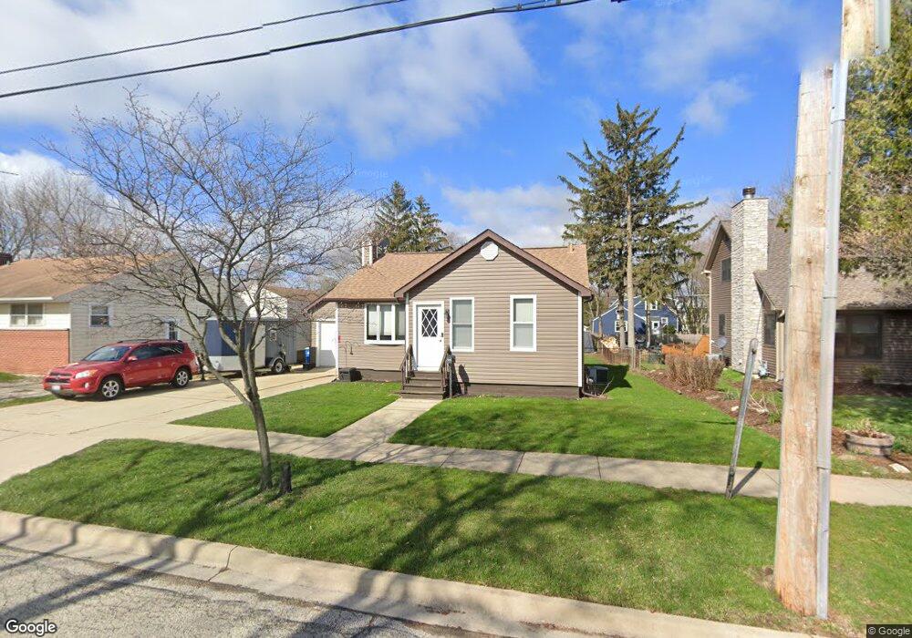
532 S 1st St West Dundee, IL 60118
Estimated Value: $224,254 - $299,000
2
Beds
--
Bath
800
Sq Ft
$326/Sq Ft
Est. Value
About This Home
This home is located at 532 S 1st St, West Dundee, IL 60118 and is currently estimated at $260,564, approximately $325 per square foot. 532 S 1st St is a home located in Kane County with nearby schools including Dundee Highlands Elementary School, Dundee Middle School, and Dundee-Crown High School.
Ownership History
Date
Name
Owned For
Owner Type
Purchase Details
Closed on
Jun 28, 1996
Sold by
Earsley Craig and Earsley Susan E
Bought by
Vandermeir Michael James and Vandermeir Kristin Leigh
Current Estimated Value
Home Financials for this Owner
Home Financials are based on the most recent Mortgage that was taken out on this home.
Original Mortgage
$122,751
Interest Rate
8.18%
Mortgage Type
FHA
Create a Home Valuation Report for This Property
The Home Valuation Report is an in-depth analysis detailing your home's value as well as a comparison with similar homes in the area
Home Values in the Area
Average Home Value in this Area
Purchase History
| Date | Buyer | Sale Price | Title Company |
|---|---|---|---|
| Vandermeir Michael James | $125,000 | Chicago Title Insurance Co |
Source: Public Records
Mortgage History
| Date | Status | Borrower | Loan Amount |
|---|---|---|---|
| Previous Owner | Vandermeir Michael James | $122,751 |
Source: Public Records
Tax History Compared to Growth
Tax History
| Year | Tax Paid | Tax Assessment Tax Assessment Total Assessment is a certain percentage of the fair market value that is determined by local assessors to be the total taxable value of land and additions on the property. | Land | Improvement |
|---|---|---|---|---|
| 2024 | $5,778 | $78,889 | $19,631 | $59,258 |
| 2023 | $5,390 | $70,981 | $17,663 | $53,318 |
| 2022 | $4,675 | $59,064 | $17,663 | $41,401 |
| 2021 | $4,497 | $55,768 | $16,677 | $39,091 |
| 2020 | $4,408 | $54,514 | $16,302 | $38,212 |
| 2019 | $4,253 | $51,751 | $15,476 | $36,275 |
| 2018 | $4,594 | $54,170 | $15,170 | $39,000 |
| 2017 | $4,257 | $50,674 | $14,191 | $36,483 |
| 2016 | $4,330 | $49,064 | $13,740 | $35,324 |
| 2015 | -- | $46,467 | $17,765 | $28,702 |
| 2014 | -- | $45,183 | $17,274 | $27,909 |
| 2013 | -- | $45,622 | $17,803 | $27,819 |
Source: Public Records
Map
Nearby Homes
- 516 S 1st St
- Lot 1 View St
- 505 S 3rd St
- 93 Liberty St
- 560 S 5th St
- 112 Liberty St
- 512 Lisa Rd
- 0000 Strom Dr
- 7 King William St
- 436 Barrington Ave
- 709 Timothy Ct Unit 171
- 849 Hemlock Dr
- 1042 Chateau Bluff Ln
- 519 Oak Dr
- 4 Summit St
- 152 King Ave
- 510 N Van Buren St
- 432 Illinois St
- 152 Aberdeen Dr
- 1 S Lincoln Ave