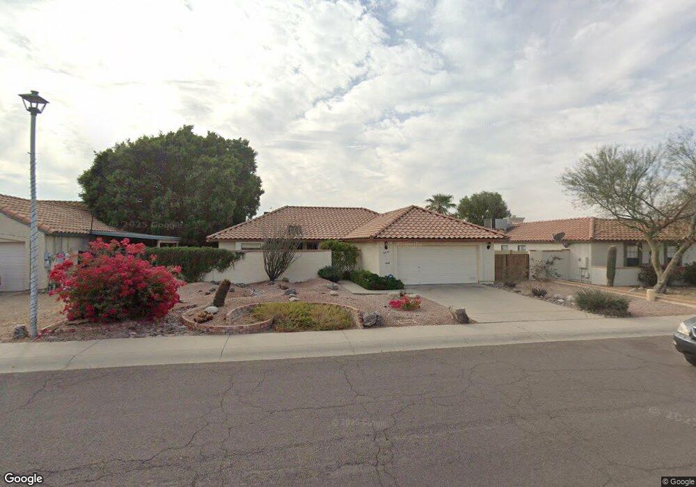
5321 W Brown St Glendale, AZ 85302
Estimated Value: $318,365 - $439,000
--
Bed
3
Baths
1,486
Sq Ft
$271/Sq Ft
Est. Value
About This Home
This home is located at 5321 W Brown St, Glendale, AZ 85302 and is currently estimated at $403,341, approximately $271 per square foot. 5321 W Brown St is a home located in Maricopa County with nearby schools including Heritage School, Ironwood High School, and Heritage Academy - Pointe.
Ownership History
Date
Name
Owned For
Owner Type
Purchase Details
Closed on
Apr 12, 2018
Sold by
Bond Donna Jean
Bought by
Bond Donna J and The Donna J Bond Trust
Current Estimated Value
Purchase Details
Closed on
Jun 18, 2003
Sold by
Bond Donna J and Vanvlaenderen Donna J
Bought by
Bond Donna J
Home Financials for this Owner
Home Financials are based on the most recent Mortgage that was taken out on this home.
Original Mortgage
$83,500
Interest Rate
5.37%
Mortgage Type
Purchase Money Mortgage
Purchase Details
Closed on
Jul 1, 2000
Sold by
Bond Donald G and Bond Lou Emma
Bought by
Bond Donna Jean
Create a Home Valuation Report for This Property
The Home Valuation Report is an in-depth analysis detailing your home's value as well as a comparison with similar homes in the area
Home Values in the Area
Average Home Value in this Area
Purchase History
| Date | Buyer | Sale Price | Title Company |
|---|---|---|---|
| Bond Donna J | -- | None Available | |
| Bond Donna J | -- | Transnation Title Ins Co | |
| Bond Donna Jean | -- | -- |
Source: Public Records
Mortgage History
| Date | Status | Borrower | Loan Amount |
|---|---|---|---|
| Closed | Bond Donna J | $83,500 |
Source: Public Records
Tax History Compared to Growth
Tax History
| Year | Tax Paid | Tax Assessment Tax Assessment Total Assessment is a certain percentage of the fair market value that is determined by local assessors to be the total taxable value of land and additions on the property. | Land | Improvement |
|---|---|---|---|---|
| 2025 | $1,200 | $15,747 | -- | -- |
| 2024 | $1,225 | $14,997 | -- | -- |
| 2023 | $1,225 | $29,430 | $5,880 | $23,550 |
| 2022 | $1,214 | $22,980 | $4,590 | $18,390 |
| 2021 | $1,303 | $20,910 | $4,180 | $16,730 |
| 2020 | $1,322 | $20,030 | $4,000 | $16,030 |
| 2019 | $1,285 | $18,330 | $3,660 | $14,670 |
| 2018 | $1,255 | $16,080 | $3,210 | $12,870 |
| 2017 | $1,264 | $13,710 | $2,740 | $10,970 |
| 2016 | $1,256 | $13,770 | $2,750 | $11,020 |
| 2015 | $1,178 | $10,080 | $2,010 | $8,070 |
Source: Public Records
Map
Nearby Homes
- 5323 W North Ln
- 5407 W North Ln
- 5210 W Ironwood Dr
- 10608 N 53rd Cir
- 5249 W Mountain View Rd
- 10227 N 56th Dr
- 5236 W Peoria Ave Unit 202
- 9710 N 55th Ave
- 9714 N 55th Dr
- 5674 W North Ln
- 5209 W Palo Verde Ave
- 5131 W Christy Dr
- 9623 N 51st Dr
- 10803 N 55th Ave
- Faustus Plan at Marlowe
- Malta Plan at Marlowe
- Tamburlaine Plan at Marlowe
- Christopher Plan at Marlowe
- 4932 W Cheryl Dr
- 4930 W Beryl Ave
- 5315 W Brown St
- 5327 W Brown St
- 5309 W Brown St
- 5333 W Brown St
- 5316 W Brown St
- 10205 N 53rd Ln
- 10203 N 53rd Ln
- 5322 W Brown St
- 5314 W Brown St
- 5303 W Brown St
- 5310 W Brown St
- 5339 W Brown St
- 5308 W Brown St
- 10209 N 53rd Ln
- 10211 N 53rd Ln
- 5345 W Brown St
- 5304 W Brown St
- 10206 N 53rd Ln
- 5313 W Cheryl Dr
- 5319 W Cheryl Dr