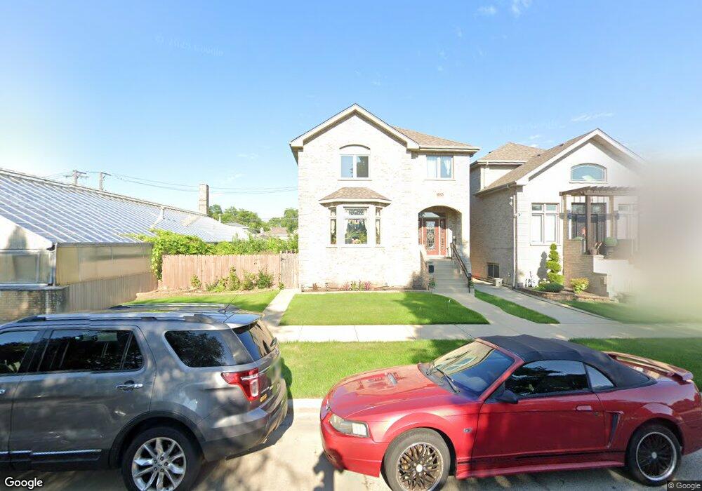
5324 S Mason Ave Chicago, IL 60638
Garfield Ridge NeighborhoodEstimated Value: $652,846 - $794,000
4
Beds
6
Baths
3,309
Sq Ft
$220/Sq Ft
Est. Value
About This Home
This home is located at 5324 S Mason Ave, Chicago, IL 60638 and is currently estimated at $726,462, approximately $219 per square foot. 5324 S Mason Ave is a home located in Cook County with nearby schools including Twain Elementary School, Kennedy High School, and Gloria Dei Lutheran School.
Ownership History
Date
Name
Owned For
Owner Type
Purchase Details
Closed on
Jan 23, 2024
Sold by
Barragan Mia
Bought by
Mia Barragan Trust and Fifth Third Bank Na
Current Estimated Value
Purchase Details
Closed on
Oct 15, 2011
Sold by
Mason Avenue Development Llc
Bought by
Mb Financial Bank
Purchase Details
Closed on
Oct 20, 2006
Sold by
Chicago Title Land Trust Co
Bought by
Mason Avenue Development Llc
Create a Home Valuation Report for This Property
The Home Valuation Report is an in-depth analysis detailing your home's value as well as a comparison with similar homes in the area
Home Values in the Area
Average Home Value in this Area
Purchase History
| Date | Buyer | Sale Price | Title Company |
|---|---|---|---|
| Mia Barragan Trust | -- | None Listed On Document | |
| Fifth Third Bank Na | -- | None Listed On Document | |
| Mb Financial Bank | $480,000 | M G R Title | |
| Mason Avenue Development Llc | -- | None Available |
Source: Public Records
Tax History
| Year | Tax Paid | Tax Assessment Tax Assessment Total Assessment is a certain percentage of the fair market value that is determined by local assessors to be the total taxable value of land and additions on the property. | Land | Improvement |
|---|---|---|---|---|
| 2025 | $9,217 | $62,000 | $6,034 | $55,966 |
| 2024 | $9,217 | $62,000 | $6,034 | $55,966 |
| 2023 | $8,963 | $47,001 | $5,388 | $41,613 |
| 2022 | $8,963 | $47,001 | $5,388 | $41,613 |
| 2021 | $8,781 | $46,999 | $5,387 | $41,612 |
| 2020 | $10,493 | $50,207 | $4,310 | $45,897 |
| 2019 | $10,519 | $55,786 | $4,310 | $51,476 |
| 2018 | $10,341 | $55,786 | $4,310 | $51,476 |
| 2017 | $8,462 | $42,686 | $3,879 | $38,807 |
| 2016 | $8,549 | $42,686 | $3,879 | $38,807 |
| 2015 | $7,822 | $42,686 | $3,879 | $38,807 |
| 2014 | $7,128 | $38,420 | $3,663 | $34,757 |
| 2013 | $6,988 | $38,420 | $3,663 | $34,757 |
Source: Public Records
Map
Nearby Homes
- 5259 S Mason Ave
- 5330 S Mayfield Ave
- 5245 S Mayfield Ave
- 5235 S Monitor Ave
- 6051 S Archer Ave Unit 3B
- 5850 W 55th St Unit 3F
- 5130 S Menard Ave
- 6025 W 55th St
- 5419 S Massasoit Ave Unit 3
- 5807 W 55th St
- 6119 W 55th St
- 5115 S Melvina Ave
- 5221 S Parkside Ave
- 5202 S Central Ave
- 5658 S Austin Ave
- 5418 S Mulligan Ave
- 5711 S Mayfield Ave
- 5723 S Melvina Ave
- 5250 S Nagle Ave
- 6334 S Austin Ave
- 5316 S Mason Ave
- 5324 S Mason Ave
- 5316 S Mason Ave
- 5314 S Mason Ave
- 5314 S Mason Ave
- 5320 S Mason Ave
- 5320 S Mason Ave
- 5310 S Mason Ave
- 5304 S Mason Ave
- 5306 S Mason Ave
- 5321 S Austin Ave
- 5317 S Austin Ave
- 5317 S Austin Ave
- 5325 S Austin Ave
- 5327 S Austin Ave
- 5315 S Mason Ave
- 5315 S Austin Ave
- 5340 S Mason Ave
- 5331 S Austin Ave
- 5309 S Austin Ave
Your Personal Tour Guide
Ask me questions while you tour the home.