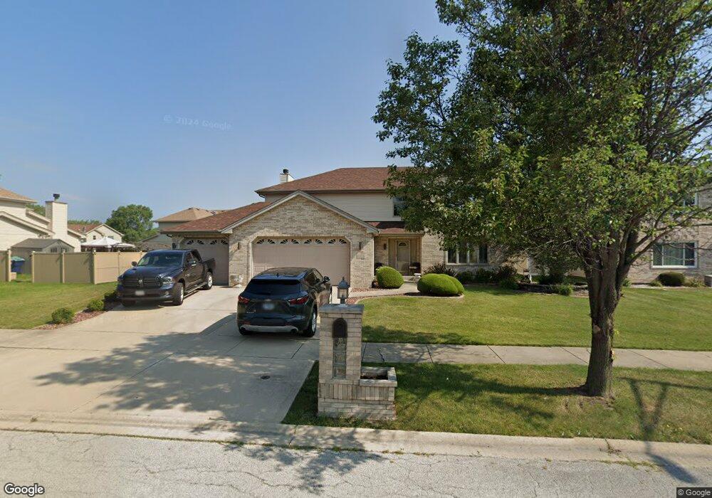
5328 Stanford Ln Matteson, IL 60443
West Matteson NeighborhoodEstimated Value: $354,372 - $421,000
4
Beds
3
Baths
2,540
Sq Ft
$147/Sq Ft
Est. Value
About This Home
This home is located at 5328 Stanford Ln, Matteson, IL 60443 and is currently estimated at $372,843, approximately $146 per square foot. 5328 Stanford Ln is a home located in Cook County with nearby schools including Colin Powell Middle School.
Ownership History
Date
Name
Owned For
Owner Type
Purchase Details
Closed on
May 16, 2001
Sold by
Willis Builders Ltd
Bought by
Pate Sandy and Pate Jacqueline
Current Estimated Value
Home Financials for this Owner
Home Financials are based on the most recent Mortgage that was taken out on this home.
Original Mortgage
$183,920
Outstanding Balance
$94,162
Interest Rate
12.25%
Estimated Equity
$278,681
Purchase Details
Closed on
Dec 5, 2000
Sold by
State Bank Of Countryside
Bought by
Willis Builders Ltd
Create a Home Valuation Report for This Property
The Home Valuation Report is an in-depth analysis detailing your home's value as well as a comparison with similar homes in the area
Home Values in the Area
Average Home Value in this Area
Purchase History
| Date | Buyer | Sale Price | Title Company |
|---|---|---|---|
| Pate Sandy | $231,000 | Chicago Title Insurance Co | |
| Willis Builders Ltd | $39,000 | -- |
Source: Public Records
Mortgage History
| Date | Status | Borrower | Loan Amount |
|---|---|---|---|
| Open | Pate Sandy | $183,920 |
Source: Public Records
Tax History Compared to Growth
Tax History
| Year | Tax Paid | Tax Assessment Tax Assessment Total Assessment is a certain percentage of the fair market value that is determined by local assessors to be the total taxable value of land and additions on the property. | Land | Improvement |
|---|---|---|---|---|
| 2024 | $11,891 | $32,000 | $4,796 | $27,204 |
| 2023 | $9,523 | $32,000 | $4,796 | $27,204 |
| 2022 | $9,523 | $21,208 | $4,142 | $17,066 |
| 2021 | $9,661 | $21,207 | $4,142 | $17,065 |
| 2020 | $9,455 | $21,207 | $4,142 | $17,065 |
| 2019 | $9,075 | $20,038 | $3,706 | $16,332 |
| 2018 | $10,631 | $23,180 | $3,706 | $19,474 |
| 2017 | $10,368 | $23,180 | $3,706 | $19,474 |
| 2016 | $7,156 | $16,326 | $3,270 | $13,056 |
| 2015 | $6,963 | $16,326 | $3,270 | $13,056 |
| 2014 | $6,801 | $16,326 | $3,270 | $13,056 |
| 2013 | $8,264 | $20,593 | $3,270 | $17,323 |
Source: Public Records
Map
Nearby Homes
- 340 Maryview Ct
- 322 Central Ave
- 856 Notre Dame Dr
- 5631 Colgate Ln
- 255 Central Ave
- 829 Princeton Ave
- 246 Owen St
- 202 Owen St
- 912 Princeton Ave
- 192 Owen St
- 953 Dartmouth Ave
- 948 Dartmouth Ave
- 5503 Georgetown Dr
- 175 Owen St
- 5628 Crestwood Rd
- 5808 Allemong Dr
- 970 Regent Dr
- 997 Regent Dr
- 72 Kenneth St
- 312 Grafton Place
- 5320 Stanford Ln
- 5336 Stanford Ln
- 5327 Northwestern Dr
- 5339 Northwestern Dr
- 5319 Stanford Ln
- 5331 Stanford Ln
- 5310 Stanford Ln
- 5325 Stanford Ln
- 5311 Northwestern Dr
- 5317 Stanford Ln
- 5339 Stanford Ln
- 5300 Stanford Ln
- 5362 Northwestern Dr
- 5303 Northwestern Dr
- 5354 Northwestern Dr
- 5346 Northwestern Dr
- 5370 Northwestern Dr
- 5330 Northwestern Dr
- 5338 Northwestern Dr
- 5322 Northwestern Dr