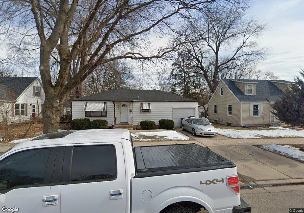
533 Illinois Ave Elgin, IL 60120
Southeast Elgin NeighborhoodEstimated Value: $167,000 - $249,000
--
Bed
--
Bath
768
Sq Ft
$260/Sq Ft
Est. Value
About This Home
This home is located at 533 Illinois Ave, Elgin, IL 60120 and is currently estimated at $199,676, approximately $259 per square foot. 533 Illinois Ave is a home located in Kane County with nearby schools including Huff Elementary School, Ellis Middle School, and Elgin High School.
Ownership History
Date
Name
Owned For
Owner Type
Purchase Details
Closed on
Jan 28, 2022
Sold by
Gabriel Medina Armando
Bought by
Gonzalez Ezequiel
Current Estimated Value
Purchase Details
Closed on
Oct 11, 2021
Sold by
Medina Fernando Manuel
Bought by
Gonzalez Ezequiel
Purchase Details
Closed on
Mar 19, 2019
Sold by
Medina Fenando Mauel
Bought by
Medina Amando Gabriel
Purchase Details
Closed on
Jun 30, 2016
Sold by
Nicoll June M
Bought by
Medina Fernando Manvel
Create a Home Valuation Report for This Property
The Home Valuation Report is an in-depth analysis detailing your home's value as well as a comparison with similar homes in the area
Home Values in the Area
Average Home Value in this Area
Purchase History
| Date | Buyer | Sale Price | Title Company |
|---|---|---|---|
| Gonzalez Ezequiel | -- | Wright Kevin W | |
| Gonzalez Ezequiel | -- | None Available | |
| Medina Amando Gabriel | -- | None Available | |
| Medina Fernando Manvel | $54,000 | Chicago Title Co |
Source: Public Records
Tax History Compared to Growth
Tax History
| Year | Tax Paid | Tax Assessment Tax Assessment Total Assessment is a certain percentage of the fair market value that is determined by local assessors to be the total taxable value of land and additions on the property. | Land | Improvement |
|---|---|---|---|---|
| 2024 | $4,363 | $54,519 | $14,772 | $39,747 |
| 2023 | $4,199 | $49,253 | $13,345 | $35,908 |
| 2022 | $3,894 | $44,910 | $12,168 | $32,742 |
| 2021 | $3,746 | $41,987 | $11,376 | $30,611 |
| 2020 | $3,529 | $38,691 | $10,860 | $27,831 |
| 2019 | $3,442 | $36,856 | $10,345 | $26,511 |
| 2018 | $3,144 | $31,696 | $9,746 | $21,950 |
| 2017 | $3,053 | $29,682 | $9,213 | $20,469 |
| 2016 | $2,937 | $27,537 | $8,547 | $18,990 |
| 2015 | -- | $25,240 | $7,834 | $17,406 |
| 2014 | -- | $24,928 | $7,737 | $17,191 |
| 2013 | -- | $28,699 | $7,941 | $20,758 |
Source: Public Records
Map
Nearby Homes
- 644 Lavoie Ave
- 645 Lavoie Ave
- 628 S Liberty St
- 536 Aller Ave
- 364 Bent St
- 518 Raymond St
- 603 Wellington Ave
- 539 Lucille Ave
- 306 S Liberty St
- 661 Wellington Ave
- 445 Lucile Ave
- 262 Bartlett Place
- 653 Dixon Ave
- 725 Dixon Ave
- 767 Dixon Ave
- 653 Elgin Ave
- 270 Villa St
- 277 Gifford Place
- 72 Harding St
- 527 Ashland Ave
- 529 Illinois Ave
- 537 Illinois Ave
- 543 Illinois Ave
- 523 Illinois Ave
- 532 Lavoie Ave
- 517 Illinois Ave
- 536 Lavoie Ave
- 524 Lavoie Ave
- 540 Lavoie Ave
- 664 May St
- 660 May St
- 668 May St
- 516 Lavoie Ave
- 641 Van Nostrand Place
- 536 Illinois Ave
- 515 Illinois Ave
- 676 May St
- 638 Van Nostrand Place
- 542 Illinois Ave