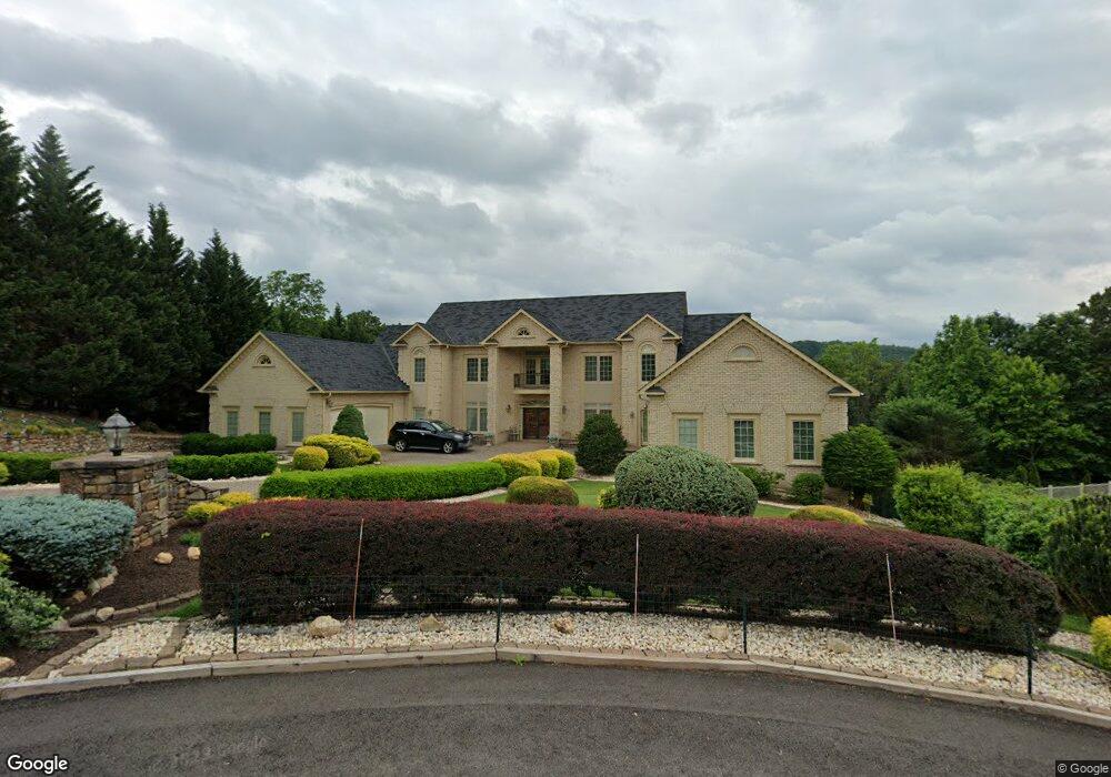
5332 Fox Ridge Rd Roanoke, VA 24018
Cave Spring NeighborhoodEstimated Value: $1,180,000 - $1,323,000
4
Beds
7
Baths
6,832
Sq Ft
$186/Sq Ft
Est. Value
About This Home
This home is located at 5332 Fox Ridge Rd, Roanoke, VA 24018 and is currently estimated at $1,269,601, approximately $185 per square foot. 5332 Fox Ridge Rd is a home located in Roanoke County with nearby schools including Clearbrook Elementary School, Cave Spring Middle School, and Cave Spring High School.
Ownership History
Date
Name
Owned For
Owner Type
Purchase Details
Closed on
Mar 8, 2005
Sold by
Deke Daryl L and Deke Tanya G
Bought by
Glowczynski Walter J and Glowczynski Edith C
Current Estimated Value
Home Financials for this Owner
Home Financials are based on the most recent Mortgage that was taken out on this home.
Original Mortgage
$682,500
Outstanding Balance
$351,952
Interest Rate
5.87%
Mortgage Type
Adjustable Rate Mortgage/ARM
Estimated Equity
$917,649
Create a Home Valuation Report for This Property
The Home Valuation Report is an in-depth analysis detailing your home's value as well as a comparison with similar homes in the area
Home Values in the Area
Average Home Value in this Area
Purchase History
| Date | Buyer | Sale Price | Title Company |
|---|---|---|---|
| Glowczynski Walter J | $975,000 | None Available |
Source: Public Records
Mortgage History
| Date | Status | Borrower | Loan Amount |
|---|---|---|---|
| Open | Glowczynski Walter J | $682,500 |
Source: Public Records
Tax History Compared to Growth
Tax History
| Year | Tax Paid | Tax Assessment Tax Assessment Total Assessment is a certain percentage of the fair market value that is determined by local assessors to be the total taxable value of land and additions on the property. | Land | Improvement |
|---|---|---|---|---|
| 2025 | $12,567 | $1,220,100 | $172,500 | $1,047,600 |
| 2024 | $11,816 | $1,136,200 | $172,500 | $963,700 |
| 2023 | $11,186 | $1,055,300 | $165,000 | $890,300 |
| 2022 | $10,681 | $979,900 | $165,000 | $814,900 |
| 2021 | $10,142 | $930,500 | $150,000 | $780,500 |
| 2020 | $10,053 | $922,300 | $150,000 | $772,300 |
| 2019 | $10,243 | $939,700 | $150,000 | $789,700 |
| 2018 | $9,994 | $926,800 | $150,000 | $776,800 |
| 2017 | $9,994 | $916,900 | $150,000 | $766,900 |
| 2016 | $9,984 | $916,000 | $150,000 | $766,000 |
| 2015 | $10,005 | $917,900 | $150,000 | $767,900 |
| 2014 | $9,905 | $908,700 | $150,000 | $758,700 |
Source: Public Records
Map
Nearby Homes
- 5678 Hunt Camp Rd
- 4217 Berkeley Place Dr
- 5620 Hunt Camp Rd
- 5604 Hunt Camp Rd
- 7150 Pine Ct
- 4215 Campbell View Ln
- 5625 Hunt Camp Rd
- Lot A1C Hunt Camp Rd
- A1B & A1C Hunt Camp Rd
- Lot A1B Hunt Camp Rd
- 5634, 5642 Hunt Camp Rd
- 7313 Maple Ct SW
- 7311 Maple Ct
- 4120 Berkeley Place Dr
- 5590 Hunt Camp Rd
- 5566 Hunt Camp Rd
- 5653 Rockbridge Ct
- 4331 Fox Croft Cir
- 4320 William Ct
- 4210 Hannah Belle Way
- 5324 Fox Ridge Rd
- 5340 Fox Ridge Rd
- 5333 Fox Ridge Rd
- 5316 Fox Ridge Rd
- 5341 Fox Ridge Rd
- 5317 Fox Ridge Rd
- 5308 Fox Ridge Rd
- 0 S Mountain Dr Unit 898957
- 0 S Mountain Dr
- 5309 Fox Ridge Rd
- 5644 S Mountain Dr
- 5692 Hunt Camp Rd
- 4419 Buck Mountain Rd
- 5300 Fox Ridge Rd
- 5301 Fox Ridge Rd SW
- 5309 Fox Den Rd
- 5301 Fox Ridge Rd
- 5630 S Mountain Dr
- 5315 Fox Den Rd
- 5637 S Mountain Dr