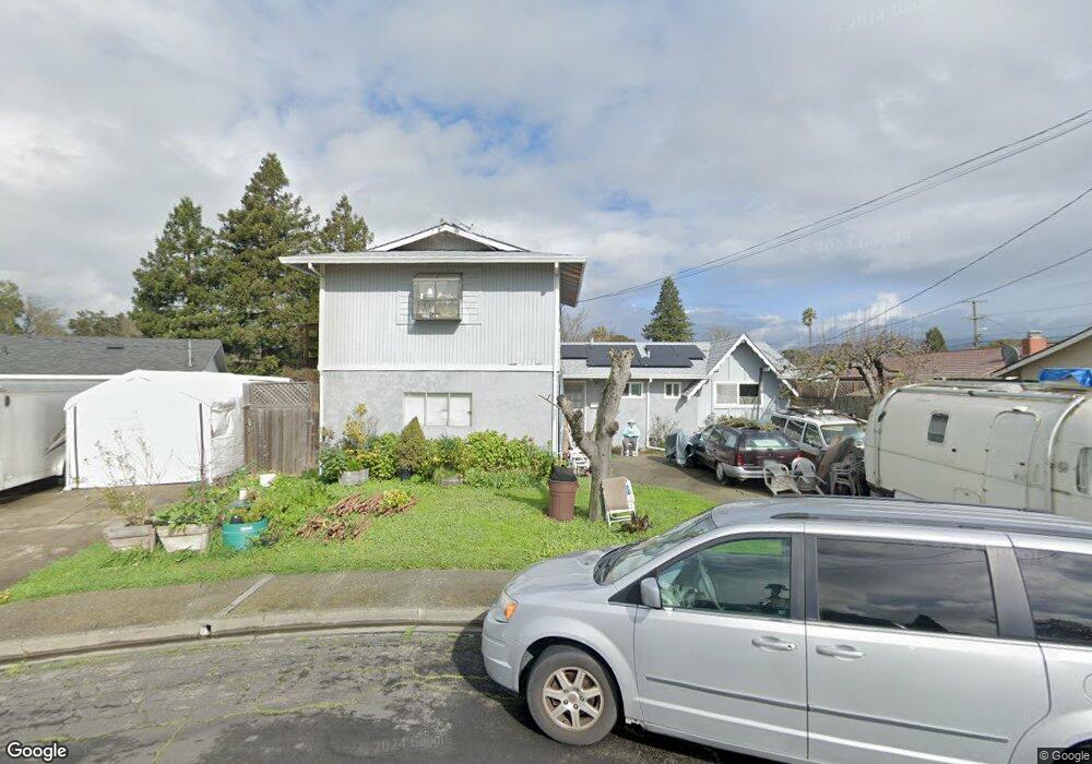
534 Anson Ct Rohnert Park, CA 94928
Estimated Value: $706,000 - $760,000
3
Beds
2
Baths
1,640
Sq Ft
$443/Sq Ft
Est. Value
About This Home
This home is located at 534 Anson Ct, Rohnert Park, CA 94928 and is currently estimated at $726,201, approximately $442 per square foot. 534 Anson Ct is a home located in Sonoma County with nearby schools including Rancho Cotate High School, Cross & Crown Lutheran School, and Bridghaven.
Ownership History
Date
Name
Owned For
Owner Type
Purchase Details
Closed on
Nov 2, 1995
Sold by
Lendrum Earl C and Lendrum Betty J
Bought by
Friedman Alan Wayne and Friedman Barbara Ann
Current Estimated Value
Home Financials for this Owner
Home Financials are based on the most recent Mortgage that was taken out on this home.
Original Mortgage
$139,300
Interest Rate
7.19%
Purchase Details
Closed on
Sep 7, 1990
Bought by
Friedman Alan Wayne and Barbara Ann
Create a Home Valuation Report for This Property
The Home Valuation Report is an in-depth analysis detailing your home's value as well as a comparison with similar homes in the area
Home Values in the Area
Average Home Value in this Area
Purchase History
| Date | Buyer | Sale Price | Title Company |
|---|---|---|---|
| Friedman Alan Wayne | $133,000 | Fidelity National Title | |
| Friedman Alan Wayne | $177,000 | -- |
Source: Public Records
Mortgage History
| Date | Status | Borrower | Loan Amount |
|---|---|---|---|
| Previous Owner | Friedman Alan Wayne | $139,300 |
Source: Public Records
Tax History Compared to Growth
Tax History
| Year | Tax Paid | Tax Assessment Tax Assessment Total Assessment is a certain percentage of the fair market value that is determined by local assessors to be the total taxable value of land and additions on the property. | Land | Improvement |
|---|---|---|---|---|
| 2025 | $3,623 | $319,223 | $126,244 | $192,979 |
| 2024 | $3,623 | $312,965 | $123,769 | $189,196 |
| 2023 | $3,623 | $306,830 | $121,343 | $185,487 |
| 2022 | $3,549 | $300,814 | $118,964 | $181,850 |
| 2021 | $3,519 | $294,917 | $116,632 | $178,285 |
| 2020 | $3,582 | $293,049 | $115,437 | $177,612 |
| 2019 | $3,535 | $287,327 | $113,174 | $174,153 |
| 2018 | $3,466 | $281,716 | $110,955 | $170,761 |
| 2017 | $3,405 | $276,111 | $108,780 | $167,331 |
| 2016 | $3,300 | $273,948 | $106,648 | $167,300 |
| 2015 | $3,219 | $269,899 | $105,047 | $164,852 |
| 2014 | $3,196 | $264,697 | $102,990 | $161,707 |
Source: Public Records
Map
Nearby Homes
- 530 Anson Ct
- 566 Santa Alicia Dr
- 7301 Willlowglen Dr
- 7316 Willowglen Dr
- 478 Santa Alicia Dr
- 77 Walnut Cir
- 138 Walnut Cir
- 746 Bernadette Ave
- 211 Apple Ln
- 6440 Country Club Dr
- 7530 Bernice Ave
- 229 Arlen Dr
- 950 Santa Alicia Dr
- 6469 Meadow Pines Ave
- 928 Civic Center Dr
- 21 Avram Ave
- 7449 Adrian Dr
- 11 Avram Ave
- 1022 Civic Center Dr Unit 33
- 6454 Amberwood St
- 542 Anson Ave
- 538 Anson Ave
- 546 Anson Ave
- 569 Santa Alicia Dr
- 565 Santa Alicia Dr
- 561 Santa Alicia Dr
- 573 Santa Alicia Dr
- 560 Anson Ave
- 559 Santa Alicia Dr
- 524 Anson Ct
- 512 Anson Ave
- 577 Santa Alicia Dr
- 555 Santa Alicia Dr
- 564 Anson Ave
- 520 Anson Ct
- 516 Anson Ct
- 543 Anson Ave
- 539 Anson Ave
- 523 Anson Ave
- 547 Anson Ave