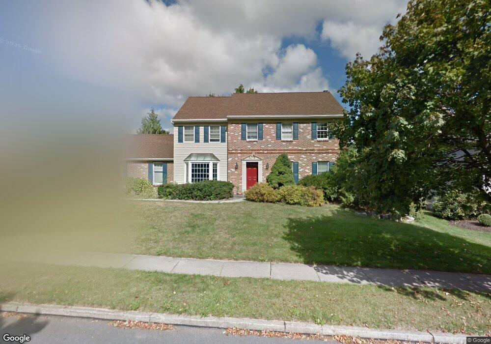
5341 Celia Dr Allentown, PA 18106
Estimated Value: $500,973 - $557,000
4
Beds
3
Baths
2,324
Sq Ft
$225/Sq Ft
Est. Value
About This Home
This home is located at 5341 Celia Dr, Allentown, PA 18106 and is currently estimated at $522,243, approximately $224 per square foot. 5341 Celia Dr is a home located in Lehigh County with nearby schools including Wescosville Elementary School, Lower Macungie Middle School, and Emmaus High School.
Ownership History
Date
Name
Owned For
Owner Type
Purchase Details
Closed on
Sep 8, 2006
Sold by
Lesusky Francis M and Lesusky Carol M
Bought by
Kern Ryan M and Kern Megan M
Current Estimated Value
Home Financials for this Owner
Home Financials are based on the most recent Mortgage that was taken out on this home.
Original Mortgage
$256,000
Outstanding Balance
$153,067
Interest Rate
6.59%
Mortgage Type
Purchase Money Mortgage
Estimated Equity
$369,176
Purchase Details
Closed on
Aug 28, 1985
Bought by
Lesusky Francis M and Lesusky Carol M
Purchase Details
Closed on
May 11, 1984
Sold by
Krawitz and Brill Equity
Bought by
Mirth Thomas A and Mirth Deborah L
Purchase Details
Closed on
Aug 31, 1976
Bought by
Krawitz and Brill Equity
Create a Home Valuation Report for This Property
The Home Valuation Report is an in-depth analysis detailing your home's value as well as a comparison with similar homes in the area
Home Values in the Area
Average Home Value in this Area
Purchase History
| Date | Buyer | Sale Price | Title Company |
|---|---|---|---|
| Kern Ryan M | $320,000 | None Available | |
| Lesusky Francis M | $118,000 | -- | |
| Mirth Thomas A | $1,170,000 | -- | |
| Krawitz | -- | -- |
Source: Public Records
Mortgage History
| Date | Status | Borrower | Loan Amount |
|---|---|---|---|
| Open | Kern Ryan M | $256,000 |
Source: Public Records
Tax History Compared to Growth
Tax History
| Year | Tax Paid | Tax Assessment Tax Assessment Total Assessment is a certain percentage of the fair market value that is determined by local assessors to be the total taxable value of land and additions on the property. | Land | Improvement |
|---|---|---|---|---|
| 2025 | $6,209 | $243,200 | $34,900 | $208,300 |
| 2024 | $6,007 | $243,200 | $34,900 | $208,300 |
| 2023 | $5,887 | $243,200 | $34,900 | $208,300 |
| 2022 | $5,748 | $243,200 | $208,300 | $34,900 |
| 2021 | $5,626 | $243,200 | $34,900 | $208,300 |
| 2020 | $5,572 | $243,200 | $34,900 | $208,300 |
| 2019 | $5,477 | $243,200 | $34,900 | $208,300 |
| 2018 | $5,405 | $243,200 | $34,900 | $208,300 |
| 2017 | $5,311 | $243,200 | $34,900 | $208,300 |
| 2016 | -- | $243,200 | $34,900 | $208,300 |
| 2015 | -- | $243,200 | $34,900 | $208,300 |
| 2014 | -- | $243,200 | $34,900 | $208,300 |
Source: Public Records
Map
Nearby Homes
- 5300 Hanover Dr
- 997 Village Round Unit K
- 997K Village Round Unit 104K
- 1037 Village Round Unit L
- 1385 Brookside Rd
- 5524 Stonecroft Ln
- 5673 Wedge Ln
- 5475 Hamilton Blvd Unit 7
- 5619 Stonecroft Ln
- 5736 Greens Dr
- 4881 Spruce Rd
- 5133 Meadow Ln
- 5280 Townsquare Dr
- 1675 Hamlet Dr
- 1270 Minesite Rd
- 4626 N Hedgerow Dr
- 1045 Barnside Rd
- 5175 Meadowview Dr
- 6007 Timberknoll Dr
- 1991 Autumn Ridge Rd