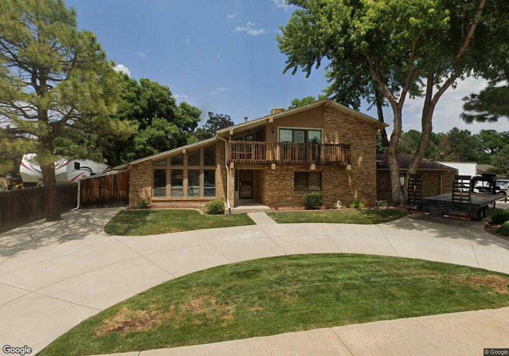
5341 Cole Cir Arvada, CO 80002
Appleridge Estates NeighborhoodEstimated Value: $786,712 - $937,000
4
Beds
5
Baths
2,273
Sq Ft
$388/Sq Ft
Est. Value
About This Home
This home is located at 5341 Cole Cir, Arvada, CO 80002 and is currently estimated at $881,928, approximately $388 per square foot. 5341 Cole Cir is a home located in Jefferson County with nearby schools including Fairmount Elementary School, Drake Junior High School, and Arvada West High School.
Ownership History
Date
Name
Owned For
Owner Type
Purchase Details
Closed on
May 23, 2022
Sold by
Grunden George L
Bought by
Grunden George L and Grunden Family Trust
Current Estimated Value
Purchase Details
Closed on
Feb 8, 2022
Sold by
Grunden Renza M
Bought by
Grunden George L
Purchase Details
Closed on
Jun 18, 1999
Sold by
Dean Kleinkopf M and Dean Nancy E
Bought by
Grunden George L and Grunden Renza M
Home Financials for this Owner
Home Financials are based on the most recent Mortgage that was taken out on this home.
Original Mortgage
$223,200
Interest Rate
7.02%
Purchase Details
Closed on
Jun 27, 1996
Sold by
Palmer Jerald D and Palmer Rosann
Bought by
Kleinkopf M Dean and Kleinkopf Nancy E
Home Financials for this Owner
Home Financials are based on the most recent Mortgage that was taken out on this home.
Original Mortgage
$172,350
Interest Rate
5.8%
Create a Home Valuation Report for This Property
The Home Valuation Report is an in-depth analysis detailing your home's value as well as a comparison with similar homes in the area
Home Values in the Area
Average Home Value in this Area
Purchase History
| Date | Buyer | Sale Price | Title Company |
|---|---|---|---|
| Grunden George L | -- | None Listed On Document | |
| Grunden George L | -- | None Listed On Document | |
| Grunden George L | $279,900 | Land Title | |
| Kleinkopf M Dean | $191,500 | Land Title |
Source: Public Records
Mortgage History
| Date | Status | Borrower | Loan Amount |
|---|---|---|---|
| Previous Owner | Grunden George L | $223,200 | |
| Previous Owner | Kleinkopf M Dean | $172,350 |
Source: Public Records
Tax History Compared to Growth
Tax History
| Year | Tax Paid | Tax Assessment Tax Assessment Total Assessment is a certain percentage of the fair market value that is determined by local assessors to be the total taxable value of land and additions on the property. | Land | Improvement |
|---|---|---|---|---|
| 2024 | $4,160 | $44,633 | $13,308 | $31,325 |
| 2023 | $4,160 | $44,633 | $13,308 | $31,325 |
| 2022 | $3,714 | $39,280 | $10,596 | $28,684 |
| 2021 | $3,780 | $40,410 | $10,901 | $29,509 |
| 2020 | $4,095 | $42,814 | $12,798 | $30,016 |
| 2019 | $3,949 | $42,814 | $12,798 | $30,016 |
| 2018 | $2,935 | $30,821 | $10,615 | $20,206 |
| 2017 | $2,680 | $30,821 | $10,615 | $20,206 |
| 2016 | $2,376 | $25,623 | $6,280 | $19,343 |
| 2015 | $2,275 | $25,623 | $6,280 | $19,343 |
| 2014 | $2,275 | $23,928 | $5,731 | $18,197 |
Source: Public Records
Map
Nearby Homes
- 14290 W 54th Ave
- 5287 Flora Way
- 5282 Yank Way
- 14185 W 50th Ave
- 14195 W 50th Ave
- 5726 Fig Ct
- 12321 W 58th Dr
- 4875 Eldridge St
- 5683 Fig Way
- 14417 W 57th Place
- 13030 W 58th Ave
- 14238 W 58th Place
- 5773 Yank St
- 5256 Flora Way
- 5316 Flora Way
- 5286 Flora Way
- 5266 Flora Way
- 5555 Ward Rd
- 4822 Flora Ct
- 14993 W 55th Dr