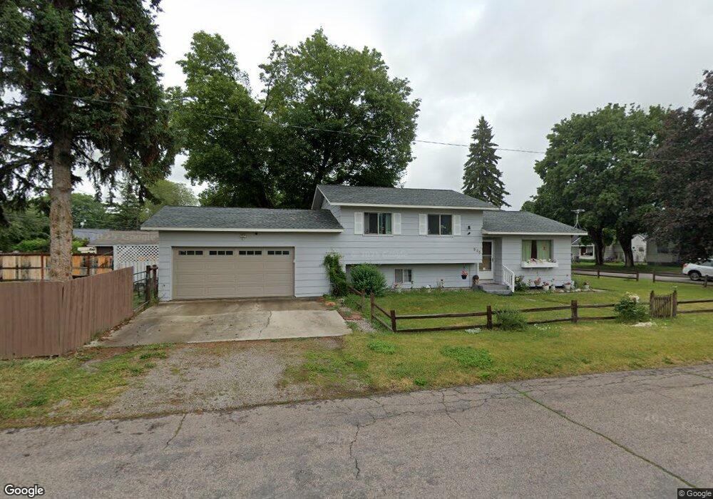
535 12th St E Kalispell, MT 59901
Estimated Value: $413,000 - $472,000
4
Beds
2
Baths
1,560
Sq Ft
$285/Sq Ft
Est. Value
About This Home
This home is located at 535 12th St E, Kalispell, MT 59901 and is currently estimated at $444,062, approximately $284 per square foot. 535 12th St E is a home located in Flathead County with nearby schools including Cornelius Hedges School, Kalispell Middle School, and Flathead High School.
Ownership History
Date
Name
Owned For
Owner Type
Purchase Details
Closed on
Oct 12, 2017
Sold by
Sullivan Sharon and Sullivan William S
Bought by
Virnig Ronald Edward and Virnig Dana Marie
Current Estimated Value
Home Financials for this Owner
Home Financials are based on the most recent Mortgage that was taken out on this home.
Original Mortgage
$207,070
Outstanding Balance
$172,962
Interest Rate
3.82%
Mortgage Type
New Conventional
Estimated Equity
$271,100
Purchase Details
Closed on
Dec 18, 2008
Sold by
Brundy Allison and Brundy Curtis
Bought by
Sullivan William S and Sullivan Joyce L
Home Financials for this Owner
Home Financials are based on the most recent Mortgage that was taken out on this home.
Original Mortgage
$144,000
Interest Rate
6.03%
Mortgage Type
New Conventional
Create a Home Valuation Report for This Property
The Home Valuation Report is an in-depth analysis detailing your home's value as well as a comparison with similar homes in the area
Purchase History
| Date | Buyer | Sale Price | Title Company |
|---|---|---|---|
| Virnig Ronald Edward | -- | None Available | |
| Sullivan William S | -- | Insured Titles |
Source: Public Records
Mortgage History
| Date | Status | Borrower | Loan Amount |
|---|---|---|---|
| Open | Virnig Ronald Edward | $207,070 | |
| Previous Owner | Sullivan William S | $144,000 |
Source: Public Records
Tax History Compared to Growth
Tax History
| Year | Tax Paid | Tax Assessment Tax Assessment Total Assessment is a certain percentage of the fair market value that is determined by local assessors to be the total taxable value of land and additions on the property. | Land | Improvement |
|---|---|---|---|---|
| 2025 | $1,984 | $407,300 | $0 | $0 |
| 2024 | $2,602 | $334,100 | $0 | $0 |
| 2023 | $3,035 | $334,100 | $0 | $0 |
| 2022 | $2,440 | $242,900 | $0 | $0 |
| 2021 | $2,614 | $242,900 | $0 | $0 |
| 2020 | $2,508 | $191,300 | $0 | $0 |
| 2019 | $2,516 | $191,300 | $0 | $0 |
| 2018 | $2,334 | $167,300 | $0 | $0 |
| 2017 | $2,339 | $167,300 | $0 | $0 |
| 2016 | $1,969 | $150,500 | $0 | $0 |
| 2015 | $1,966 | $150,500 | $0 | $0 |
| 2014 | $1,995 | $92,220 | $0 | $0 |
Source: Public Records
Map
Nearby Homes
- 1403 & 1405 4th Ave E
- 826 11th St E
- 835 7th Ave E
- 1225 2nd Ave E
- 1024 Woodland Ave
- 1312 2nd Ave E
- 723 5th Ave E Unit 212C
- 1227 1st Ave E
- 51 Selders Ln
- 776 1st Ave E
- 1687 Bull Run
- 442 4th Ave E
- 1692 Bull Run
- 529 1st Ave E
- 270 Caroline Rd
- 209 12th St W
- 220 Zimmerman Rd
- 1028 2nd Ave W
- 1717 S Woodland Dr Unit SPC -21
- 348 College Ave Unit 8