Estimated Value: $209,538 - $256,000
3
Beds
2
Baths
1,272
Sq Ft
$182/Sq Ft
Est. Value
About This Home
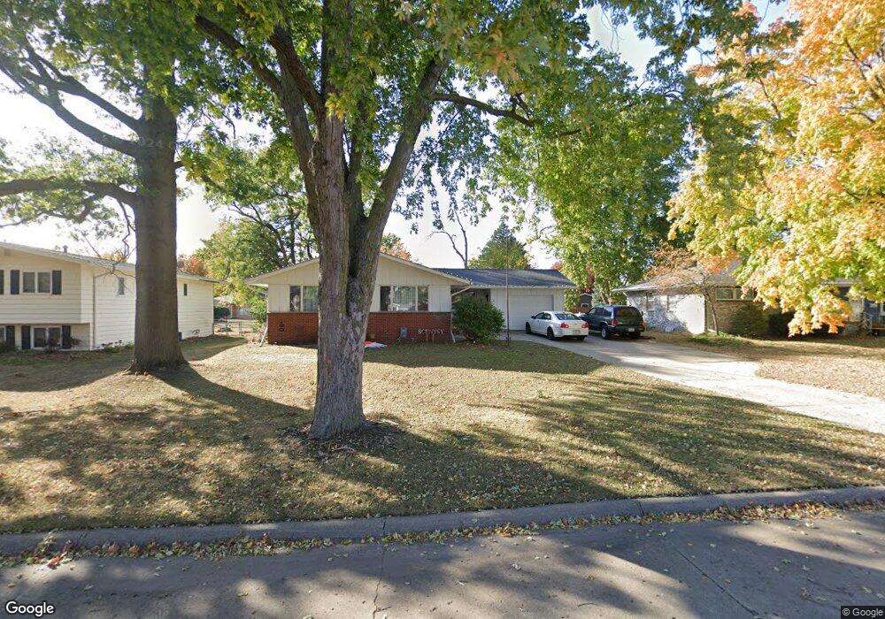
This home is located at 535 Linden Ln, Boone, IA 50036 and is currently estimated at $231,135, approximately $181 per square foot. 535 Linden Ln is a home located in Boone County with nearby schools including Boone High School, Sacred Heart School, and Trinity Lutheran School.
Ownership History
Date
Name
Owned For
Owner Type
Purchase Details
Closed on
Mar 24, 2025
Sold by
Liberty Fund Llc
Bought by
Liberty Property Holdings Llc
Current Estimated Value
Home Financials for this Owner
Home Financials are based on the most recent Mortgage that was taken out on this home.
Original Mortgage
$1,889,100
Outstanding Balance
$1,879,222
Interest Rate
6.76%
Mortgage Type
Credit Line Revolving
Estimated Equity
-$1,648,087
Purchase Details
Closed on
Jul 16, 2020
Sold by
Berge Betty L
Bought by
Liberty Fund Llc
Create a Home Valuation Report for This Property
The Home Valuation Report is an in-depth analysis detailing your home's value as well as a comparison with similar homes in the area
Home Values in the Area
Average Home Value in this Area
Purchase History
| Date | Buyer | Sale Price | Title Company |
|---|---|---|---|
| Liberty Property Holdings Llc | -- | None Listed On Document | |
| Liberty Property Holdings Llc | -- | None Listed On Document | |
| Liberty Fund Llc | $80,000 | None Available |
Source: Public Records
Mortgage History
| Date | Status | Borrower | Loan Amount |
|---|---|---|---|
| Open | Liberty Property Holdings Llc | $1,889,100 | |
| Closed | Liberty Property Holdings Llc | $1,889,100 |
Source: Public Records
Tax History
| Year | Tax Paid | Tax Assessment Tax Assessment Total Assessment is a certain percentage of the fair market value that is determined by local assessors to be the total taxable value of land and additions on the property. | Land | Improvement |
|---|---|---|---|---|
| 2025 | $3,244 | $210,070 | $49,390 | $160,680 |
| 2024 | $3,244 | $176,098 | $35,280 | $140,818 |
| 2023 | $3,058 | $176,098 | $35,280 | $140,818 |
| 2022 | $3,178 | $146,291 | $17,640 | $128,651 |
| 2021 | $3,178 | $146,291 | $17,640 | $128,651 |
| 2020 | $3,094 | $147,741 | $17,640 | $130,101 |
| 2019 | $2,992 | $147,741 | $17,640 | $130,101 |
| 2018 | $2,962 | $138,076 | $0 | $0 |
| 2017 | $2,962 | $126,755 | $17,640 | $109,115 |
| 2016 | $2,634 | $126,755 | $17,640 | $109,115 |
| 2015 | $2,642 | $126,755 | $0 | $0 |
| 2014 | $2,556 | $126,755 | $0 | $0 |
Source: Public Records
Map
Nearby Homes
- 538 Linden Ln
- 911 S Jackson St
- 441 S Linn St
- 1208 Garst Ave
- 1311 Union St
- 1615 Hancock Dr
- 204 S Benton St
- 121 Clinton St
- 929 S Jackson St
- 1119 Garst Ave
- 1122 Country Club Dr
- 210 S Tama St
- 203 Linn St
- 104 Tama St
- 1604 Mamie Eisenhower Ave
- 1632 Mamie Eisenhower Ave
- 127 Tama St
- 927 S Marshall St
- 1633 Crestwood Dr
- 107 Marshall St
Your Personal Tour Guide
Ask me questions while you tour the home.