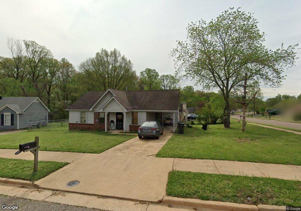
5352 Cornstalk Cove Memphis, TN 38127
Estimated Value: $82,474 - $116,000
3
Beds
1
Bath
1,125
Sq Ft
$89/Sq Ft
Est. Value
About This Home
This home is located at 5352 Cornstalk Cove, Memphis, TN 38127 and is currently estimated at $99,619, approximately $88 per square foot. 5352 Cornstalk Cove is a home located in Shelby County with nearby schools including Northaven Elementary School, Woodstock Middle School, and Trezevant High School.
Ownership History
Date
Name
Owned For
Owner Type
Purchase Details
Closed on
Apr 26, 2011
Sold by
Federal Home Loan Mortgage Corporation
Bought by
Mcclendon Albert L and Mcclendon Sheila A
Current Estimated Value
Purchase Details
Closed on
Mar 11, 2011
Sold by
Brackeen Loyde Wayne and Brackeen Billie
Bought by
Federal Home Loan Mortgage Corp
Purchase Details
Closed on
Nov 18, 2002
Sold by
Steve Yeager Lp
Bought by
Brackeen Loyde Wayne and Brackeen Billie
Home Financials for this Owner
Home Financials are based on the most recent Mortgage that was taken out on this home.
Original Mortgage
$54,000
Interest Rate
6.07%
Purchase Details
Closed on
Dec 21, 1995
Sold by
Yeager Steven J
Bought by
Steve Yeager Lp
Create a Home Valuation Report for This Property
The Home Valuation Report is an in-depth analysis detailing your home's value as well as a comparison with similar homes in the area
Purchase History
| Date | Buyer | Sale Price | Title Company |
|---|---|---|---|
| Mcclendon Albert L | $19,200 | Servicelink Hopewell Campus | |
| Federal Home Loan Mortgage Corp | $18,000 | None Available | |
| Brackeen Loyde Wayne | $60,000 | First American Title Ins Co | |
| Steve Yeager Lp | -- | -- |
Source: Public Records
Mortgage History
| Date | Status | Borrower | Loan Amount |
|---|---|---|---|
| Previous Owner | Brackeen Loyde Wayne | $54,000 |
Source: Public Records
Tax History
| Year | Tax Paid | Tax Assessment Tax Assessment Total Assessment is a certain percentage of the fair market value that is determined by local assessors to be the total taxable value of land and additions on the property. | Land | Improvement |
|---|---|---|---|---|
| 2025 | -- | $21,150 | $2,000 | $19,150 |
| 2024 | $424 | $12,500 | $1,475 | $11,025 |
| 2023 | $424 | $12,500 | $1,475 | $11,025 |
| 2022 | $424 | $12,500 | $1,475 | $11,025 |
| 2021 | $431 | $12,500 | $1,475 | $11,025 |
| 2020 | $365 | $9,000 | $1,475 | $7,525 |
| 2019 | $365 | $9,000 | $1,475 | $7,525 |
| 2018 | $365 | $9,000 | $1,475 | $7,525 |
| 2017 | $370 | $9,000 | $1,475 | $7,525 |
| 2016 | $447 | $10,225 | $0 | $0 |
| 2014 | $447 | $10,225 | $0 | $0 |
Source: Public Records
Map
Nearby Homes
- 5328 Clinchport Cir
- 5410 Cedar Bluff Dr
- 5260 Cedar Bluff Dr
- 5320 Plover Dr
- 5323 Plover Dr
- 5423 Breckenwood Dr
- 837 Pitney Ln
- 5207 Breckenwood Dr
- 5378 Beaverton Dr
- 5267 Broken Oak Dr
- 5319 Braden Dr
- 759 Brandywine Blvd
- 5315 Braden Dr
- 5186 Broken Oak Dr
- 5088 Breckenwood Dr
- 5235 Braden Dr
- 691 Creekstone Cir
- 5090 Belfast Dr
- 5192 Braden Dr
- 5083 Carterville Place
- 5338 Cedar Bluff Dr
- 5356 Cornstalk Cove
- 5332 Cedar Bluff Dr
- 5353 Cornstalk Cove
- 5360 Cornstalk Cove
- 5343 Cedar Bluff Dr
- 5339 Cedar Bluff Dr
- 5351 Cedar Bluff Dr
- 5363 Cornstalk Cove
- 5326 Cedar Bluff Dr
- 5331 Cedar Bluff Dr
- 5364 Cornstalk Cove
- 5355 Cedar Bluff Dr
- 5325 Cedar Bluff Dr
- 5369 Cornstalk Cove
- 5320 Cedar Bluff Dr
- 5368 Cornstalk Cove
- 5361 Cedar Bluff Dr
- 5334 Clinchport Cir
- 5319 Cedar Bluff Dr
Your Personal Tour Guide
Ask me questions while you tour the home.