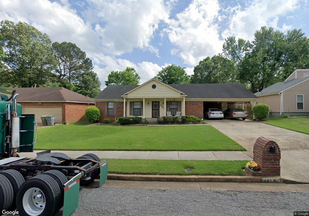
5357 Bruton Ave Memphis, TN 38135
Estimated Value: $188,000 - $210,000
3
Beds
2
Baths
1,657
Sq Ft
$119/Sq Ft
Est. Value
About This Home
This home is located at 5357 Bruton Ave, Memphis, TN 38135 and is currently estimated at $197,077, approximately $118 per square foot. 5357 Bruton Ave is a home located in Shelby County with nearby schools including Brownsville Rd Elementary School, Craigmont Middle School, and Craigmont High School.
Ownership History
Date
Name
Owned For
Owner Type
Purchase Details
Closed on
Jul 15, 2025
Sold by
Crawford Barbara
Bought by
Crawford James M
Current Estimated Value
Purchase Details
Closed on
Oct 20, 2004
Sold by
Daniels Patrick A
Bought by
Hud
Purchase Details
Closed on
Jun 13, 2000
Sold by
Nick Charles K and Nick Gwyn W
Bought by
Daniels Patrick A
Home Financials for this Owner
Home Financials are based on the most recent Mortgage that was taken out on this home.
Original Mortgage
$84,850
Interest Rate
8.55%
Mortgage Type
FHA
Create a Home Valuation Report for This Property
The Home Valuation Report is an in-depth analysis detailing your home's value as well as a comparison with similar homes in the area
Home Values in the Area
Average Home Value in this Area
Purchase History
| Date | Buyer | Sale Price | Title Company |
|---|---|---|---|
| Crawford James M | -- | None Listed On Document | |
| Hud | $89,300 | -- | |
| Daniels Patrick A | $85,000 | -- | |
| Daniels Patrick A | $85,000 | -- |
Source: Public Records
Mortgage History
| Date | Status | Borrower | Loan Amount |
|---|---|---|---|
| Previous Owner | Daniels Patrick A | $84,850 |
Source: Public Records
Tax History
| Year | Tax Paid | Tax Assessment Tax Assessment Total Assessment is a certain percentage of the fair market value that is determined by local assessors to be the total taxable value of land and additions on the property. | Land | Improvement |
|---|---|---|---|---|
| 2025 | $1,087 | $46,825 | $5,000 | $41,825 |
| 2024 | $923 | $32,050 | $3,875 | $28,175 |
| 2023 | $1,952 | $32,050 | $3,875 | $28,175 |
| 2022 | $1,952 | $32,050 | $3,875 | $28,175 |
| 2021 | $1,975 | $32,050 | $3,875 | $28,175 |
| 2020 | $1,652 | $22,800 | $3,875 | $18,925 |
| 2019 | $1,652 | $22,800 | $3,875 | $18,925 |
| 2018 | $1,652 | $22,800 | $3,875 | $18,925 |
| 2017 | $937 | $22,800 | $3,875 | $18,925 |
| 2016 | $941 | $21,525 | $0 | $0 |
| 2014 | $941 | $21,525 | $0 | $0 |
Source: Public Records
Map
Nearby Homes
- 3584 Wythe Rd
- 5305 Gloucester Ave
- 5315 Yale Rd
- 3634 Sunnyside St
- 3496 Lynchburg St
- 5445 Pine Oak Ln
- 3442 Wythe Rd
- 5209 Yale Rd
- 5508 Sweetwater Cove
- 3404 Wetherburns Cir Unit 1
- 3507 Chowning Rd
- 3388 Lord Dunmore Cove
- 0 New Brownsville Rd
- 5366 Craigmont Dr
- 3589 Covington Pike Unit 424
- 3589 Covington Pike Unit 201
- 3589 Covington Pike Unit 419
- 3589 Covington Pike Unit 513
- 3589 Covington Pike Unit 222
- 3589 Covington Pike Unit 407
- 5365 Bruton Ave
- 5351 Bruton Ave
- 5356 Albemarle Dr
- 5364 Albemarle Dr
- 5348 Albemarle Dr
- 5373 Bruton Ave
- 5343 Bruton Ave
- 5358 Bruton Ave
- 5350 Bruton Ave
- 5372 Albemarle Dr
- 5364 Bruton Ave
- 5342 Albemarle Dr
- 5344 Bruton Ave
- 5335 Bruton Ave
- 5374 Bruton Ave
- 5381 Bruton Ave
- 5380 Albemarle Dr
- 5334 Albemarle Dr
- 5334 Bruton Ave
- 5355 Gloucester Ave
Your Personal Tour Guide
Ask me questions while you tour the home.