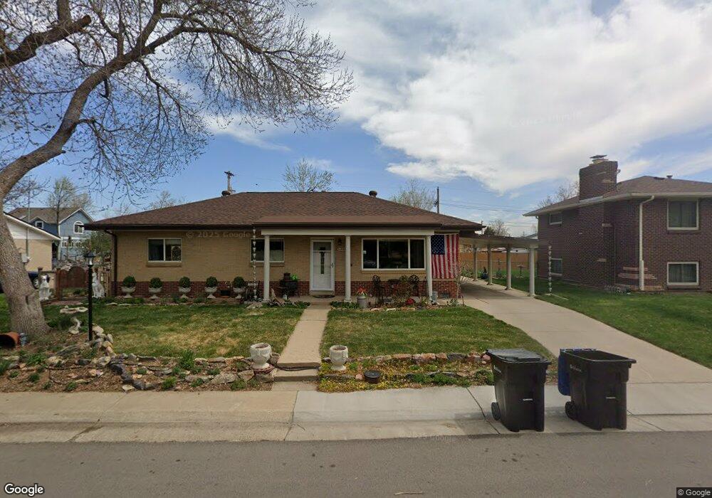
5360 Otis St Arvada, CO 80002
Estimated Value: $506,000 - $560,325
3
Beds
1
Bath
1,380
Sq Ft
$381/Sq Ft
Est. Value
About This Home
This home is located at 5360 Otis St, Arvada, CO 80002 and is currently estimated at $526,331, approximately $381 per square foot. 5360 Otis St is a home located in Jefferson County with nearby schools including Secrest Elementary School, North Arvada Middle School, and Arvada High School.
Ownership History
Date
Name
Owned For
Owner Type
Purchase Details
Closed on
Aug 1, 2015
Sold by
Lawson Robert E and Lawson Carolyn M
Bought by
Capraro Jeri
Current Estimated Value
Home Financials for this Owner
Home Financials are based on the most recent Mortgage that was taken out on this home.
Original Mortgage
$175,000
Outstanding Balance
$137,870
Interest Rate
4.08%
Mortgage Type
New Conventional
Estimated Equity
$388,461
Purchase Details
Closed on
Oct 31, 2000
Sold by
Tia Armbrust Dylan Armbrust
Bought by
Lawson Robert E and Lawson Carolyn M
Home Financials for this Owner
Home Financials are based on the most recent Mortgage that was taken out on this home.
Original Mortgage
$110,000
Interest Rate
7.9%
Mortgage Type
Stand Alone First
Purchase Details
Closed on
Apr 7, 1999
Sold by
Christiansen Tia and Armbrust Dylan
Bought by
Armbrust Dylan and Armbrust Tia
Home Financials for this Owner
Home Financials are based on the most recent Mortgage that was taken out on this home.
Original Mortgage
$123,875
Interest Rate
7.06%
Mortgage Type
FHA
Purchase Details
Closed on
Oct 23, 1997
Sold by
Guildner Janice L
Bought by
Christiansen Tia and Armbrust Dylan
Home Financials for this Owner
Home Financials are based on the most recent Mortgage that was taken out on this home.
Original Mortgage
$118,900
Interest Rate
7.52%
Mortgage Type
FHA
Create a Home Valuation Report for This Property
The Home Valuation Report is an in-depth analysis detailing your home's value as well as a comparison with similar homes in the area
Purchase History
| Date | Buyer | Sale Price | Title Company |
|---|---|---|---|
| Capraro Jeri | $225,000 | Land Title Guarantee Company | |
| Lawson Robert E | $168,000 | Stewart Title | |
| Armbrust Dylan | -- | -- | |
| Christiansen Tia | $120,000 | Land Title |
Source: Public Records
Mortgage History
| Date | Status | Borrower | Loan Amount |
|---|---|---|---|
| Open | Capraro Jeri | $175,000 | |
| Previous Owner | Lawson Robert E | $110,000 | |
| Previous Owner | Armbrust Dylan | $123,875 | |
| Previous Owner | Christiansen Tia | $118,900 |
Source: Public Records
Tax History
| Year | Tax Paid | Tax Assessment Tax Assessment Total Assessment is a certain percentage of the fair market value that is determined by local assessors to be the total taxable value of land and additions on the property. | Land | Improvement |
|---|---|---|---|---|
| 2024 | $3,321 | $33,331 | $14,204 | $19,127 |
| 2023 | $3,321 | $33,331 | $14,204 | $19,127 |
| 2022 | $2,747 | $27,394 | $10,510 | $16,884 |
| 2021 | $2,788 | $28,182 | $10,812 | $17,370 |
| 2020 | $2,513 | $25,434 | $9,358 | $16,076 |
| 2019 | $2,479 | $25,434 | $9,358 | $16,076 |
| 2018 | $2,068 | $20,614 | $6,246 | $14,368 |
| 2017 | $1,895 | $20,614 | $6,246 | $14,368 |
| 2016 | $1,745 | $17,845 | $5,276 | $12,569 |
| 2015 | $1,469 | $17,845 | $5,276 | $12,569 |
| 2014 | $1,469 | $14,122 | $4,872 | $9,250 |
Source: Public Records
Map
Nearby Homes
- 5465 Reed Ct
- 6940 W 55th Place
- 6865 W 55th Place
- 5423 Saulsbury Ct
- 6910 Reno Dr
- 6427 Grandview Ave Unit A & B
- 5716 Saulsbury St
- 6902 Ralston Rd
- 7357 Grandview Ave Unit 202
- 6105 W 49th Place
- 4963 Harlan St
- 7856 W 54th Ave Unit 7856
- 5790 W 51st Ave
- 7221 W 48th Ave
- 5320 Allison St Unit 106
- 4925 Gray St
- 6920 W 48th Ave Unit 6920
- 4730 Pierce St
- 5366 Allison St Unit D
- 7931 W 55th Ave Unit 112
Your Personal Tour Guide
Ask me questions while you tour the home.