Estimated Value: $352,000 - $492,000
3
Beds
2
Baths
2,060
Sq Ft
$208/Sq Ft
Est. Value
About This Home
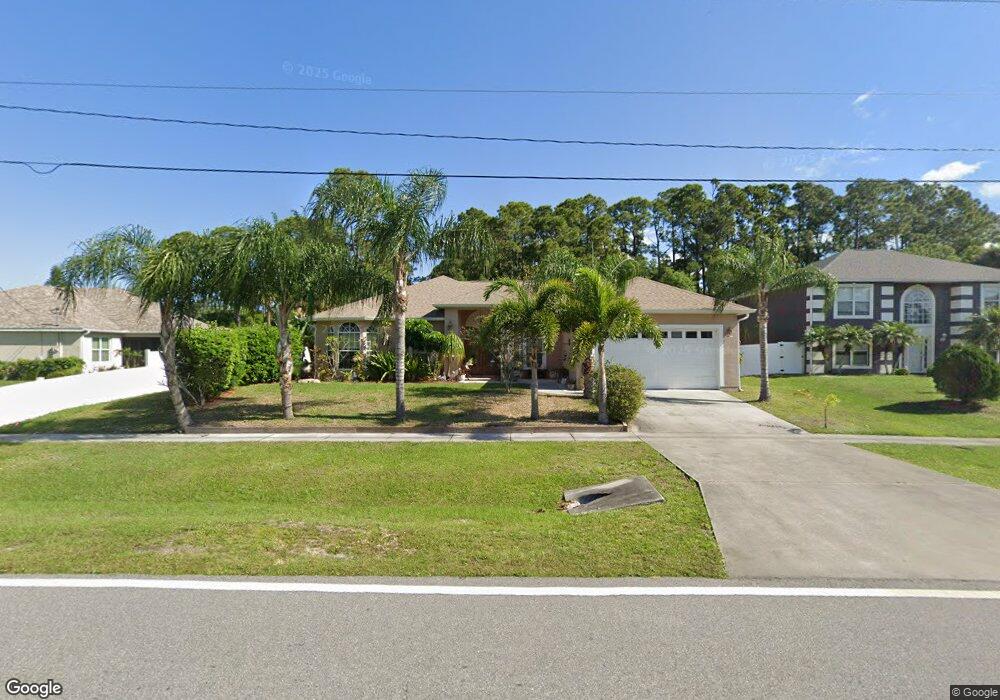
This home is located at 5370 Falcon Blvd, Cocoa, FL 32927 and is currently estimated at $428,116, approximately $207 per square foot. 5370 Falcon Blvd is a home located in Brevard County with nearby schools including Enterprise Elementary School, Space Coast Junior/Senior High School, and Sculptor Charter School.
Ownership History
Date
Name
Owned For
Owner Type
Purchase Details
Closed on
Sep 30, 2020
Sold by
Johnson Dorothy May
Bought by
Johnson Dorothy May and Streefker Alexander R
Current Estimated Value
Purchase Details
Closed on
Jan 7, 2005
Sold by
Corley Thomas and Lyons Paul
Bought by
Johnson Dorothy May
Home Financials for this Owner
Home Financials are based on the most recent Mortgage that was taken out on this home.
Original Mortgage
$187,000
Interest Rate
5.71%
Mortgage Type
Stand Alone First
Purchase Details
Closed on
Jan 12, 2004
Sold by
Lleva E V
Bought by
Corley Thomas and Lyons Paul
Purchase Details
Closed on
Nov 3, 2003
Sold by
Pefanis Stavros F and Pefanis Marina S
Bought by
Lleva E V
Create a Home Valuation Report for This Property
The Home Valuation Report is an in-depth analysis detailing your home's value as well as a comparison with similar homes in the area
Home Values in the Area
Average Home Value in this Area
Purchase History
| Date | Buyer | Sale Price | Title Company |
|---|---|---|---|
| Johnson Dorothy May | -- | None Available | |
| Johnson Dorothy May | $100 | Edson Dorothy | |
| Johnson Dorothy May | $249,900 | Security First Title Partner | |
| Corley Thomas | $29,900 | The Title Station Inc | |
| Lleva E V | $20,000 | The Title Station Inc |
Source: Public Records
Mortgage History
| Date | Status | Borrower | Loan Amount |
|---|---|---|---|
| Previous Owner | Johnson Dorothy May | $187,000 |
Source: Public Records
Tax History
| Year | Tax Paid | Tax Assessment Tax Assessment Total Assessment is a certain percentage of the fair market value that is determined by local assessors to be the total taxable value of land and additions on the property. | Land | Improvement |
|---|---|---|---|---|
| 2025 | $2,122 | $167,420 | -- | -- |
| 2024 | $2,225 | $162,710 | -- | -- |
| 2023 | $2,225 | $157,980 | $0 | $0 |
| 2022 | $2,008 | $147,330 | $0 | $0 |
| 2021 | $2,033 | $143,040 | $0 | $0 |
| 2020 | $1,963 | $141,070 | $0 | $0 |
| 2019 | $1,905 | $137,900 | $0 | $0 |
| 2018 | $1,904 | $135,330 | $0 | $0 |
| 2017 | $1,911 | $132,550 | $0 | $0 |
| 2016 | $1,928 | $129,830 | $18,000 | $111,830 |
| 2015 | $1,966 | $128,930 | $15,000 | $113,930 |
| 2014 | $1,974 | $127,910 | $11,000 | $116,910 |
Source: Public Records
Map
Nearby Homes
- 7230 Venus Ave
- 6990 Bryant Rd
- 7635 Fringe Place
- 5165 Patricia St
- 7065 Hundred Acre Dr
- 5155 Mayflower St
- 7200 Oakwood Ave
- 7545 Fringe Place
- 5150 Melody St
- 5555 Brandon St
- 5200 Frisco St
- 5080 Mayflower St
- 7419 Hackberry Rd
- 7429 Hackberry Rd
- 5075 Carter St
- 7310 Joshua Place
- 6815 Bryant Rd
- 7275 Durban Ave
- 7155 Export Ave
- 5303 Yaupon Holly Dr
- 5360 Falcon Blvd
- 7145 Kaylor Ave
- 7155 Kaylor Ave
- 5350 Falcon Blvd
- 7095 Kaylor Ave
- 5365 Falcon Blvd
- 7165 Kaylor Ave
- 7150 Kaylor Ave
- 5340 Falcon Blvd
- 7085 Kaylor Ave
- 7160 Kaylor Ave
- 7060 Bryant Rd
- 7175 Kaylor Ave
- 5285 Andover St
- 7075 Bryant Rd
- 7170 Kaylor Ave
- 5330 Falcon Blvd
- 7065 Kaylor Ave
- 7080 Kaylor Ave
- 7180 Kaylor Ave
Your Personal Tour Guide
Ask me questions while you tour the home.