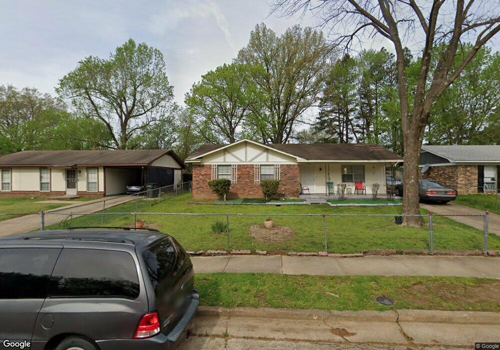
5381 Cornstalk Cove Memphis, TN 38127
Estimated Value: $93,449 - $106,000
3
Beds
1
Bath
1,161
Sq Ft
$88/Sq Ft
Est. Value
About This Home
This home is located at 5381 Cornstalk Cove, Memphis, TN 38127 and is currently estimated at $102,112, approximately $87 per square foot. 5381 Cornstalk Cove is a home located in Shelby County with nearby schools including Northaven Elementary School, Woodstock Middle School, and Trezevant High School.
Ownership History
Date
Name
Owned For
Owner Type
Purchase Details
Closed on
May 11, 2012
Sold by
Douglas Alan Richard and Douglas Christina Laura
Bought by
Equity Trust Company and David Pierick Ira
Current Estimated Value
Purchase Details
Closed on
Mar 19, 2009
Sold by
Us Bank National Association
Bought by
Douglas Alan Richard and Douglas Christina Laura
Purchase Details
Closed on
Dec 15, 2008
Sold by
Jordan Michelle
Bought by
Us Bank National Association
Purchase Details
Closed on
Apr 28, 2006
Sold by
Sweeney Carolyn
Bought by
Jordan Michelle
Home Financials for this Owner
Home Financials are based on the most recent Mortgage that was taken out on this home.
Original Mortgage
$60,000
Interest Rate
10%
Mortgage Type
Fannie Mae Freddie Mac
Create a Home Valuation Report for This Property
The Home Valuation Report is an in-depth analysis detailing your home's value as well as a comparison with similar homes in the area
Home Values in the Area
Average Home Value in this Area
Purchase History
| Date | Buyer | Sale Price | Title Company |
|---|---|---|---|
| Equity Trust Company | $32,500 | None Available | |
| Douglas Alan Richard | $10,000 | None Available | |
| Us Bank National Association | $22,000 | None Available | |
| Jordan Michelle | $60,000 | Lawyers Title Insurance Corp |
Source: Public Records
Mortgage History
| Date | Status | Borrower | Loan Amount |
|---|---|---|---|
| Previous Owner | Jordan Michelle | $60,000 |
Source: Public Records
Tax History Compared to Growth
Tax History
| Year | Tax Paid | Tax Assessment Tax Assessment Total Assessment is a certain percentage of the fair market value that is determined by local assessors to be the total taxable value of land and additions on the property. | Land | Improvement |
|---|---|---|---|---|
| 2025 | $465 | $23,200 | $2,000 | $21,200 |
| 2024 | $465 | $13,725 | $1,475 | $12,250 |
| 2023 | $465 | $13,725 | $1,475 | $12,250 |
| 2022 | $465 | $13,725 | $1,475 | $12,250 |
| 2021 | $474 | $13,725 | $1,475 | $12,250 |
| 2020 | $380 | $9,375 | $1,475 | $7,900 |
| 2019 | $380 | $9,375 | $1,475 | $7,900 |
| 2018 | $380 | $9,375 | $1,475 | $7,900 |
| 2017 | $385 | $9,375 | $1,475 | $7,900 |
| 2016 | $461 | $10,550 | $0 | $0 |
| 2014 | $461 | $10,550 | $0 | $0 |
Source: Public Records
Map
Nearby Homes
- 5387 Cornstalk Cove
- 5371 Cedar Bluff Dr
- 5423 Breckenwood Dr
- 823 Bitter Creek Cove
- 5378 Beaverton Dr
- 5382 Beaverton Dr
- 5315 Braden Dr
- 5096 Belfast Dr
- 5080 Breckenwood Dr
- 5140 Blacksmith Dr
- 645 Mcwhirter Ave
- 5046 Breckenwood Dr
- 936 Chesterton Dr
- 5072 Blacksmith Dr
- 5030 Breckenwood Dr
- 980 N Circle Rd
- 850 Carol Ann Cove
- 766 Fite Rd
- 810 Northaven Dr
- 706 Northaven Dr
- 5375 Cornstalk Cove
- 5369 Cornstalk Cove
- 5386 Cedar Bluff Dr
- 5393 Cornstalk Cove
- 5392 Cedar Bluff Dr
- 5378 Cedar Bluff Dr
- 5370 Cedar Bluff Dr
- 5380 Cornstalk Cove
- 5398 Cedar Bluff Dr
- 5386 Cornstalk Cove
- 5374 Cornstalk Cove
- 5392 Cornstalk Cove
- 5363 Cornstalk Cove
- 5397 Cornstalk Cove
- 5404 Cedar Bluff Dr
- 5368 Cornstalk Cove
- 5396 Cornstalk Cove
- 5353 Cornstalk Cove
- 5401 Cornstalk Cove
- 5364 Cornstalk Cove