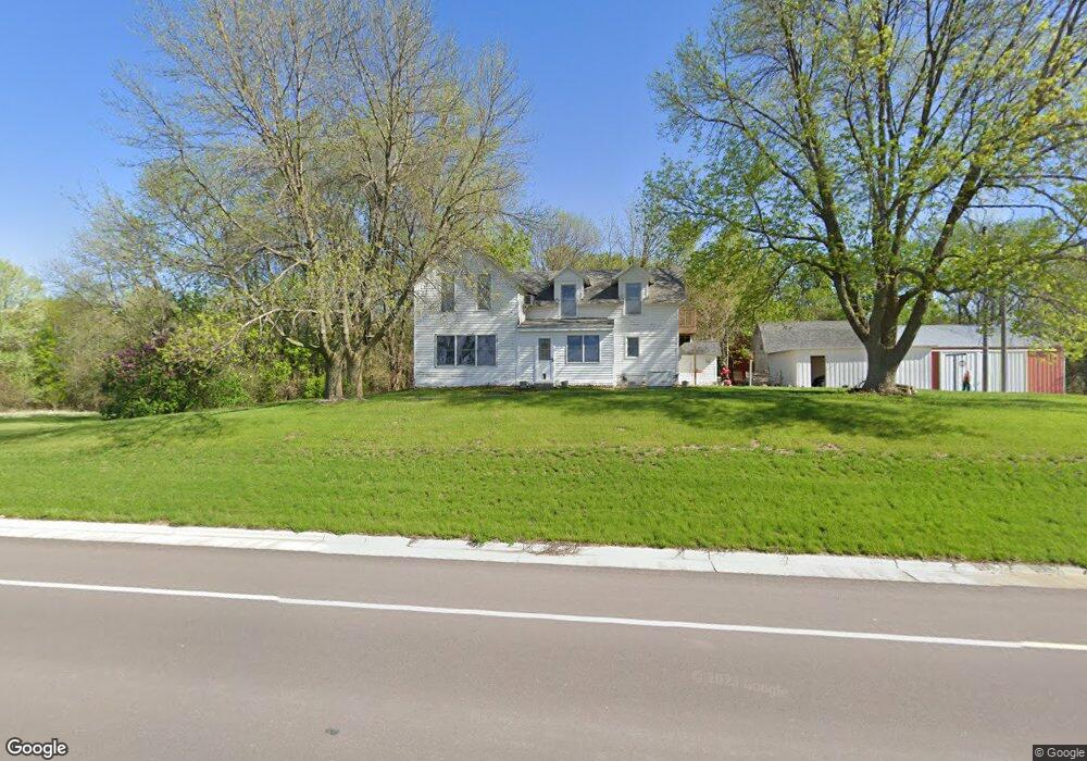
53856 213th St Mankato, MN 56001
Estimated Value: $205,000 - $1,374,976
2
Beds
2
Baths
1,383
Sq Ft
$571/Sq Ft
Est. Value
About This Home
This home is located at 53856 213th St, Mankato, MN 56001 and is currently estimated at $789,988, approximately $571 per square foot. 53856 213th St is a home located in Blue Earth County with nearby schools including Roosevelt Elementary School, Dakota Meadows Middle School, and Mankato West Senior High School.
Ownership History
Date
Name
Owned For
Owner Type
Purchase Details
Closed on
Aug 1, 2020
Sold by
Dackins Gertrude Gertrude
Bought by
Edwards Jay Jay
Current Estimated Value
Home Financials for this Owner
Home Financials are based on the most recent Mortgage that was taken out on this home.
Original Mortgage
$600,000
Outstanding Balance
$532,143
Interest Rate
2.99%
Estimated Equity
$257,845
Create a Home Valuation Report for This Property
The Home Valuation Report is an in-depth analysis detailing your home's value as well as a comparison with similar homes in the area
Home Values in the Area
Average Home Value in this Area
Purchase History
| Date | Buyer | Sale Price | Title Company |
|---|---|---|---|
| Edwards Jay Jay | $600,000 | -- |
Source: Public Records
Mortgage History
| Date | Status | Borrower | Loan Amount |
|---|---|---|---|
| Open | Edwards Jay Jay | $600,000 | |
| Closed | Edwards Jay Jay | -- |
Source: Public Records
Tax History Compared to Growth
Tax History
| Year | Tax Paid | Tax Assessment Tax Assessment Total Assessment is a certain percentage of the fair market value that is determined by local assessors to be the total taxable value of land and additions on the property. | Land | Improvement |
|---|---|---|---|---|
| 2025 | $6,488 | $1,375,300 | $1,253,500 | $121,800 |
| 2024 | $6,488 | $1,505,300 | $1,397,200 | $108,100 |
| 2023 | $5,278 | $1,428,300 | $1,314,700 | $113,600 |
| 2022 | $5,188 | $1,147,900 | $1,044,800 | $103,100 |
| 2021 | $4,772 | $986,200 | $904,700 | $81,500 |
| 2020 | $5,032 | $1,043,100 | $967,800 | $75,300 |
| 2019 | $4,190 | $1,043,100 | $967,800 | $75,300 |
| 2018 | $3,974 | $984,400 | $900,600 | $83,800 |
| 2017 | $4,034 | $1,041,200 | $966,700 | $74,500 |
| 2016 | $4,270 | $1,038,300 | $966,700 | $71,600 |
| 2015 | $45 | $1,082,400 | $1,016,600 | $65,800 |
| 2014 | $3,108 | $111,100 | $50,000 | $61,100 |
Source: Public Records
Map
Nearby Homes
- 0 Tbd S 60 Hwy Unit TBD Highway 60 S
- 419 Royal Rd
- 3202 3202 Noble Dr
- 3111 3111 Scotch Ln
- 42433 Kerns Dr
- 52718 Foxtail Ln
- 52765 409th Ave
- 52618 409th Ave
- 1705 Heritage Dr
- 0 Tbd 421st Ave
- 1701 Heritage Dr
- 1713 Heritage Dr
- 1725 Heritage Dr
- 1709 Heritage Dr
- 1717 Heritage Dr
- 1721 Heritage Dr
- 1700 Heritage Dr
- 1740 Heritage Dr
- 1704 Heritage Dr
- 1708 Heritage Dr
- 53792 213th St
- 53756 213th St
- 54003 213th St
- 54043 State Highway 68
- 54065 State Highway 68
- 53907 State Highway 68
- 54142 213th St
- 54137 State Highway 68
- 54137 Minnesota 68
- 54160 213th St
- 54193 State Highway 68
- 53800 Tbd 211th Ln
- 54190 213th St
- 21207 535th Ave
- 54241 213th St
- 21535 535th Ave
- 21579 535th Ave
- 53804 208th Ln
- 21157 535th Ave
- 54190 Gadwall Rd