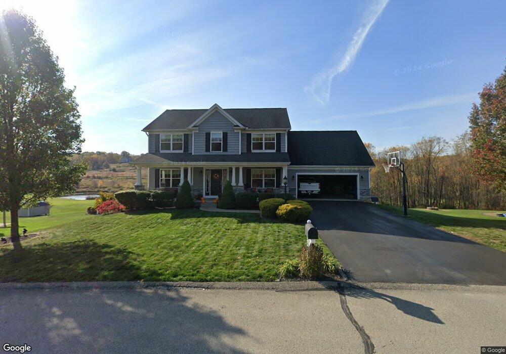
539 Renee Dr Latrobe, PA 15650
Estimated Value: $475,000 - $566,801
--
Bed
--
Bath
2,208
Sq Ft
$228/Sq Ft
Est. Value
About This Home
This home is located at 539 Renee Dr, Latrobe, PA 15650 and is currently estimated at $504,450, approximately $228 per square foot. 539 Renee Dr is a home with nearby schools including Greater Latrobe Junior High School, Greater Latrobe Senior High School, and High Acres School.
Ownership History
Date
Name
Owned For
Owner Type
Purchase Details
Closed on
Oct 26, 2012
Sold by
S & A Homes Inc
Bought by
Slater Robert M and Slater Tracey A
Current Estimated Value
Home Financials for this Owner
Home Financials are based on the most recent Mortgage that was taken out on this home.
Original Mortgage
$277,536
Outstanding Balance
$190,507
Interest Rate
3.25%
Mortgage Type
FHA
Estimated Equity
$313,943
Create a Home Valuation Report for This Property
The Home Valuation Report is an in-depth analysis detailing your home's value as well as a comparison with similar homes in the area
Home Values in the Area
Average Home Value in this Area
Purchase History
| Date | Buyer | Sale Price | Title Company |
|---|---|---|---|
| Slater Robert M | $284,756 | None Available |
Source: Public Records
Mortgage History
| Date | Status | Borrower | Loan Amount |
|---|---|---|---|
| Open | Slater Robert M | $277,536 |
Source: Public Records
Tax History Compared to Growth
Tax History
| Year | Tax Paid | Tax Assessment Tax Assessment Total Assessment is a certain percentage of the fair market value that is determined by local assessors to be the total taxable value of land and additions on the property. | Land | Improvement |
|---|---|---|---|---|
| 2025 | $5,414 | $44,860 | $10,380 | $34,480 |
| 2024 | $5,414 | $44,860 | $10,380 | $34,480 |
| 2023 | $4,966 | $44,860 | $10,380 | $34,480 |
| 2022 | $4,966 | $44,860 | $10,380 | $34,480 |
| 2021 | $4,921 | $44,860 | $10,380 | $34,480 |
| 2020 | $4,842 | $44,860 | $10,380 | $34,480 |
| 2019 | $4,775 | $44,860 | $10,380 | $34,480 |
| 2018 | $4,752 | $44,860 | $10,380 | $34,480 |
| 2017 | $4,629 | $44,860 | $10,380 | $34,480 |
| 2016 | $1,085 | $44,860 | $10,380 | $34,480 |
| 2015 | $1,085 | $44,860 | $10,380 | $34,480 |
| 2014 | -- | $44,860 | $10,380 | $34,480 |
Source: Public Records
Map
Nearby Homes
- 710 Greyhound Ln
- 307 Persian Ln
- 1580 Lois Ln Unit Lot 11 C
- 1582 Lois Ln Unit Lot 11 B
- 807 Beatty Village Rd
- 402 S Shenandoah Dr Unit 805A
- 214 Denali Dr Unit 856B
- 113 Mount Ranier Dr
- 601 S Shenandoah Dr
- 359 Meadow Spring Rd
- 915 Jamell Dr
- 1410 Marguerite Lake Rd
- 227 Meadow Spring Rd
- 499 White School Rd
- 400 Primrose Dr
- 3019 Ben Venue Dr
- 214 Robb Ln
- 3024 Ben Venue Dr
- 361 E High Acres Rd
- 5009 Linwood Court (Lot #206)