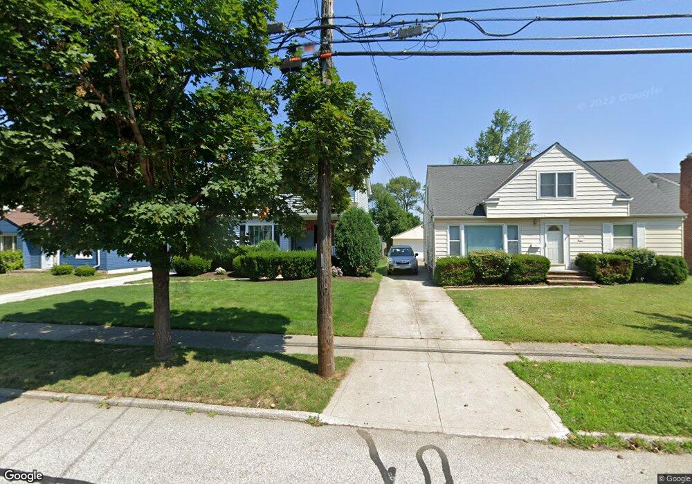
5391 Summit Rd Cleveland, OH 44124
Estimated Value: $273,082 - $307,000
4
Beds
2
Baths
2,243
Sq Ft
$130/Sq Ft
Est. Value
About This Home
This home is located at 5391 Summit Rd, Cleveland, OH 44124 and is currently estimated at $291,021, approximately $129 per square foot. 5391 Summit Rd is a home located in Cuyahoga County with nearby schools including Sunview Elementary School, Greenview Upper Elementary School, and Memorial Junior High School.
Ownership History
Date
Name
Owned For
Owner Type
Purchase Details
Closed on
Apr 20, 2010
Sold by
Weber John P and Weber Lisa A
Bought by
Grant Robert
Current Estimated Value
Home Financials for this Owner
Home Financials are based on the most recent Mortgage that was taken out on this home.
Original Mortgage
$152,093
Outstanding Balance
$101,900
Interest Rate
5.12%
Mortgage Type
FHA
Estimated Equity
$189,121
Purchase Details
Closed on
Aug 18, 2005
Sold by
Weber John P and Weber Lisa A
Bought by
Weber John P and Weber Lisa A
Purchase Details
Closed on
Nov 30, 2004
Sold by
Hirko Brian C and Hirko Pamela M
Bought by
Weber John P and Weber Lisa A
Home Financials for this Owner
Home Financials are based on the most recent Mortgage that was taken out on this home.
Original Mortgage
$60,000
Interest Rate
5.82%
Mortgage Type
Balloon
Purchase Details
Closed on
Jan 12, 1999
Sold by
Nicholl Frank R and Browske Kathy Ann
Bought by
Hirko Brian C and Hirko Pamela M
Home Financials for this Owner
Home Financials are based on the most recent Mortgage that was taken out on this home.
Original Mortgage
$120,000
Interest Rate
6.79%
Purchase Details
Closed on
May 16, 1983
Sold by
Saefkow Jack H and Saefkow Beatrice S
Bought by
Nicholl Frank R
Purchase Details
Closed on
Jan 1, 1975
Bought by
Saefkow Jack H and Saefkow Beatrice S
Create a Home Valuation Report for This Property
The Home Valuation Report is an in-depth analysis detailing your home's value as well as a comparison with similar homes in the area
Home Values in the Area
Average Home Value in this Area
Purchase History
| Date | Buyer | Sale Price | Title Company |
|---|---|---|---|
| Grant Robert | $154,900 | Maximum Title | |
| Weber John P | -- | Attorney | |
| Weber John P | $184,900 | Progressive Land Title Ag | |
| Hirko Brian C | $159,000 | Guardian Title | |
| Nicholl Frank R | $57,500 | -- | |
| Saefkow Jack H | -- | -- |
Source: Public Records
Mortgage History
| Date | Status | Borrower | Loan Amount |
|---|---|---|---|
| Open | Grant Robert | $152,093 | |
| Previous Owner | Weber John P | $60,000 | |
| Previous Owner | Hirko Brian C | $120,000 |
Source: Public Records
Tax History Compared to Growth
Tax History
| Year | Tax Paid | Tax Assessment Tax Assessment Total Assessment is a certain percentage of the fair market value that is determined by local assessors to be the total taxable value of land and additions on the property. | Land | Improvement |
|---|---|---|---|---|
| 2024 | $5,187 | $74,655 | $12,600 | $62,055 |
| 2023 | $5,569 | $63,770 | $10,080 | $53,690 |
| 2022 | $5,443 | $63,770 | $10,080 | $53,690 |
| 2021 | $5,396 | $63,770 | $10,080 | $53,690 |
| 2020 | $5,054 | $52,260 | $8,260 | $44,000 |
| 2019 | $4,555 | $149,300 | $23,600 | $125,700 |
| 2018 | $4,507 | $52,260 | $8,260 | $44,000 |
| 2017 | $4,518 | $47,850 | $7,840 | $40,010 |
| 2016 | $4,483 | $47,850 | $7,840 | $40,010 |
| 2015 | $4,539 | $47,850 | $7,840 | $40,010 |
| 2014 | $4,539 | $48,830 | $8,020 | $40,810 |
Source: Public Records
Map
Nearby Homes
- 1842 Aldersgate Dr
- 250 Eagle Point Dr
- 1922 Winchester Rd
- 5204 Haverford Dr
- 1775 Brainard Rd
- 1443 Churchill Rd
- 5159 Haverford Dr
- 1691 Harwich Rd
- 5688 Shawnee Dr
- 1857 Brainard Rd
- 5144 Oakmont Dr
- 1403 Churchill Rd
- 1856 Bremerton Rd
- 1667 Richmond Rd
- 1399 Haverston Rd
- 5560 Lansbury Ln
- 1368 Irene Rd
- 1652 Temple Ave
- 5079 Haverford Dr
- 1839 Caronia Dr