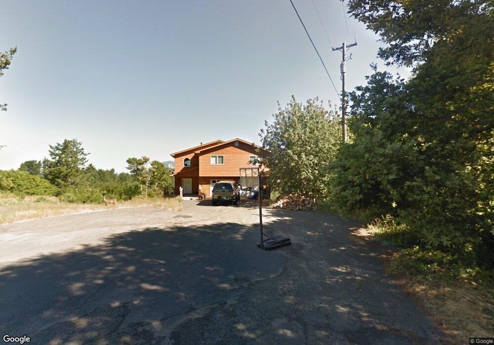
54 Cinch Ct Whitethorn, CA 95589
Estimated Value: $495,005 - $590,000
3
Beds
3
Baths
1,918
Sq Ft
$274/Sq Ft
Est. Value
About This Home
This home is located at 54 Cinch Ct, Whitethorn, CA 95589 and is currently estimated at $526,001, approximately $274 per square foot. 54 Cinch Ct is a home located in Humboldt County.
Ownership History
Date
Name
Owned For
Owner Type
Purchase Details
Closed on
Jan 26, 2016
Sold by
Traina Denise
Bought by
Griffith John
Current Estimated Value
Purchase Details
Closed on
Mar 29, 2011
Sold by
Hand Rodger D and Marchant Judith
Bought by
Griffith John H and Traina Denise M
Home Financials for this Owner
Home Financials are based on the most recent Mortgage that was taken out on this home.
Original Mortgage
$241,600
Interest Rate
4.72%
Mortgage Type
New Conventional
Purchase Details
Closed on
Jul 2, 2003
Sold by
Whitesell Brian L
Bought by
Hand Arthur D
Create a Home Valuation Report for This Property
The Home Valuation Report is an in-depth analysis detailing your home's value as well as a comparison with similar homes in the area
Home Values in the Area
Average Home Value in this Area
Purchase History
| Date | Buyer | Sale Price | Title Company |
|---|---|---|---|
| Griffith John | $161,000 | None Available | |
| Griffith John H | $302,000 | Humboldt Land Title Company | |
| Hand Arthur D | $13,000 | First American Title Ins Co |
Source: Public Records
Mortgage History
| Date | Status | Borrower | Loan Amount |
|---|---|---|---|
| Previous Owner | Griffith John H | $241,600 |
Source: Public Records
Tax History
| Year | Tax Paid | Tax Assessment Tax Assessment Total Assessment is a certain percentage of the fair market value that is determined by local assessors to be the total taxable value of land and additions on the property. | Land | Improvement |
|---|---|---|---|---|
| 2025 | $4,377 | $385,814 | $77,698 | $308,116 |
| 2024 | $4,377 | $378,250 | $76,175 | $302,075 |
| 2023 | $4,394 | $370,834 | $74,682 | $296,152 |
| 2022 | $4,329 | $363,564 | $73,218 | $290,346 |
| 2021 | $4,172 | $356,436 | $71,783 | $284,653 |
| 2020 | $4,197 | $352,782 | $71,047 | $281,735 |
| 2019 | $4,096 | $345,865 | $69,654 | $276,211 |
| 2018 | $4,029 | $339,085 | $68,289 | $270,796 |
| 2017 | $3,857 | $332,437 | $66,950 | $265,487 |
| 2016 | $3,767 | $326,839 | $56,275 | $270,564 |
| 2015 | -- | $321,930 | $55,430 | $266,500 |
| 2014 | $3,601 | $315,625 | $54,345 | $261,280 |
Source: Public Records
Map
Nearby Homes
- 582 Upper Pacific Dr
- 592 Upper Pacific Dr
- 560 Upper Pacific Dr
- 34 Cinch Ct
- 40 Saddle Ct
- 612 Upper Pacific Dr
- 484 & 494 Upper Pacific Dr
- 25 Cinch Ct
- 31 Lariat Ct
- 20 Cinch Ct
- 15 Cinch Ct
- 47 Saddle Ct
- 50 Lariat Ct
- 65 Lariat Ct
- 5 Cinch Ct
- 62 Lariat Ct
- 47 Lariat Ct
- 615 Upper Pacific Dr
- 40 Sadie Ct
- 24 Lariat Ct