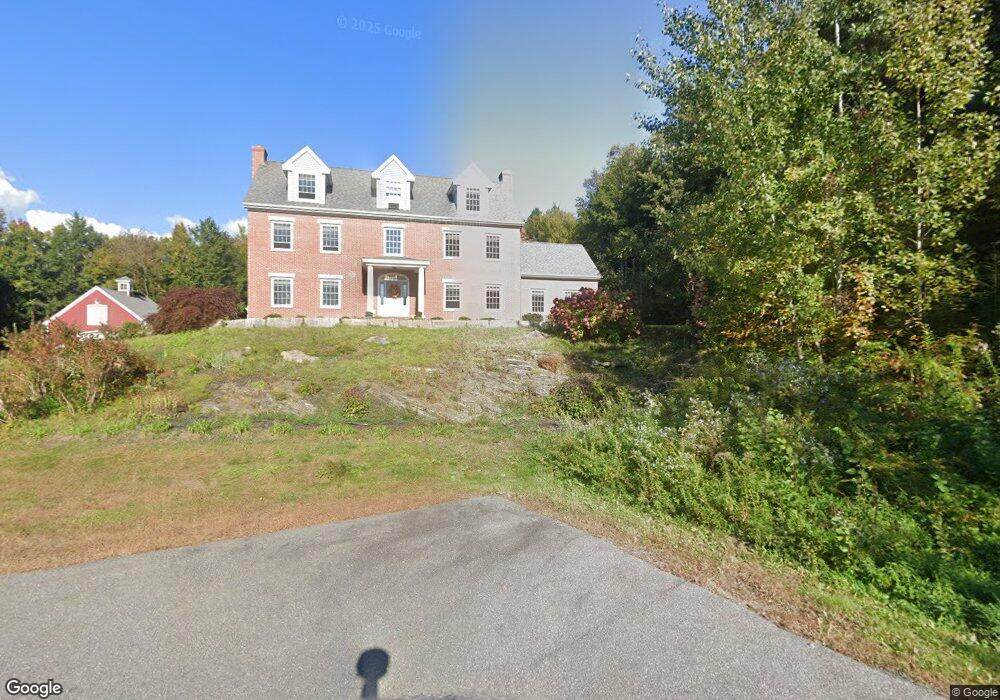
54 Fieldstone Ln Falmouth, ME 04105
Estimated Value: $1,835,610 - $2,204,000
3
Beds
2
Baths
4,675
Sq Ft
$420/Sq Ft
Est. Value
About This Home
This home is located at 54 Fieldstone Ln, Falmouth, ME 04105 and is currently estimated at $1,963,403, approximately $419 per square foot. 54 Fieldstone Ln is a home located in Cumberland County with nearby schools including Falmouth Middle School and Falmouth High School.
Ownership History
Date
Name
Owned For
Owner Type
Purchase Details
Closed on
Dec 5, 2005
Sold by
White Therese K and Mullen Paul R
Bought by
White Therese K and Mullen Paul R
Current Estimated Value
Create a Home Valuation Report for This Property
The Home Valuation Report is an in-depth analysis detailing your home's value as well as a comparison with similar homes in the area
Home Values in the Area
Average Home Value in this Area
Purchase History
| Date | Buyer | Sale Price | Title Company |
|---|---|---|---|
| White Therese K | -- | -- |
Source: Public Records
Tax History Compared to Growth
Tax History
| Year | Tax Paid | Tax Assessment Tax Assessment Total Assessment is a certain percentage of the fair market value that is determined by local assessors to be the total taxable value of land and additions on the property. | Land | Improvement |
|---|---|---|---|---|
| 2024 | $18,648 | $1,393,700 | $454,800 | $938,900 |
| 2023 | $17,563 | $1,389,500 | $454,800 | $934,700 |
| 2022 | $16,563 | $1,389,500 | $454,800 | $934,700 |
| 2021 | $15,638 | $897,200 | $256,100 | $641,100 |
| 2020 | $15,297 | $897,200 | $256,100 | $641,100 |
| 2019 | $15,136 | $897,200 | $256,100 | $641,100 |
| 2018 | $14,777 | $897,200 | $256,100 | $641,100 |
| 2017 | $14,014 | $897,200 | $256,100 | $641,100 |
| 2016 | $13,539 | $897,200 | $256,100 | $641,100 |
| 2015 | $13,126 | $897,200 | $256,100 | $641,100 |
| 2014 | $12,510 | $897,200 | $256,100 | $641,100 |
| 2012 | -- | $897,200 | $256,100 | $641,100 |
Source: Public Records
Map
Nearby Homes
- Lot 3 Dunham Ln
- Lot 2 Dunham Ln
- TBD Harris Lot 2 Rd
- 99 Chets Way
- 133 Longwoods Rd
- 3 Winnwood Farm Way
- 11 Coastal Pines Lot 5
- TBD Coastal Pines Lot 2
- TBD Coastal Pines Lot 8
- Lot 8 Coastal Pines
- 90 Harris Lot 1 Rd
- 199 Winn Rd
- 5 Harmony Way
- 4 Periwinkle Way
- 3 Red Pine Way
- 1 Red Pine Way
- 67 Field Rd
- 54 Longwoods Rd
- 10 Casco Bay Dr
- 193 Main St
- 7 Little Brook Dr
- 11 Little Brook Dr
- 13 Little Brook Dr
- 32 Longwoods Rd
- 44 Fieldstone Ln
- 15 Longwoods Rd
- 5 Longwoods Rd
- 210 Longwoods Rd
- 17 Longwoods Rd
- 17 Longwoods Rd
- 41 Fieldstone Ln
- 18 Little Brook Dr
- 19 Longwoods Rd
- 1 Longwoods Rd
- 331 Harris Rd Unit 1
- 3 Longwoods Rd
- 23 Longwoods Rd
- 200 Longwoods Rd
- 325 Harris Rd
- 7 White Pine Way