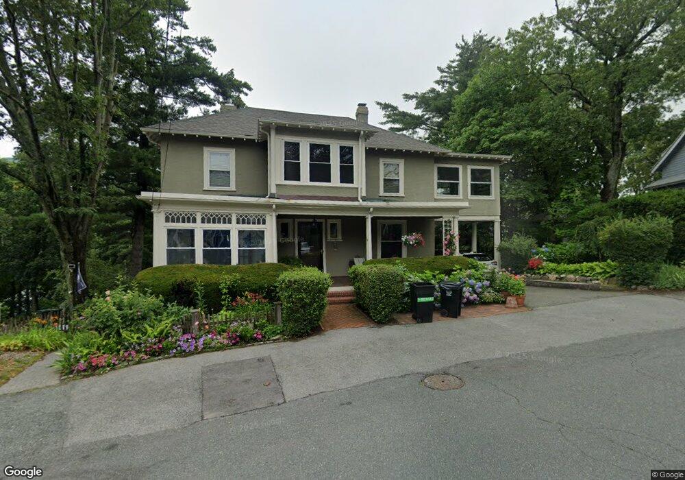
54 Mountwood Rd Swampscott, MA 01907
Estimated Value: $943,282 - $1,415,000
4
Beds
3
Baths
1,860
Sq Ft
$618/Sq Ft
Est. Value
About This Home
This home is located at 54 Mountwood Rd, Swampscott, MA 01907 and is currently estimated at $1,149,321, approximately $617 per square foot. 54 Mountwood Rd is a home located in Essex County with nearby schools including Swampscott Middle School and Swampscott High School.
Ownership History
Date
Name
Owned For
Owner Type
Purchase Details
Closed on
Aug 12, 2021
Sold by
Simons Barbara K and Simons Joel H
Bought by
J H & Barbara K Simons Lt
Current Estimated Value
Purchase Details
Closed on
Feb 19, 1987
Sold by
Rosenberg Kenneth B
Bought by
Simons Joel H
Home Financials for this Owner
Home Financials are based on the most recent Mortgage that was taken out on this home.
Original Mortgage
$153,000
Interest Rate
9.24%
Mortgage Type
Purchase Money Mortgage
Create a Home Valuation Report for This Property
The Home Valuation Report is an in-depth analysis detailing your home's value as well as a comparison with similar homes in the area
Home Values in the Area
Average Home Value in this Area
Purchase History
| Date | Buyer | Sale Price | Title Company |
|---|---|---|---|
| J H & Barbara K Simons Lt | -- | None Available | |
| J H & Barbara K Simons Lt | -- | None Available | |
| J H & Barbara K Simons Lt | -- | None Available | |
| Simons Joel H | $282,000 | -- |
Source: Public Records
Mortgage History
| Date | Status | Borrower | Loan Amount |
|---|---|---|---|
| Previous Owner | Simons Joel H | $165,000 | |
| Previous Owner | Simons Joel H | $180,000 | |
| Previous Owner | Simons Joel H | $180,000 | |
| Previous Owner | Simons Joel H | $153,000 |
Source: Public Records
Tax History Compared to Growth
Tax History
| Year | Tax Paid | Tax Assessment Tax Assessment Total Assessment is a certain percentage of the fair market value that is determined by local assessors to be the total taxable value of land and additions on the property. | Land | Improvement |
|---|---|---|---|---|
| 2025 | $10,474 | $913,200 | $429,900 | $483,300 |
| 2024 | $10,035 | $873,400 | $408,900 | $464,500 |
| 2023 | $9,353 | $796,700 | $367,000 | $429,700 |
| 2022 | $8,923 | $695,500 | $314,500 | $381,000 |
| 2021 | $8,846 | $641,000 | $293,600 | $347,400 |
| 2020 | $8,640 | $604,200 | $262,100 | $342,100 |
| 2019 | $8,786 | $578,000 | $235,900 | $342,100 |
| 2018 | $8,706 | $544,100 | $214,900 | $329,200 |
| 2017 | $8,896 | $509,800 | $201,300 | $308,500 |
| 2016 | $8,835 | $509,800 | $201,300 | $308,500 |
| 2015 | $8,743 | $509,800 | $201,300 | $308,500 |
| 2014 | $7,974 | $426,400 | $167,800 | $258,600 |
Source: Public Records
Map
Nearby Homes
- 309 Paradise Rd
- 306 Paradise Rd
- 5 Summit View Dr
- 71 Walnut Rd
- 51 Barnstable St
- 10-12 Fairview Ave
- 2 Gracie Ln Unit 4
- 445 Essex St Unit 304
- 71 Greenwood Ave Unit 207
- 76 Stetson Ave
- 8 Ryan Place
- 75 Bay View Dr
- 98 Paradise Rd
- 140 Elmwood Rd
- 13 Cedar Hill Terrace Unit 2
- 106 Norfolk Ave
- 8 Ocean View Rd
- 21 Bay View Dr
- 1004 Paradise Rd Unit PHJ
- 80 Norfolk Ave Unit 1
- 50 Mountwood Rd
- 60 Mountwood Rd
- 63 Mountwood Rd Unit na
- 63 Mountwood Rd Unit 63
- 51 Mountwood Rd
- 48 Mountwood Rd
- 59 Mountwood Rd
- 181 Walker Rd
- 183 Walker Rd
- 177 Walker Rd
- 47 Mountwood Rd
- 68 Mountwood Rd
- 171 Walker Rd
- 67 Mountwood Rd
- 65 Mountwood Rd
- 65 Mountwood Rd
- 79 Mountwood Rd
- 167 Walker Rd Unit 169
- 167-169 Walker Rd
- 169 Walker Rd Unit 2