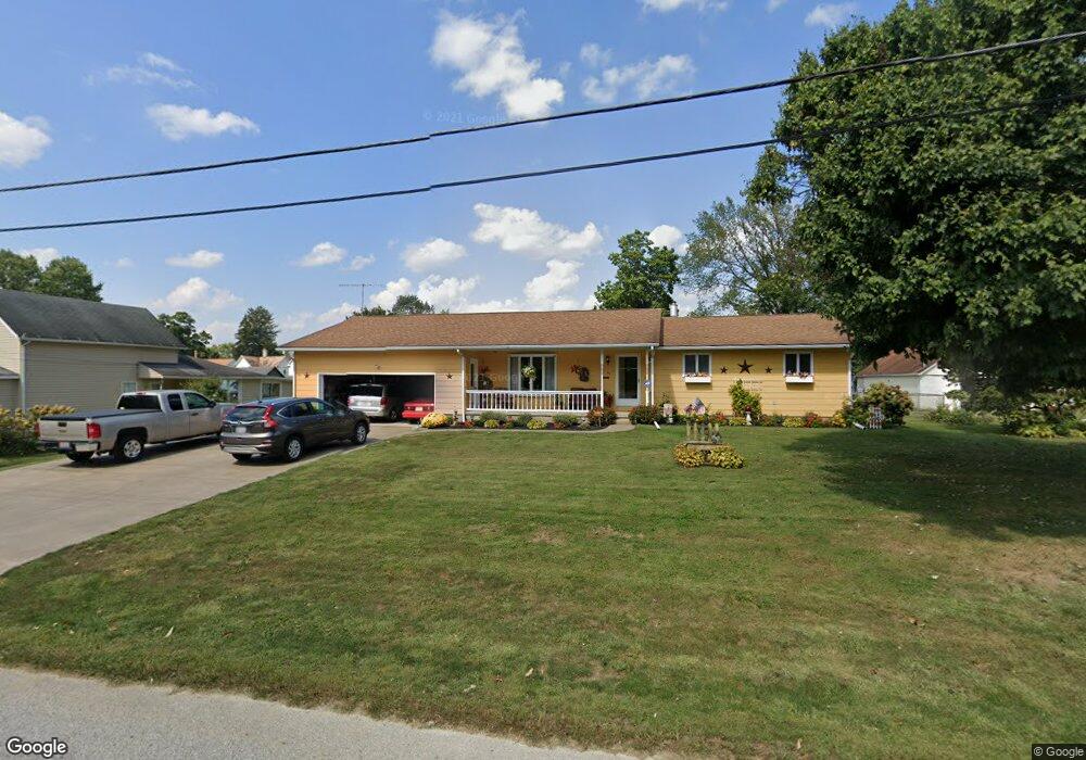
54 Orchard St Newark, OH 43055
Estimated Value: $236,000 - $273,793
4
Beds
2
Baths
1,584
Sq Ft
$160/Sq Ft
Est. Value
About This Home
This home is located at 54 Orchard St, Newark, OH 43055 and is currently estimated at $253,448, approximately $160 per square foot. 54 Orchard St is a home located in Licking County with nearby schools including Ben Franklin Elementary School, Wilson Middle School, and Newark High School.
Ownership History
Date
Name
Owned For
Owner Type
Purchase Details
Closed on
Oct 3, 2022
Sold by
Bowers Lowell W
Bought by
Bowers Lowell W and Bowers Nancy L
Current Estimated Value
Purchase Details
Closed on
Jul 21, 1997
Sold by
Diener Robert C
Bought by
Litten Jay E
Home Financials for this Owner
Home Financials are based on the most recent Mortgage that was taken out on this home.
Original Mortgage
$50,000
Interest Rate
7.94%
Mortgage Type
New Conventional
Create a Home Valuation Report for This Property
The Home Valuation Report is an in-depth analysis detailing your home's value as well as a comparison with similar homes in the area
Home Values in the Area
Average Home Value in this Area
Purchase History
| Date | Buyer | Sale Price | Title Company |
|---|---|---|---|
| Bowers Lowell W | -- | None Listed On Document | |
| Litten Jay E | $50,000 | -- |
Source: Public Records
Mortgage History
| Date | Status | Borrower | Loan Amount |
|---|---|---|---|
| Previous Owner | Litten Jay E | $50,000 |
Source: Public Records
Tax History Compared to Growth
Tax History
| Year | Tax Paid | Tax Assessment Tax Assessment Total Assessment is a certain percentage of the fair market value that is determined by local assessors to be the total taxable value of land and additions on the property. | Land | Improvement |
|---|---|---|---|---|
| 2024 | $2,265 | $73,190 | $23,310 | $49,880 |
| 2023 | $2,285 | $80,360 | $23,310 | $57,050 |
| 2022 | $2,153 | $62,450 | $11,660 | $50,790 |
| 2021 | $2,258 | $62,450 | $11,660 | $50,790 |
| 2020 | $2,309 | $62,450 | $11,660 | $50,790 |
| 2019 | $2,020 | $53,980 | $11,660 | $42,320 |
| 2018 | $2,021 | $0 | $0 | $0 |
| 2017 | $3,126 | $0 | $0 | $0 |
| 2016 | $2,403 | $0 | $0 | $0 |
| 2015 | $740 | $0 | $0 | $0 |
| 2014 | $726 | $0 | $0 | $0 |
| 2013 | $702 | $0 | $0 | $0 |
Source: Public Records
Map
Nearby Homes
- 210-212 Isabelle Rd
- 206-208 Isabelle Rd
- 158 Isabelle Rd
- 150/152 Isabelle Rd
- 940 Hopewell Heights Dr
- 507 Beacon Rd
- 727 Francis Dr
- 1335 Grandview Ave
- 730 Francis Dr
- 1310 Kacey St
- 1309 Kacey Ct
- 720 Francis Dr
- 728 Francis Dr
- Cumberland Plan at Royal Acres - Maple Street Collection
- Cumberland Plan at Linnview Crossing - Maple Street Collection
- Denali Plan at Linnview Crossing - Maple Street Collection
- Jensen Plan at Linnview Crossing - Maple Street Collection
- Fairfax Plan at Linnview Crossing - Maple Street Collection
- Yosemite Plan at Linnview Crossing - Maple Street Collection
- Wesley Plan at Linnview Crossing - Maple Street Collection