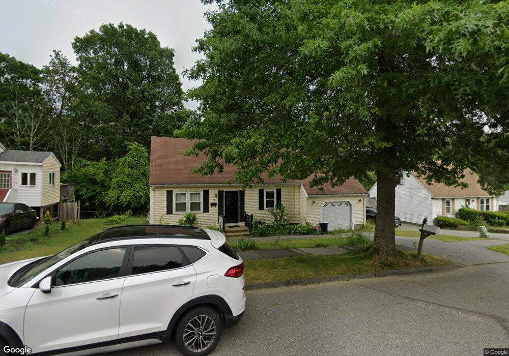
54 Parsons Hill Dr Worcester, MA 01603
Webster Square NeighborhoodEstimated Value: $411,000 - $509,000
3
Beds
2
Baths
1,880
Sq Ft
$244/Sq Ft
Est. Value
About This Home
This home is located at 54 Parsons Hill Dr, Worcester, MA 01603 and is currently estimated at $459,409, approximately $244 per square foot. 54 Parsons Hill Dr is a home located in Worcester County with nearby schools including Gates Lane, Jacob Hiatt Magnet School, and Chandler Magnet.
Ownership History
Date
Name
Owned For
Owner Type
Purchase Details
Closed on
Apr 20, 1995
Sold by
Citicorp Mtg Inc
Bought by
Alicpour Joan
Current Estimated Value
Purchase Details
Closed on
Feb 2, 1995
Sold by
Malakham Mak
Bought by
Citicorp Mtg Inc
Purchase Details
Closed on
May 4, 1989
Sold by
Przygoda David
Bought by
Malakhan Mak
Create a Home Valuation Report for This Property
The Home Valuation Report is an in-depth analysis detailing your home's value as well as a comparison with similar homes in the area
Home Values in the Area
Average Home Value in this Area
Purchase History
| Date | Buyer | Sale Price | Title Company |
|---|---|---|---|
| Alicpour Joan | $95,000 | -- | |
| Citicorp Mtg Inc | $76,300 | -- | |
| Malakhan Mak | $130,000 | -- |
Source: Public Records
Mortgage History
| Date | Status | Borrower | Loan Amount |
|---|---|---|---|
| Open | Malakhan Mak | $169,150 | |
| Closed | Malakhan Mak | $18,049 |
Source: Public Records
Tax History
| Year | Tax Paid | Tax Assessment Tax Assessment Total Assessment is a certain percentage of the fair market value that is determined by local assessors to be the total taxable value of land and additions on the property. | Land | Improvement |
|---|---|---|---|---|
| 2025 | $5,636 | $427,300 | $98,600 | $328,700 |
| 2024 | $5,481 | $398,600 | $98,600 | $300,000 |
| 2023 | $5,393 | $376,100 | $85,700 | $290,400 |
| 2022 | $4,987 | $327,900 | $68,600 | $259,300 |
| 2021 | $5,003 | $307,300 | $54,900 | $252,400 |
| 2020 | $4,825 | $283,800 | $54,500 | $229,300 |
| 2019 | $4,558 | $253,200 | $47,600 | $205,600 |
| 2018 | $4,546 | $240,400 | $47,600 | $192,800 |
| 2017 | $4,311 | $224,300 | $47,600 | $176,700 |
| 2016 | $4,347 | $210,900 | $34,100 | $176,800 |
| 2015 | $4,233 | $210,900 | $34,100 | $176,800 |
| 2014 | $4,123 | $211,000 | $34,100 | $176,900 |
Source: Public Records
Map
Nearby Homes
- 55 Parsons Hill Dr
- 18 Sherer Trail
- 5 Utica Dr
- 168 Apricot St
- 43 Grandview Ave
- 19 Healy Rd
- 1560 Main St
- 1511 Main St Unit CPH9
- 42 3rd St
- 92-94 Sargent St
- 10 Hulbert Rd Unit 10
- 23 Lakewood St
- 29 Outlook Dr
- 5 Swan Ave Unit B
- 28 Lakewood St
- 60 Circuit Ave S
- 15 Circuit Ave E
- 14 Circuit Ave E
- 152 Beaverbrook Pkwy
- 114 Lovell St
- 56 Parsons Hill Dr
- 52 Parsons Hill Dr
- 58 Parsons Hill Dr
- 50 Parsons Hill Dr
- 53 Parsons Hill Dr
- 57 Parsons Hill Dr
- 60 Parsons Hill Dr
- 51 Parsons Hill Dr
- 59 Parsons Hill Dr
- 49 Parsons Hill Dr
- 62 Parsons Hill Dr
- 48 Parsons Hill Dr
- 33B Timrod Dr Unit B
- 33B Timrod Dr
- 35 Timrod Dr
- 33A Timrod Dr
- 61 Parsons Hill Dr
- 31B Timrod Dr
- 33 Timrod Dr Unit A
- 33 Timrod Dr
Your Personal Tour Guide
Ask me questions while you tour the home.