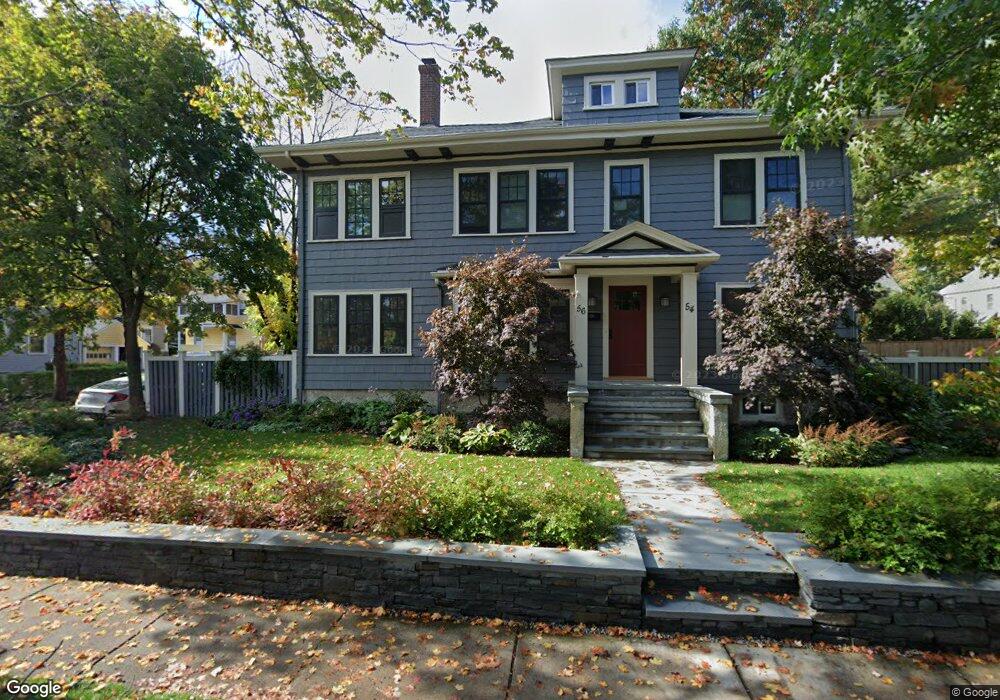
54 Pine St Unit 1 Belmont, MA 02478
Cushing Square NeighborhoodEstimated Value: $1,474,000 - $2,073,150
4
Beds
2
Baths
2,500
Sq Ft
$685/Sq Ft
Est. Value
About This Home
This home is located at 54 Pine St Unit 1, Belmont, MA 02478 and is currently estimated at $1,713,538, approximately $685 per square foot. 54 Pine St Unit 1 is a home located in Middlesex County with nearby schools including Roger Wellington Elementary School, Winthrop L Chenery Middle School, and Belmont High School.
Ownership History
Date
Name
Owned For
Owner Type
Purchase Details
Closed on
Sep 2, 1997
Sold by
Abrams Kirkland C
Bought by
Esptein David M and Wu Leah Z
Current Estimated Value
Home Financials for this Owner
Home Financials are based on the most recent Mortgage that was taken out on this home.
Original Mortgage
$338,200
Interest Rate
7.41%
Mortgage Type
Purchase Money Mortgage
Create a Home Valuation Report for This Property
The Home Valuation Report is an in-depth analysis detailing your home's value as well as a comparison with similar homes in the area
Home Values in the Area
Average Home Value in this Area
Purchase History
| Date | Buyer | Sale Price | Title Company |
|---|---|---|---|
| Esptein David M | $356,000 | -- |
Source: Public Records
Mortgage History
| Date | Status | Borrower | Loan Amount |
|---|---|---|---|
| Open | Esptein David M | $340,000 | |
| Closed | Esptein David M | $338,200 | |
| Previous Owner | Esptein David M | $186,000 |
Source: Public Records
Tax History
| Year | Tax Paid | Tax Assessment Tax Assessment Total Assessment is a certain percentage of the fair market value that is determined by local assessors to be the total taxable value of land and additions on the property. | Land | Improvement |
|---|---|---|---|---|
| 2025 | $24,318 | $2,135,000 | $785,000 | $1,350,000 |
| 2024 | $20,729 | $1,963,000 | $880,000 | $1,083,000 |
| 2023 | $19,198 | $1,708,000 | $830,000 | $878,000 |
| 2022 | $15,360 | $1,618,000 | $802,000 | $816,000 |
| 2021 | $15,360 | $1,331,000 | $794,000 | $537,000 |
| 2020 | $15,213 | $1,383,000 | $819,000 | $564,000 |
| 2019 | $13,829 | $1,185,000 | $649,000 | $536,000 |
| 2018 | $13,608 | $1,120,000 | $590,000 | $530,000 |
| 2017 | $13,528 | $1,066,000 | $541,000 | $525,000 |
| 2016 | $13,351 | $1,063,000 | $541,000 | $522,000 |
| 2015 | $11,197 | $868,000 | $422,000 | $446,000 |
Source: Public Records
Map
Nearby Homes
- 519 Belmont St
- 519 Belmont St Unit 2
- 125 Trapelo Rd Unit 21
- 29 Commonwealth Rd Unit 1
- 12 Carver Rd
- 50 Poplar St
- 7-9 Clyde Rd
- 182 Maplewood St Unit 2
- 147 Langdon Ave Unit 1
- 60 Washington St
- 75 Foster Rd Unit 1
- 73 Foster Rd Unit 2
- 7 Mason Rd
- 11 Hillcrest Rd
- 210 Belmont St Unit 13
- 210 Belmont St Unit 2
- 198 Belmont St Unit 1
- 324 Mount Auburn St Unit 2
- 15 Wiley Rd Unit 15
- 30 Unity Ave Unit 30
Your Personal Tour Guide
Ask me questions while you tour the home.