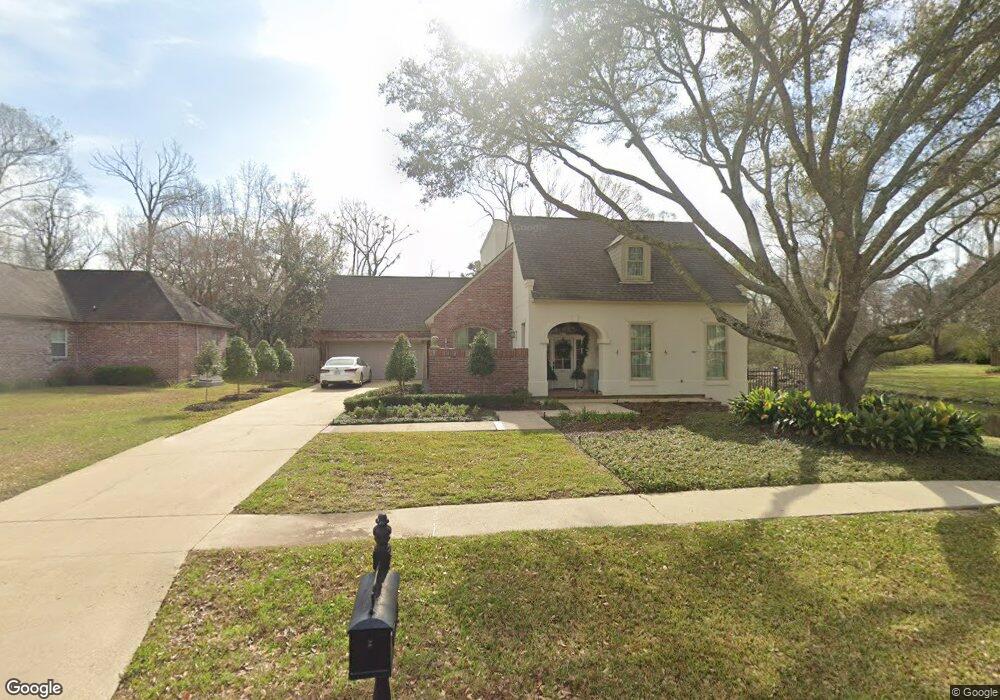
540 Highland Trace Dr Baton Rouge, LA 70810
Oak Hills Place NeighborhoodEstimated Value: $591,000 - $656,000
4
Beds
4
Baths
3,218
Sq Ft
$195/Sq Ft
Est. Value
About This Home
This home is located at 540 Highland Trace Dr, Baton Rouge, LA 70810 and is currently estimated at $627,889, approximately $195 per square foot. 540 Highland Trace Dr is a home located in East Baton Rouge Parish with nearby schools including Woodlawn Middle School, Woodlawn High School, and South Baton Rouge Charter Academy.
Ownership History
Date
Name
Owned For
Owner Type
Purchase Details
Closed on
Dec 29, 2005
Sold by
Reynolds Gina N
Bought by
Reynolds Aidan C
Current Estimated Value
Home Financials for this Owner
Home Financials are based on the most recent Mortgage that was taken out on this home.
Original Mortgage
$340,000
Outstanding Balance
$190,653
Interest Rate
6.23%
Mortgage Type
New Conventional
Estimated Equity
$437,236
Purchase Details
Closed on
Dec 5, 2000
Sold by
Robinson Maxwell Gerald and Robinson Sandi Fornea
Bought by
Robinson Maxwell Gerald
Create a Home Valuation Report for This Property
The Home Valuation Report is an in-depth analysis detailing your home's value as well as a comparison with similar homes in the area
Home Values in the Area
Average Home Value in this Area
Purchase History
| Date | Buyer | Sale Price | Title Company |
|---|---|---|---|
| Reynolds Aidan C | $57,178 | -- | |
| Robinson Maxwell Gerald | -- | -- |
Source: Public Records
Mortgage History
| Date | Status | Borrower | Loan Amount |
|---|---|---|---|
| Open | Reynolds Aidan C | $340,000 |
Source: Public Records
Tax History Compared to Growth
Tax History
| Year | Tax Paid | Tax Assessment Tax Assessment Total Assessment is a certain percentage of the fair market value that is determined by local assessors to be the total taxable value of land and additions on the property. | Land | Improvement |
|---|---|---|---|---|
| 2024 | $5,490 | $55,130 | $6,000 | $49,130 |
| 2023 | $5,490 | $47,680 | $6,000 | $41,680 |
| 2022 | $5,381 | $47,680 | $6,000 | $41,680 |
| 2021 | $5,276 | $47,680 | $6,000 | $41,680 |
| 2020 | $5,240 | $47,680 | $6,000 | $41,680 |
| 2019 | $5,059 | $44,250 | $6,000 | $38,250 |
| 2018 | $4,993 | $44,250 | $6,000 | $38,250 |
| 2017 | $4,993 | $44,250 | $6,000 | $38,250 |
| 2016 | $4,043 | $44,250 | $6,000 | $38,250 |
| 2015 | $3,438 | $38,750 | $6,000 | $32,750 |
| 2014 | $3,363 | $38,750 | $6,000 | $32,750 |
| 2013 | -- | $38,750 | $6,000 | $32,750 |
Source: Public Records
Map
Nearby Homes
- 13524 Kimble Ave
- Belmont II Plan at Atwater Reserve
- Clayton Plan at Atwater Reserve
- Vacherie Plan at Atwater Reserve
- Duplessis Plan at Atwater Reserve
- Stanton Plan at Atwater Reserve
- Magnolia Plan at Atwater Reserve
- Iris Plan at Atwater Reserve
- Burnside Plan at Atwater Reserve
- Brittany Plan at Atwater Reserve
- Gramercy Plan at Atwater Reserve
- 1227 Westchester Dr
- 902 Woodhue Dr
- 10334 Highland Rd
- 10344 Highland Rd
- 13415 Highland Rd
- 0 Unknown Unit 2025017336
- 10242 Winterhue Dr
- 12800-12900 UND Highland Rd
- 10327 Rustic Oak Dr
- 550 Highland Trace Dr
- 530 Highland Trace Dr
- 13544 Kimble Ave
- 0 Kimble Ave
- 13535 Mosher Ct
- 13625 Kimble Ave
- 520 Highland Trace Dr
- 13615 Kimble Ave
- 13534 Kimble Ave
- 13525 Mosher Ct
- 13543 Kimble Ave
- 438 Highland Trace Dr
- 13524 Kimble Ave
- 13524 Kimble Ave
- 13533 Kimble Ave
- 437 Highland Trace Dr
- 13536 Mosher Ct
- 13536 Mosher Ct
- 13505 Mosher Ct
- 13417 N Amiss Rd