Estimated Value: $245,944 - $278,000
3
Beds
2
Baths
1,120
Sq Ft
$236/Sq Ft
Est. Value
About This Home
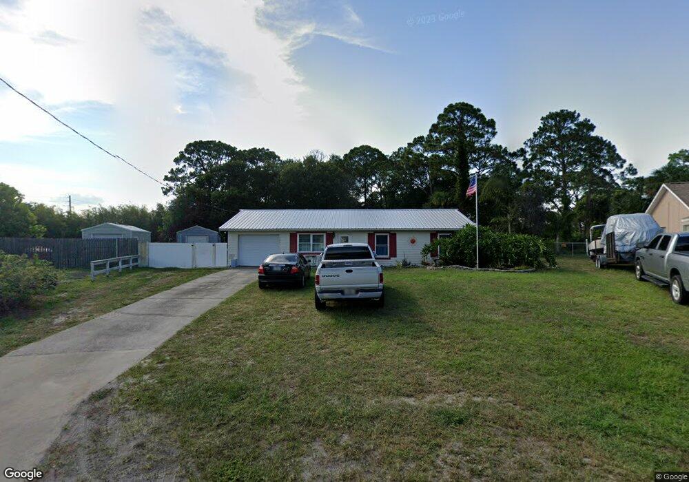
This home is located at 5400 Fruitport St, Cocoa, FL 32927 and is currently estimated at $263,986, approximately $235 per square foot. 5400 Fruitport St is a home located in Brevard County with nearby schools including Enterprise Elementary School, Space Coast Junior/Senior High School, and East Atlantic Prep of Brevard County.
Ownership History
Date
Name
Owned For
Owner Type
Purchase Details
Closed on
Oct 30, 2006
Sold by
Stanton Richard D and Stanton Rita A
Bought by
Ladd Robert A and Ladd Katrina L
Current Estimated Value
Home Financials for this Owner
Home Financials are based on the most recent Mortgage that was taken out on this home.
Original Mortgage
$154,664
Interest Rate
6.25%
Purchase Details
Closed on
Apr 27, 2000
Sold by
Stanton Richard D and Stanton Rita A
Bought by
Stanton Richard D and Stanton Rita A
Purchase Details
Closed on
Apr 9, 1999
Sold by
Golumbeck John C and Golumbeck Barbara A
Bought by
Stanton Richard D
Home Financials for this Owner
Home Financials are based on the most recent Mortgage that was taken out on this home.
Original Mortgage
$51,973
Interest Rate
7.08%
Mortgage Type
Purchase Money Mortgage
Create a Home Valuation Report for This Property
The Home Valuation Report is an in-depth analysis detailing your home's value as well as a comparison with similar homes in the area
Home Values in the Area
Average Home Value in this Area
Purchase History
| Date | Buyer | Sale Price | Title Company |
|---|---|---|---|
| Ladd Robert A | $149,900 | Space Coast Title Company | |
| Stanton Richard D | -- | -- | |
| Stanton Richard D | $52,000 | -- |
Source: Public Records
Mortgage History
| Date | Status | Borrower | Loan Amount |
|---|---|---|---|
| Closed | Ladd Robert A | $154,664 | |
| Previous Owner | Stanton Richard D | $51,973 |
Source: Public Records
Tax History Compared to Growth
Tax History
| Year | Tax Paid | Tax Assessment Tax Assessment Total Assessment is a certain percentage of the fair market value that is determined by local assessors to be the total taxable value of land and additions on the property. | Land | Improvement |
|---|---|---|---|---|
| 2025 | $956 | $63,570 | -- | -- |
| 2024 | $938 | $61,780 | -- | -- |
| 2023 | $938 | $59,990 | $0 | $0 |
| 2022 | $893 | $58,250 | $0 | $0 |
| 2021 | $893 | $56,560 | $0 | $0 |
| 2020 | $847 | $55,780 | $0 | $0 |
| 2019 | $795 | $54,530 | $0 | $0 |
| 2018 | $795 | $53,520 | $0 | $0 |
| 2017 | $794 | $52,420 | $0 | $0 |
| 2016 | $799 | $51,350 | $18,000 | $33,350 |
| 2015 | $803 | $51,000 | $15,000 | $36,000 |
| 2014 | $807 | $50,600 | $11,000 | $39,600 |
Source: Public Records
Map
Nearby Homes
- 6615 Dock Ave
- 00 Unknown
- 6581 Bancroft Ave
- 5575 Curtis Blvd
- 4650 N Highway 1 Hwy
- 6760 Cairo Rd
- 5275 Holden Rd
- 5715 Fairbridge St
- 5220 Holden Rd
- 5460 Holden Rd
- 5215 Holden Rd
- 5446 Jamaica Rd
- 6375 Cable Ave
- 0000 Grissom Pkwy
- 6620 Grissom Pkwy
- 5049 Jamaica Rd
- 5720 Flint Rd
- 6309 Alleghany Ave
- 7065 Hundred Acre Dr
- 4975 Fay Blvd
- 5400 Flint Rd
- 5408 Flint Rd
- 5385 Fruitport St
- 6455 Gillette Ave
- 5416 Flint Rd
- 5370 Fruitport St
- 5401 Flint Rd
- 5360 Fruitport St
- 5409 Flint Rd
- 5380 Fruitport St
- 5350 Fruitport St
- 5417 Flint Rd
- 6435 Gillette Ave
- 5340 Fruitport St
- 6490 Fairchild Ave
- 6460 Gillette Ave
- 6450 Gillette Ave
- 5425 Flint Rd
- 5432 Flint Rd
- 6466 Fairchild Ave