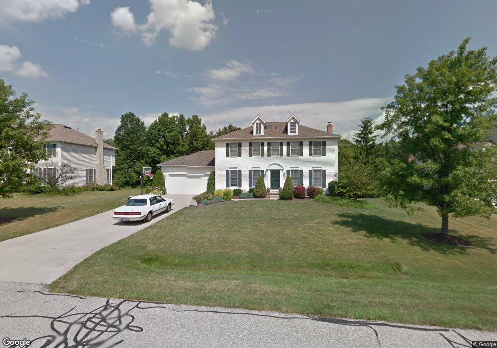
5401 Brooklands Dr Hudson, OH 44236
Estimated Value: $475,616 - $501,000
4
Beds
3
Baths
2,352
Sq Ft
$209/Sq Ft
Est. Value
About This Home
This home is located at 5401 Brooklands Dr, Hudson, OH 44236 and is currently estimated at $491,904, approximately $209 per square foot. 5401 Brooklands Dr is a home located in Summit County with nearby schools including Ellsworth Hill Elementary School, East Woods Intermediate School, and Hudson Middle School.
Ownership History
Date
Name
Owned For
Owner Type
Purchase Details
Closed on
Jun 9, 1997
Sold by
Walsh J Neal
Bought by
Hodnick Richard J and Hodnick Sandra R
Current Estimated Value
Home Financials for this Owner
Home Financials are based on the most recent Mortgage that was taken out on this home.
Original Mortgage
$162,000
Outstanding Balance
$23,562
Interest Rate
8.17%
Mortgage Type
New Conventional
Estimated Equity
$468,342
Purchase Details
Closed on
May 16, 1995
Sold by
Encore Homes Inc
Bought by
Neal J and Walsh Lisa J
Home Financials for this Owner
Home Financials are based on the most recent Mortgage that was taken out on this home.
Original Mortgage
$172,000
Interest Rate
7.13%
Mortgage Type
New Conventional
Purchase Details
Closed on
Aug 1, 1994
Sold by
Gatewood Assoc
Bought by
Encore Homes Inc
Create a Home Valuation Report for This Property
The Home Valuation Report is an in-depth analysis detailing your home's value as well as a comparison with similar homes in the area
Home Values in the Area
Average Home Value in this Area
Purchase History
| Date | Buyer | Sale Price | Title Company |
|---|---|---|---|
| Hodnick Richard J | $206,000 | -- | |
| Neal J | $202,000 | -- | |
| Encore Homes Inc | $160,000 | -- |
Source: Public Records
Mortgage History
| Date | Status | Borrower | Loan Amount |
|---|---|---|---|
| Open | Hodnick Richard J | $162,000 | |
| Previous Owner | Neal J | $172,000 |
Source: Public Records
Tax History
| Year | Tax Paid | Tax Assessment Tax Assessment Total Assessment is a certain percentage of the fair market value that is determined by local assessors to be the total taxable value of land and additions on the property. | Land | Improvement |
|---|---|---|---|---|
| 2025 | $7,581 | $145,615 | $34,199 | $111,416 |
| 2024 | $7,581 | $145,615 | $34,199 | $111,416 |
| 2023 | $7,581 | $145,615 | $34,199 | $111,416 |
| 2022 | $5,808 | $99,177 | $23,265 | $75,912 |
| 2021 | $5,817 | $99,177 | $23,265 | $75,912 |
| 2020 | $5,717 | $99,180 | $23,270 | $75,910 |
| 2019 | $5,834 | $93,710 | $18,820 | $74,890 |
| 2018 | $5,816 | $93,710 | $18,820 | $74,890 |
| 2017 | $5,367 | $93,710 | $18,820 | $74,890 |
| 2016 | $5,404 | $83,820 | $18,820 | $65,000 |
| 2015 | $5,367 | $83,820 | $18,820 | $65,000 |
| 2014 | $5,382 | $83,820 | $18,820 | $65,000 |
| 2013 | $5,709 | $86,900 | $18,820 | $68,080 |
Source: Public Records
Map
Nearby Homes
- 1995 Weston Dr
- 5361 Diana Lynn Dr
- V/L Norton Rd
- 5091 Ridge Meadow Dr
- 2221 Crockett Cir
- 1620 Sapphire Dr
- 2188 Duxbury
- 5123 Sodalite Dr
- 2279 Becket Cir
- 4916 Friar Rd Unit B
- 4704 Red Willow Rd
- 4909 Fishcreek Rd
- 1525 Spruce Hill Dr
- 4623 Cox Dr
- 4424 Timberdale Dr Unit 4428
- 2353 W Hale Dr
- 5974 Anna Lee Dr
- 4399-4403 Cherryhurst Dr
- 76 Wanda Ct
- 0 Hibbard Dr
- 5391 Brooklands Dr
- 5411 Brooklands Dr
- 5381 Brooklands Dr
- 5419 Brooklands Dr
- 2331 Brafferton Ave
- 5400 Brooklands Dr
- 5410 Brooklands Dr
- 5390 Brooklands Dr
- 5371 Brooklands Dr
- 5420 Brooklands Dr
- 5380 Brooklands Dr
- 2336 Brafferton Ave
- 2343 Brafferton Ave
- 2200 Bristol Ct
- 5370 Brooklands Dr
- 2219 Weston Dr
- 2186 Weston Dr
- 2209 Weston Dr
- 2348 Brafferton Ave
- 2193 Bristol Ct
Your Personal Tour Guide
Ask me questions while you tour the home.