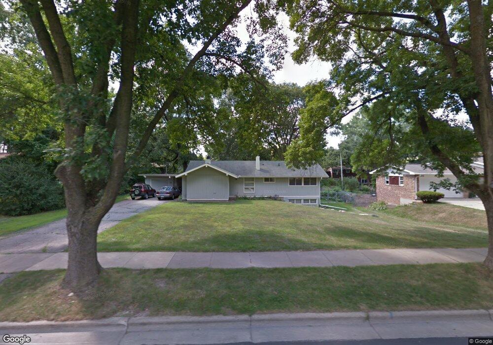
5405 Raymond Rd Madison, WI 53711
Meadowood NeighborhoodEstimated Value: $377,881 - $399,000
3
Beds
2
Baths
1,392
Sq Ft
$281/Sq Ft
Est. Value
About This Home
This home is located at 5405 Raymond Rd, Madison, WI 53711 and is currently estimated at $390,720, approximately $280 per square foot. 5405 Raymond Rd is a home located in Dane County with nearby schools including Orchard Ridge Elementary School, Toki Middle School, and Vel Phillips Memorial High School.
Ownership History
Date
Name
Owned For
Owner Type
Purchase Details
Closed on
May 23, 2005
Sold by
Theis Barbara M
Bought by
Lea Diane M
Current Estimated Value
Home Financials for this Owner
Home Financials are based on the most recent Mortgage that was taken out on this home.
Original Mortgage
$145,600
Outstanding Balance
$74,561
Interest Rate
6.07%
Mortgage Type
New Conventional
Estimated Equity
$316,159
Create a Home Valuation Report for This Property
The Home Valuation Report is an in-depth analysis detailing your home's value as well as a comparison with similar homes in the area
Home Values in the Area
Average Home Value in this Area
Purchase History
| Date | Buyer | Sale Price | Title Company |
|---|---|---|---|
| Lea Diane M | $182,000 | None Available |
Source: Public Records
Mortgage History
| Date | Status | Borrower | Loan Amount |
|---|---|---|---|
| Open | Lea Diane M | $145,600 |
Source: Public Records
Tax History
| Year | Tax Paid | Tax Assessment Tax Assessment Total Assessment is a certain percentage of the fair market value that is determined by local assessors to be the total taxable value of land and additions on the property. | Land | Improvement |
|---|---|---|---|---|
| 2024 | $12,523 | $335,400 | $105,100 | $230,300 |
| 2023 | $6,304 | $304,900 | $95,500 | $209,400 |
| 2022 | $9,967 | $269,800 | $84,500 | $185,300 |
| 2021 | $5,053 | $245,300 | $76,800 | $168,500 |
| 2020 | $4,760 | $224,000 | $70,100 | $153,900 |
| 2019 | $4,469 | $211,300 | $66,100 | $145,200 |
| 2018 | $4,182 | $197,500 | $61,800 | $135,700 |
| 2017 | $3,847 | $174,200 | $61,800 | $112,400 |
| 2016 | $3,685 | $162,800 | $61,800 | $101,000 |
| 2015 | $3,737 | $159,600 | $55,300 | $104,300 |
| 2014 | $3,657 | $159,600 | $55,300 | $104,300 |
| 2013 | $3,857 | $159,600 | $55,300 | $104,300 |
Source: Public Records
Map
Nearby Homes
- 5602 Raymond Rd
- 2102 Manor Green Dr
- 2309 Teal Dr
- 5314 Kroncke Dr
- 5710 Russett Rd
- 5704 Richmond Dr
- 1401 Lewon Dr
- 2609 Smithfield Dr
- 5837 Raymond Rd
- 6013 Raymond Rd
- 2567 Petersburg Cir
- 30 Whitcomb Cir Unit 10 D
- 14 Whitcomb Cir
- 1602 Redwood Ln
- 6305 Jacobs Way
- 6401 Raymond Rd
- 4514 Hammersley Rd Unit 2
- 6104 Davenport Dr
- 2502 Sara Rd
- 6310 Putnam Rd
- 5401 Raymond Rd
- 5409 Raymond Rd
- 5406 Denton Place
- 5402 Denton Place
- 5410 Denton Place
- 5313 Raymond Rd
- 2001 Gilbert Rd
- 5318 Denton Place
- 5414 Denton Place
- 5406 Raymond Rd
- 5410 Raymond Rd
- 5309 Raymond Rd
- 5402 Raymond Rd
- 5414 Raymond Rd
- 5314 Denton Place
- 2102 Aspen Rd
- 5310 Raymond Rd
- 2101 Aspen Rd
- 5409 Denton Place
- 1905 Gilbert Rd
Your Personal Tour Guide
Ask me questions while you tour the home.