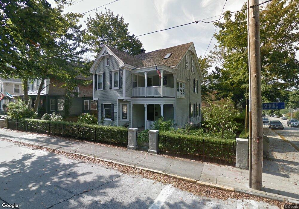
541 Spring St Newport, RI 02840
Fifth Ward NeighborhoodEstimated Value: $1,251,000 - $2,063,000
6
Beds
4
Baths
2,946
Sq Ft
$551/Sq Ft
Est. Value
About This Home
This home is located at 541 Spring St, Newport, RI 02840 and is currently estimated at $1,622,986, approximately $550 per square foot. 541 Spring St is a home located in Newport County with nearby schools including Rogers High School, St Michael's Country Day School, and All Saints STEAM Academy.
Ownership History
Date
Name
Owned For
Owner Type
Purchase Details
Closed on
Jan 1, 2025
Sold by
Hagerman John D and Hagerman Linda L
Bought by
Spray Trails Llc
Current Estimated Value
Purchase Details
Closed on
Jul 3, 2008
Sold by
Dunlap Jeannine and Benton Arthur
Bought by
Hagerman John and Hagerman Linda
Create a Home Valuation Report for This Property
The Home Valuation Report is an in-depth analysis detailing your home's value as well as a comparison with similar homes in the area
Home Values in the Area
Average Home Value in this Area
Purchase History
| Date | Buyer | Sale Price | Title Company |
|---|---|---|---|
| Spray Trails Llc | -- | None Available | |
| Hagerman John | $465,000 | -- | |
| Hagerman John | $465,000 | -- |
Source: Public Records
Mortgage History
| Date | Status | Borrower | Loan Amount |
|---|---|---|---|
| Previous Owner | Hagerman John | $256,849 | |
| Previous Owner | Hagerman John | $70,000 | |
| Previous Owner | Hagerman John | $18,000 |
Source: Public Records
Tax History Compared to Growth
Tax History
| Year | Tax Paid | Tax Assessment Tax Assessment Total Assessment is a certain percentage of the fair market value that is determined by local assessors to be the total taxable value of land and additions on the property. | Land | Improvement |
|---|---|---|---|---|
| 2025 | $10,789 | $1,241,700 | $555,300 | $686,400 |
| 2024 | $10,207 | $1,241,700 | $555,300 | $686,400 |
| 2023 | $8,146 | $821,200 | $365,600 | $455,600 |
| 2022 | $7,892 | $821,200 | $365,600 | $455,600 |
| 2021 | $7,662 | $821,200 | $365,600 | $455,600 |
| 2020 | $6,988 | $679,800 | $320,300 | $359,500 |
| 2019 | $6,988 | $679,800 | $320,300 | $359,500 |
| 2018 | $6,791 | $679,800 | $320,300 | $359,500 |
| 2017 | $6,134 | $547,200 | $246,400 | $300,800 |
| 2016 | $5,981 | $547,200 | $246,400 | $300,800 |
| 2015 | $5,839 | $547,200 | $246,400 | $300,800 |
| 2014 | $5,585 | $463,100 | $192,600 | $270,500 |
Source: Public Records
Map
Nearby Homes
- 66 Webster St Unit 9
- 604 Thames & 4 Dixon St
- 6 Sharon Ct
- 39 Connection St
- 13 Dean Ave
- 58 Connection St
- 364 Bellevue Ave Unit A1
- 364 Bellevue Ave Unit D7
- 26 Atlantic St
- 57 Clinton St Unit 57C
- 30 S Baptist St
- 91 Houston Ave
- 70 Carroll Ave Unit 510
- 8 Sylvan St
- 20 Berkeley Ave Unit 2
- 63 Coggeshall Ave
- 19 Slocum St
- 21 Slocum St
- 28 Young St
- 26 Freebody St
- 543 Spring St
- 545 Spring St
- 525 Spring St
- 32 Carey St
- 32 Carey St Unit 3A
- 32 Carey St Unit 3B
- 32 Carey St Unit 2B
- 32 Carey St Unit 2D
- 32 Carey St Unit 2C
- 32 Carey St Unit 2E
- 32 Carey St Unit 2A
- 32 Carey St Unit 1F
- 32 Carey St Unit 1D
- 32 Carey St Unit 1E
- 32 Carey St Unit 1C
- 32 Carey St Unit 1B
- 32 Carey St Unit 1A
- 36 Carey St
- 547 Spring St
- 547 Spring St Unit 1