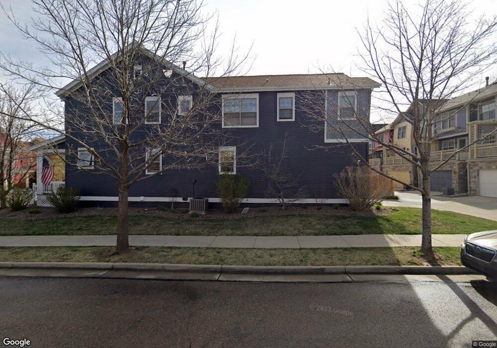
542 Homestead St Lafayette, CO 80026
Estimated Value: $785,143 - $1,108,000
4
Beds
4
Baths
3,637
Sq Ft
$239/Sq Ft
Est. Value
About This Home
This home is located at 542 Homestead St, Lafayette, CO 80026 and is currently estimated at $867,786, approximately $238 per square foot. 542 Homestead St is a home located in Boulder County with nearby schools including Lafayette Elementary School, Angevine Middle School, and Centaurus High School.
Ownership History
Date
Name
Owned For
Owner Type
Purchase Details
Closed on
Apr 18, 2014
Sold by
Wentworth Courtney R and Wentworth Bret A
Bought by
Garrison Jill
Current Estimated Value
Home Financials for this Owner
Home Financials are based on the most recent Mortgage that was taken out on this home.
Original Mortgage
$398,905
Outstanding Balance
$303,242
Interest Rate
4.34%
Mortgage Type
New Conventional
Estimated Equity
$564,544
Purchase Details
Closed on
May 3, 2006
Sold by
Annas Farm Llc
Bought by
Wentworth Bret A
Home Financials for this Owner
Home Financials are based on the most recent Mortgage that was taken out on this home.
Original Mortgage
$280,610
Interest Rate
6.32%
Mortgage Type
Fannie Mae Freddie Mac
Create a Home Valuation Report for This Property
The Home Valuation Report is an in-depth analysis detailing your home's value as well as a comparison with similar homes in the area
Home Values in the Area
Average Home Value in this Area
Purchase History
| Date | Buyer | Sale Price | Title Company |
|---|---|---|---|
| Garrison Jill | $419,900 | Land Title Guarantee Company | |
| Wentworth Bret A | $350,763 | Land Title Guarantee Company |
Source: Public Records
Mortgage History
| Date | Status | Borrower | Loan Amount |
|---|---|---|---|
| Open | Garrison Jill | $398,905 | |
| Previous Owner | Wentworth Bret A | $280,610 |
Source: Public Records
Tax History Compared to Growth
Tax History
| Year | Tax Paid | Tax Assessment Tax Assessment Total Assessment is a certain percentage of the fair market value that is determined by local assessors to be the total taxable value of land and additions on the property. | Land | Improvement |
|---|---|---|---|---|
| 2025 | $4,523 | $52,469 | $11,181 | $41,288 |
| 2024 | $4,523 | $52,469 | $11,181 | $41,288 |
| 2023 | $4,445 | $51,041 | $12,362 | $42,364 |
| 2022 | $4,048 | $43,090 | $9,271 | $33,819 |
| 2021 | $4,003 | $44,330 | $9,538 | $34,792 |
| 2020 | $3,595 | $39,339 | $8,294 | $31,045 |
| 2019 | $3,546 | $39,339 | $8,294 | $31,045 |
| 2018 | $3,486 | $38,182 | $9,144 | $29,038 |
| 2017 | $3,394 | $42,212 | $10,109 | $32,103 |
| 2016 | $3,118 | $33,966 | $8,438 | $25,528 |
| 2015 | $2,922 | $27,804 | $9,313 | $18,491 |
| 2014 | $2,404 | $27,804 | $9,313 | $18,491 |
Source: Public Records
Map
Nearby Homes
- 1376 Lambert Cir
- 736 Gateway Cir
- 1160 Devonshire Ct
- 1140 Devonshire Ct
- 926 Hearteye Trail
- 535 Sawtooth Point
- 925 Latigo Loop
- 411 Levi Ln
- 2-Story Alley Load Duplex - Butterfly Plan at Silver Creek
- 1125 Somerset St
- 1650 Benjamin Ln
- 2005 Aster Ln
- 1140 Dorset Ct
- 2086 Navajo Trail
- 82 Goldhill Dr
- 121 Rowena Place
- 2079 N Fork Dr
- 200 S Carr Ave
- 0 Rainbow Ln
- 2247 Eagles Nest Dr
- 538 Homestead St
- 546 Homestead St
- 516 Homestead St
- 534 Homestead St
- 518 Homestead St
- 520 Homestead St
- 550 Homestead St
- 522 Homestead St
- 530 Homestead St
- 554 Homestead St
- 524 Homestead St
- 558 Homestead St
- 526 Homestead St
- 562 Homestead St
- 592 Homestead St
- 588 Homestead St
- 412 Homestead St
- 584 Homestead St
- 525 Homestead St
- 527 Homestead St