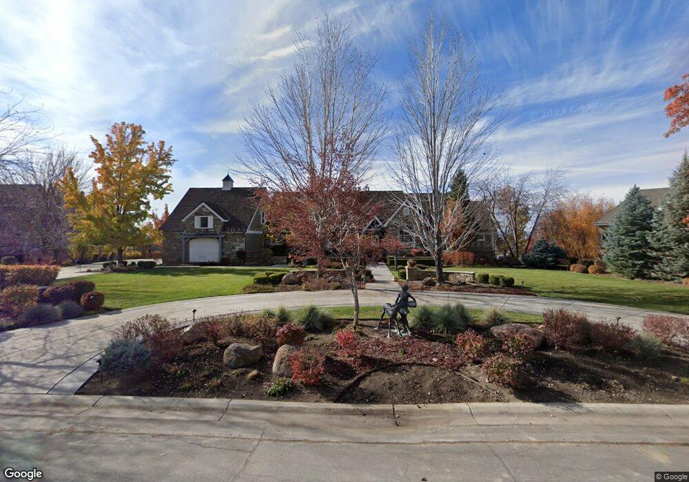
542 S Eagle Dr Mapleton, UT 84664
Estimated Value: $2,134,403 - $2,172,000
3
Beds
6
Baths
3,810
Sq Ft
$565/Sq Ft
Est. Value
About This Home
This home is located at 542 S Eagle Dr, Mapleton, UT 84664 and is currently estimated at $2,153,202, approximately $565 per square foot. 542 S Eagle Dr is a home located in Utah County with nearby schools including Mapleton School, Mapleton Junior High School, and Maple Mountain High School.
Ownership History
Date
Name
Owned For
Owner Type
Purchase Details
Closed on
Nov 15, 2006
Sold by
Nellesen Keith
Bought by
Nellesen Keith and Nellesen Melisa
Current Estimated Value
Purchase Details
Closed on
Aug 16, 2004
Sold by
Maliwauki Mark C and Maliwaukie Cynthia Lee
Bought by
Nellesen Keith
Purchase Details
Closed on
Jun 2, 2000
Sold by
Bankhead Lewis and Bankhead Thomas
Bought by
Maliwauki Mark C and Maliwauki Cynthia Lee
Home Financials for this Owner
Home Financials are based on the most recent Mortgage that was taken out on this home.
Original Mortgage
$540,000
Interest Rate
8.18%
Mortgage Type
Construction
Create a Home Valuation Report for This Property
The Home Valuation Report is an in-depth analysis detailing your home's value as well as a comparison with similar homes in the area
Home Values in the Area
Average Home Value in this Area
Purchase History
| Date | Buyer | Sale Price | Title Company |
|---|---|---|---|
| Nellesen Keith | -- | Lone Peak Title | |
| Nellesen Keith | -- | First American Title Agency | |
| Maliwauki Mark C | -- | Signature Title |
Source: Public Records
Mortgage History
| Date | Status | Borrower | Loan Amount |
|---|---|---|---|
| Previous Owner | Maliwauki Mark C | $540,000 |
Source: Public Records
Tax History
| Year | Tax Paid | Tax Assessment Tax Assessment Total Assessment is a certain percentage of the fair market value that is determined by local assessors to be the total taxable value of land and additions on the property. | Land | Improvement |
|---|---|---|---|---|
| 2025 | $9,733 | $1,044,380 | -- | -- |
| 2024 | $9,733 | $953,485 | $0 | $0 |
| 2023 | $10,442 | $1,029,330 | $0 | $0 |
| 2022 | $12,471 | $2,206,900 | $597,900 | $1,609,000 |
| 2021 | $10,454 | $1,561,900 | $324,200 | $1,237,700 |
| 2020 | $10,329 | $1,492,900 | $302,800 | $1,190,100 |
| 2019 | $9,984 | $1,472,900 | $282,800 | $1,190,100 |
| 2018 | $9,775 | $1,373,100 | $272,300 | $1,100,800 |
| 2017 | $9,907 | $739,540 | $0 | $0 |
| 2016 | $8,899 | $660,360 | $0 | $0 |
| 2015 | $8,194 | $604,370 | $0 | $0 |
| 2014 | $7,865 | $569,715 | $0 | $0 |
Source: Public Records
Map
Nearby Homes
- 644 S 1330 E
- 4021 S Ironwood Ln Unit 428
- 4886 S Englemann Ln Unit 525
- 2254 715 S Unit 60
- 4013 S Ironwood Ln Unit 432
- 4014 S Ironwood Ln
- 4001 S Ironwood Ln Unit 438
- 2254 715 S
- 4012 S Ironwood Ln Unit 424
- 2042 715 S Unit 57
- 4019 S Ironwood Ln Unit 429
- 2042 715 S
- 1759 S Perry Dr
- 575 S 1560 E
- 1377 E Maple St
- 753 Sierra View Dr
- 1515 E Maple St
- 748 Sierra View Dr
- 234 S Krissa St Unit 1
- 266 S Krissa St Unit 2
- 510 S Eagle Dr
- 578 S Eagle Dr
- 2650 715 S
- 4016 S Ironwood Ln Unit 426
- 3823 S Powerwood Ln Unit 219
- 2223 715 S Unit 62
- 2188 715 S Unit 59
- 710 715 S
- 710 715 S Unit J201
- 710 715 S Unit M201
- 774 715 S Unit 204
- 1254 Dogwood Dr
- 572 S 1200 E
- 634 S 1200 E
- 1340 E Dogwood Dr E
- 1355 E 400 S Unit 4
- 208 E 400 S
- 1345 E 400 S
- 1345 E Dogwood Dr
- 1091 Hawks Rest Dr
Your Personal Tour Guide
Ask me questions while you tour the home.