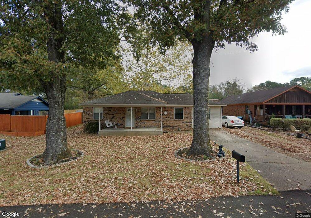
5426 Arlin Dr Arlington, TN 38002
Estimated Value: $132,000 - $241,000
4
Beds
2
Baths
1,211
Sq Ft
$164/Sq Ft
Est. Value
About This Home
This home is located at 5426 Arlin Dr, Arlington, TN 38002 and is currently estimated at $198,484, approximately $163 per square foot. 5426 Arlin Dr is a home located in Shelby County with nearby schools including Donelson Elementary School, Arlington Middle School, and Arlington High School.
Ownership History
Date
Name
Owned For
Owner Type
Purchase Details
Closed on
Nov 27, 2002
Sold by
Mackus Samantha and Mcculley Samantha
Bought by
Knight John Terry and Knight Christy Ann
Current Estimated Value
Home Financials for this Owner
Home Financials are based on the most recent Mortgage that was taken out on this home.
Original Mortgage
$44,000
Interest Rate
6.08%
Purchase Details
Closed on
Apr 1, 1998
Sold by
Mcculley Michael
Bought by
Mcculley Samantha
Purchase Details
Closed on
Apr 25, 1997
Sold by
Wiseman Albert and Wiseman Becky
Bought by
Mcculley Michael and Mcculley Samantha
Home Financials for this Owner
Home Financials are based on the most recent Mortgage that was taken out on this home.
Original Mortgage
$54,000
Interest Rate
9%
Create a Home Valuation Report for This Property
The Home Valuation Report is an in-depth analysis detailing your home's value as well as a comparison with similar homes in the area
Home Values in the Area
Average Home Value in this Area
Purchase History
| Date | Buyer | Sale Price | Title Company |
|---|---|---|---|
| Knight John Terry | $88,000 | Fayette County Title Company | |
| Mcculley Samantha | -- | Memphis Title | |
| Mcculley Michael | $55,000 | -- |
Source: Public Records
Mortgage History
| Date | Status | Borrower | Loan Amount |
|---|---|---|---|
| Closed | Knight John Terry | $44,000 | |
| Previous Owner | Mcculley Michael | $54,000 |
Source: Public Records
Tax History Compared to Growth
Tax History
| Year | Tax Paid | Tax Assessment Tax Assessment Total Assessment is a certain percentage of the fair market value that is determined by local assessors to be the total taxable value of land and additions on the property. | Land | Improvement |
|---|---|---|---|---|
| 2025 | $1,044 | $34,425 | $6,900 | $27,525 |
| 2024 | $2,088 | $30,800 | $6,650 | $24,150 |
| 2023 | $1,438 | $30,800 | $6,650 | $24,150 |
| 2022 | $1,438 | $30,800 | $6,650 | $24,150 |
| 2021 | $1,457 | $30,800 | $6,650 | $24,150 |
| 2020 | $1,217 | $22,450 | $6,650 | $15,800 |
| 2019 | $909 | $22,450 | $6,650 | $15,800 |
| 2018 | $1,167 | $22,450 | $6,650 | $15,800 |
| 2017 | $1,181 | $22,450 | $6,650 | $15,800 |
| 2016 | $1,056 | $19,125 | $0 | $0 |
| 2014 | $836 | $19,125 | $0 | $0 |
Source: Public Records
Map
Nearby Homes
- 5432 Hidden Meadows Dr
- 11165 Black Sheep Dr
- 5282 Hidden Meadows Dr
- 5710 Ardsley Dr E
- 11283 Ardsley Dr N
- 5146 Shetland Trail
- Amelia Plan at Myers Park
- Manning Plan at Myers Park
- Kensley Plan at Myers Park
- Harper Plan at Myers Park
- Anniston Plan at Myers Park
- Chapman Plan at Myers Park
- Hudson Plan at Myers Park
- Asher Plan at Myers Park
- Glenmore Plan at Myers Park
- Sloan Plan at Myers Park
- Chelsea Plan at Myers Park
- 11311 Ardsley Dr S
- 5652 Gerber Rd
- 5624 Draper Trail
- 5432 Arlin Dr
- 5422 Arlin Dr
- 5438 Arlin Dr
- 11056 Bonnie Creek Cove
- 5429 Arlin Dr
- 5417 Arlin Dr
- 5437 Arlin Dr
- 5423 Arlin Dr
- 5448 Arlin Dr
- 11064 Bonnie Creek Cove
- 5411 Arlin Dr
- 5447 Arlin Dr
- 5405 Arlin Dr
- 5456 Arlin Dr
- 11069 Bonnie Creek Cove
- 5459 Arlin Dr
- 5399 Arlin Dr
- 11059 Bonnie Creek Cove
- 11065 Bonnie Creek Cove
- 10979 U S 70