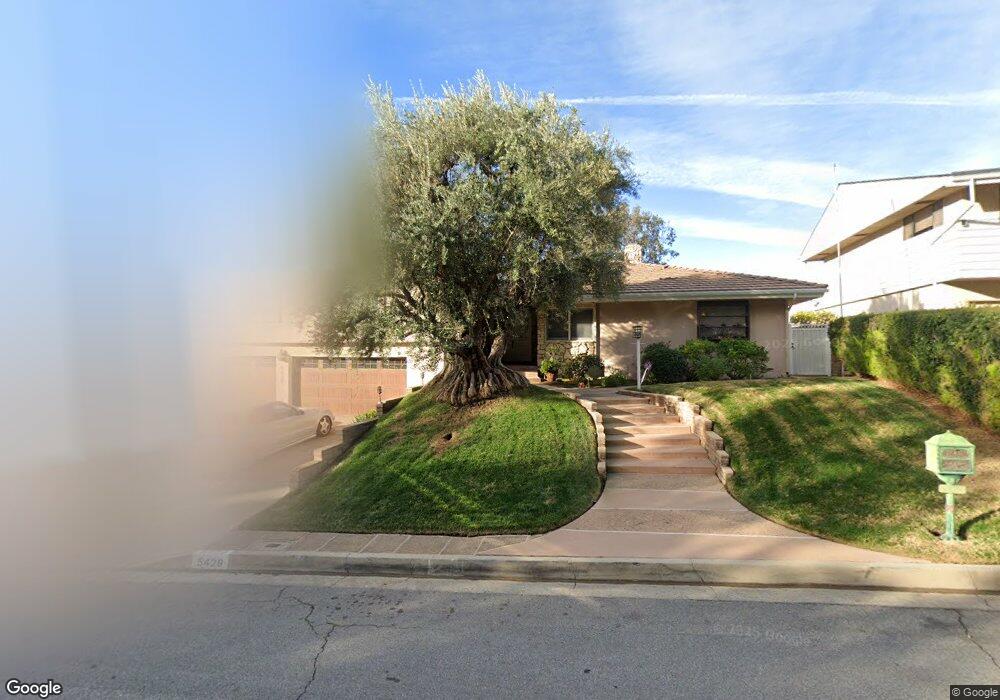
5429 Burning Tree Dr La Canada Flintridge, CA 91011
Estimated Value: $2,886,662 - $3,362,000
5
Beds
3
Baths
3,734
Sq Ft
$828/Sq Ft
Est. Value
About This Home
This home is located at 5429 Burning Tree Dr, La Canada Flintridge, CA 91011 and is currently estimated at $3,091,666, approximately $827 per square foot. 5429 Burning Tree Dr is a home located in Los Angeles County with nearby schools including Paradise Canyon Elementary School, La Canada High School, and La Canada Preparatory School.
Ownership History
Date
Name
Owned For
Owner Type
Purchase Details
Closed on
Jun 30, 1995
Sold by
Smullen Jo Ann and Smullen Richard R
Bought by
Friedman Julius and Friedman Pamalyn P
Current Estimated Value
Home Financials for this Owner
Home Financials are based on the most recent Mortgage that was taken out on this home.
Original Mortgage
$300,000
Interest Rate
7.63%
Create a Home Valuation Report for This Property
The Home Valuation Report is an in-depth analysis detailing your home's value as well as a comparison with similar homes in the area
Home Values in the Area
Average Home Value in this Area
Purchase History
| Date | Buyer | Sale Price | Title Company |
|---|---|---|---|
| Friedman Julius | $700,000 | Southland Title Corporation |
Source: Public Records
Mortgage History
| Date | Status | Borrower | Loan Amount |
|---|---|---|---|
| Previous Owner | Friedman Julius | $300,000 |
Source: Public Records
Tax History
| Year | Tax Paid | Tax Assessment Tax Assessment Total Assessment is a certain percentage of the fair market value that is determined by local assessors to be the total taxable value of land and additions on the property. | Land | Improvement |
|---|---|---|---|---|
| 2025 | $13,568 | $1,162,874 | $376,101 | $786,773 |
| 2024 | $13,568 | $1,140,074 | $368,727 | $771,347 |
| 2023 | $13,243 | $1,117,721 | $361,498 | $756,223 |
| 2022 | $12,719 | $1,095,806 | $354,410 | $741,396 |
| 2021 | $12,611 | $1,074,320 | $347,461 | $726,859 |
| 2019 | $12,234 | $1,042,456 | $337,156 | $705,300 |
| 2018 | $11,902 | $1,022,017 | $330,546 | $691,471 |
| 2016 | $11,557 | $982,332 | $317,711 | $664,621 |
| 2015 | $11,503 | $967,577 | $312,939 | $654,638 |
| 2014 | $11,350 | $948,624 | $306,809 | $641,815 |
Source: Public Records
Map
Nearby Homes
- 411 Meadowview Dr
- 494 Paulette Place
- 752 Galaxy Heights Dr
- 340 Santa Inez Way
- 767 Starlight Heights Dr
- 5065 Indianola Way
- 358 San Juan Way
- 832 Greenridge Dr
- 5748 Briartree Dr
- 4487 Rising Hill Rd
- 3740 Canyon Crest Rd
- 820 Millard Canyon Rd
- 752 Via Arezzo Place
- 746 Via Arezzo Place
- 4938 Angeles Crest Hwy
- 4428 Oakwood Ave
- 941 Chehalem Rd
- 740 Via Arezzo Place
- 3903 Lilac Canyon Ln
- 3751 N Hollingsworth Rd
- 5435 Burning Tree Dr
- 5421 Burning Tree Dr
- 451 Meadowview Dr
- 5441 Burning Tree Dr
- 5415 Burning Tree Dr
- 5451 Burning Tree Dr
- 476 Starlight Crest Dr
- 470 Starlight Crest Dr
- 466 Starlight Crest Dr
- 5455 Burning Tree Dr
- 450 Meadowview Dr
- 490 Starlight Crest Dr
- 425 Meadowview Dr
- 444 Meadowview Dr
- 5467 Burning Tree Dr
- 494 Starlight Crest Dr
- 440 Meadowview Dr
- 401 Meadowview Dr
- 5475 Burning Tree Dr
- 434 Meadowview Dr
Your Personal Tour Guide
Ask me questions while you tour the home.