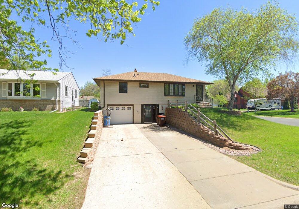
543 13th Ave S South Saint Paul, MN 55075
Estimated Value: $293,000 - $331,119
3
Beds
2
Baths
1,617
Sq Ft
$194/Sq Ft
Est. Value
About This Home
This home is located at 543 13th Ave S, South Saint Paul, MN 55075 and is currently estimated at $314,280, approximately $194 per square foot. 543 13th Ave S is a home located in Dakota County with nearby schools including Kaposia Education Center Elementary, South St. Paul Middle School, and South St. Paul Secondary.
Ownership History
Date
Name
Owned For
Owner Type
Purchase Details
Closed on
Jul 15, 2022
Sold by
Murphy Timothy and Murphy Theresa
Bought by
Burns Dennis and Burns Kathleen
Current Estimated Value
Home Financials for this Owner
Home Financials are based on the most recent Mortgage that was taken out on this home.
Original Mortgage
$121,582
Outstanding Balance
$115,503
Interest Rate
5.09%
Mortgage Type
New Conventional
Estimated Equity
$198,777
Create a Home Valuation Report for This Property
The Home Valuation Report is an in-depth analysis detailing your home's value as well as a comparison with similar homes in the area
Home Values in the Area
Average Home Value in this Area
Purchase History
| Date | Buyer | Sale Price | Title Company |
|---|---|---|---|
| Burns Dennis | $330,500 | -- |
Source: Public Records
Mortgage History
| Date | Status | Borrower | Loan Amount |
|---|---|---|---|
| Open | Burns Dennis | $121,582 |
Source: Public Records
Tax History Compared to Growth
Tax History
| Year | Tax Paid | Tax Assessment Tax Assessment Total Assessment is a certain percentage of the fair market value that is determined by local assessors to be the total taxable value of land and additions on the property. | Land | Improvement |
|---|---|---|---|---|
| 2024 | $3,356 | $235,200 | $68,500 | $166,700 |
| 2023 | $3,356 | $239,800 | $68,900 | $170,900 |
| 2022 | $2,604 | $230,000 | $68,800 | $161,200 |
| 2021 | $2,430 | $203,500 | $59,900 | $143,600 |
| 2020 | $2,370 | $188,600 | $57,000 | $131,600 |
| 2019 | $2,117 | $188,600 | $54,300 | $134,300 |
| 2018 | $2,063 | $165,300 | $49,400 | $115,900 |
| 2017 | $1,838 | $155,900 | $47,000 | $108,900 |
| 2016 | $1,923 | $145,100 | $42,800 | $102,300 |
| 2015 | $1,827 | $120,810 | $33,910 | $86,900 |
| 2014 | -- | $121,791 | $33,975 | $87,816 |
| 2013 | -- | $105,877 | $28,868 | $77,009 |
Source: Public Records
Map
Nearby Homes
- 456 10th Ave S
- 450 10th Ave S
- 354 12th Ave S
- 4614 Bloomberg Ln
- 4852 Bisset Ln Unit 9504
- 308 10th Ave S
- 804 8th Ave S
- 4745 Blaine Ave Unit 509
- 4552 Blaylock Way
- 4611 Blaine Ave Unit 1308
- 548 5th Ave S
- 140 12th Ave S
- 137 9th Ave S
- 210 19th Ave S
- 348 4th Ave S
- 636 3rd Ave S
- 118 9th Ave S
- 101 11th Ave N
- 535 3rd Ave S
- 118 11th Ave N
- 537 13th Ave S
- 531 13th Ave S
- 542 12th Ave S
- 531 531 13th Ave S
- 536 12th Ave S
- 2778 46th St E
- 2760 46th St E
- 530 12th Ave S
- 525 13th Ave S
- 542 13th Ave S
- 1 Apfelridge Ct
- 2796 46th St E
- 536 13th Ave S
- 524 12th Ave S
- 530 13th Ave S
- 519 13th Ave S
- 530 530 12th-Avenue-s
- 519 519 13th Ave S
- 524 13th Ave S
- 518 12th Ave S