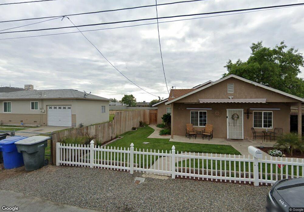
543 Kimball Ln Hanford, CA 93230
Estimated Value: $278,258 - $331,000
3
Beds
2
Baths
1,515
Sq Ft
$204/Sq Ft
Est. Value
About This Home
This home is located at 543 Kimball Ln, Hanford, CA 93230 and is currently estimated at $308,565, approximately $203 per square foot. 543 Kimball Ln is a home located in Kings County with nearby schools including Roosevelt Elementary School, Woodrow Wilson Junior High School, and Hanford West High School.
Ownership History
Date
Name
Owned For
Owner Type
Purchase Details
Closed on
Dec 25, 2010
Sold by
Chapa Perez Richard and Chapa Perez Ofelia
Bought by
Chapa Perez Richard and Chapa Perez Ofelia
Current Estimated Value
Home Financials for this Owner
Home Financials are based on the most recent Mortgage that was taken out on this home.
Original Mortgage
$84,000
Outstanding Balance
$2,520
Interest Rate
4.34%
Mortgage Type
New Conventional
Estimated Equity
$306,045
Purchase Details
Closed on
Nov 30, 2006
Sold by
Chapa Antonio Garza and Chapa Catalina
Bought by
Chapa Perez Richard and Chapa Perez Ofelia
Create a Home Valuation Report for This Property
The Home Valuation Report is an in-depth analysis detailing your home's value as well as a comparison with similar homes in the area
Home Values in the Area
Average Home Value in this Area
Purchase History
| Date | Buyer | Sale Price | Title Company |
|---|---|---|---|
| Chapa Perez Richard | -- | Chicago Title | |
| Chapa Perez Richard | -- | None Available |
Source: Public Records
Mortgage History
| Date | Status | Borrower | Loan Amount |
|---|---|---|---|
| Open | Chapa Perez Richard | $84,000 |
Source: Public Records
Tax History Compared to Growth
Tax History
| Year | Tax Paid | Tax Assessment Tax Assessment Total Assessment is a certain percentage of the fair market value that is determined by local assessors to be the total taxable value of land and additions on the property. | Land | Improvement |
|---|---|---|---|---|
| 2025 | $943 | $88,847 | $5,883 | $82,964 |
| 2023 | $943 | $85,399 | $5,655 | $79,744 |
| 2022 | $1,043 | $83,726 | $5,545 | $78,181 |
| 2021 | $1,023 | $82,086 | $5,437 | $76,649 |
| 2020 | $1,033 | $81,244 | $5,381 | $75,863 |
| 2019 | $1,017 | $79,650 | $5,275 | $74,375 |
| 2018 | $992 | $78,089 | $5,172 | $72,917 |
| 2017 | $979 | $76,558 | $5,071 | $71,487 |
| 2016 | $967 | $75,057 | $4,972 | $70,085 |
| 2015 | $962 | $73,929 | $4,897 | $69,032 |
| 2014 | $945 | $72,481 | $4,801 | $67,680 |
Source: Public Records
Map
Nearby Homes
- 626 Kimball Ln
- 573 Manor Ave
- 670 Grant St
- 735 Manor Ave
- 1240 Washington St
- 165 Walnut St
- 152 Walnut St
- 148 Walnut St
- 650 S 11th Ave
- 558 Parsons St
- 1405 Arthur St
- 930 W 7th St
- 1121 W 6th St
- 942 W 7th St
- 1526 W Bison Ln Unit Ae 86
- 1575 Bluejay Cir
- 604 S Phillips St
- 400 Scott St
- 307 W 3rd St
- 222 1/2 W 2nd St
- 551 Kimball Ln
- 531 Kimball Ln
- 559 Kimball Ln
- 1104 Sansome St
- 571 Kimball Ln
- 1109 Sansome St
- 518 Kimball Ln
- 504 Kimball Ln
- 566 Kimball Ln
- 1152 Sansome St
- 1094 Davis St
- 1082 Davis St
- 1070 Davis St
- 558 Garland Way
- 1155 Sansome St
- 1125 Lombard St
- 566 Garland Way
- 550 Garland Way
- 1168 Sansome St
- 1106 Davis St