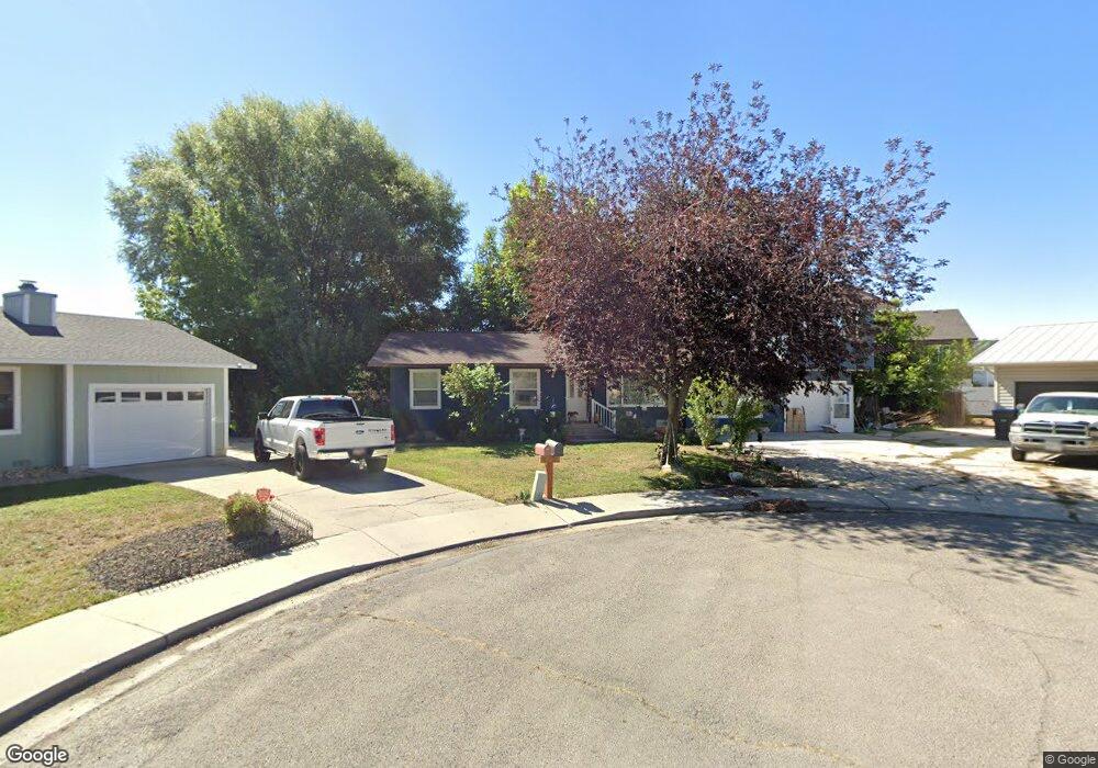
543 W 1770 S Provo, UT 84601
Franklin NeighborhoodEstimated Value: $460,000 - $543,000
3
Beds
2
Baths
2,113
Sq Ft
$239/Sq Ft
Est. Value
About This Home
This home is located at 543 W 1770 S, Provo, UT 84601 and is currently estimated at $504,620, approximately $238 per square foot. 543 W 1770 S is a home located in Utah County with nearby schools including Franklin Elementary School, Dixon Middle School, and Provo High School.
Ownership History
Date
Name
Owned For
Owner Type
Purchase Details
Closed on
Jan 6, 1999
Sold by
Montecinos Amanda B and Kimball Kirk David
Bought by
Montecinos Amanda B
Current Estimated Value
Purchase Details
Closed on
Dec 19, 1997
Sold by
Cloward James and Cloward Eileen Z
Bought by
Montecinos Amanda B and Kimball Kirk David
Home Financials for this Owner
Home Financials are based on the most recent Mortgage that was taken out on this home.
Original Mortgage
$109,346
Outstanding Balance
$18,499
Interest Rate
7.23%
Mortgage Type
FHA
Estimated Equity
$486,121
Create a Home Valuation Report for This Property
The Home Valuation Report is an in-depth analysis detailing your home's value as well as a comparison with similar homes in the area
Home Values in the Area
Average Home Value in this Area
Purchase History
| Date | Buyer | Sale Price | Title Company |
|---|---|---|---|
| Montecinos Amanda B | -- | First American Title Co | |
| Montecinos Amanda B | -- | -- |
Source: Public Records
Mortgage History
| Date | Status | Borrower | Loan Amount |
|---|---|---|---|
| Open | Montecinos Amanda B | $109,346 |
Source: Public Records
Tax History Compared to Growth
Tax History
| Year | Tax Paid | Tax Assessment Tax Assessment Total Assessment is a certain percentage of the fair market value that is determined by local assessors to be the total taxable value of land and additions on the property. | Land | Improvement |
|---|---|---|---|---|
| 2025 | $2,407 | $249,810 | $181,800 | $272,400 |
| 2024 | $2,407 | $236,885 | $0 | $0 |
| 2023 | $2,345 | $227,535 | $0 | $0 |
| 2022 | $2,460 | $240,680 | $0 | $0 |
| 2021 | $1,909 | $325,700 | $99,800 | $225,900 |
| 2020 | $1,851 | $296,100 | $90,700 | $205,400 |
| 2019 | $1,378 | $285,700 | $90,700 | $195,000 |
| 2018 | $1,549 | $261,400 | $83,100 | $178,300 |
| 2017 | $1,323 | $122,650 | $0 | $0 |
| 2016 | $1,271 | $109,835 | $0 | $0 |
| 2015 | $1,177 | $102,795 | $0 | $0 |
| 2014 | $1,056 | $96,140 | $0 | $0 |
Source: Public Records
Map
Nearby Homes
- 588 W 1720 S
- 642 W 1870 S Unit 1046
- 1895 S 530 W Unit 1191
- 661 W 1920 S Unit 1072
- Oakridge (Crawl) Plan at Osprey Towns
- 686 W 1920 S Unit 1024
- Dalton Plan at Osprey Towns
- Dumont Plan at Osprey Towns
- Millbrook (Crawl) Plan at Osprey Towns
- 311 W 1610 S
- 655 W 1280 S
- 1095 S 500 W Unit 11
- 985 S 600 W
- 272 W 1020 S Unit B
- 914 W 1150 S Unit 2
- 908 W 1150 S Unit 3
- 966 S Freedom Blvd Unit 1
- 933 S Blvd W
- 131 S Meadow Dr Unit 20
- 169 S Meadow Dr Unit 18
- 515 W 1770 S
- 1795 S 570 W
- 1777 S 570 W Unit 111
- 538 W 1820 S
- 540 W 1770 S
- 510 W 1820 S
- 1813 S 570 W Unit LOT113
- 512 W 1770 S
- 1755 S 570 W
- 549 W 1720 S
- 494 Lakewood Dr
- 1765 S 500 W
- 521 W 1720 S
- 1792 S 570 W Unit LOT118
- 1774 S 570 W Unit 119
- 541 W 1820 S
- 1810 S 570 W Unit 117
- 1810 S 570 W
- 563 W 1820 S
- 1735 S 500 W