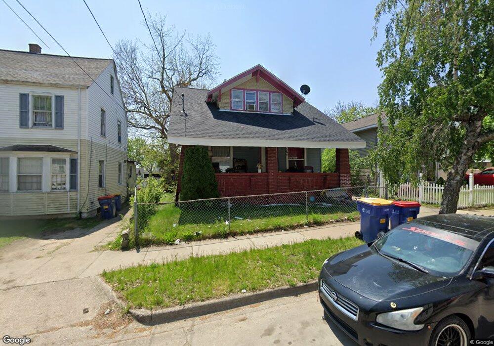
544 Shamrock St SW Grand Rapids, MI 49503
Roosevelt Park NeighborhoodEstimated Value: $166,000 - $205,000
3
Beds
1
Bath
1,132
Sq Ft
$165/Sq Ft
Est. Value
About This Home
This home is located at 544 Shamrock St SW, Grand Rapids, MI 49503 and is currently estimated at $187,145, approximately $165 per square foot. 544 Shamrock St SW is a home located in Kent County with nearby schools including Cesar E. Chavez Elementary, Burton Middle School, and Union High School.
Ownership History
Date
Name
Owned For
Owner Type
Purchase Details
Closed on
Oct 26, 2011
Sold by
Secretary Of Housing & Urban Development
Bought by
Bernabe Gaspar
Current Estimated Value
Purchase Details
Closed on
Aug 4, 2011
Sold by
The Huntington National Bank
Bought by
The Secretary Of Housing & Urban Develop
Purchase Details
Closed on
Jan 26, 2011
Sold by
Moreno Garcia Gustavo and Jimenez Ana Marie
Bought by
The Huntington National Bank
Purchase Details
Closed on
Jan 2, 2008
Sold by
Garcia Gustavo Moreno
Bought by
Vazquez Humberto Alejandro Zavala and Silva Elvia Zavala
Create a Home Valuation Report for This Property
The Home Valuation Report is an in-depth analysis detailing your home's value as well as a comparison with similar homes in the area
Home Values in the Area
Average Home Value in this Area
Purchase History
| Date | Buyer | Sale Price | Title Company |
|---|---|---|---|
| Bernabe Gaspar | $14,000 | None Available | |
| The Secretary Of Housing & Urban Develop | -- | None Available | |
| The Huntington National Bank | $87,143 | None Available | |
| Vazquez Humberto Alejandro Zavala | -- | None Available |
Source: Public Records
Tax History Compared to Growth
Tax History
| Year | Tax Paid | Tax Assessment Tax Assessment Total Assessment is a certain percentage of the fair market value that is determined by local assessors to be the total taxable value of land and additions on the property. | Land | Improvement |
|---|---|---|---|---|
| 2025 | $1,142 | $85,500 | $0 | $0 |
| 2024 | $1,142 | $66,300 | $0 | $0 |
| 2023 | $1,530 | $61,500 | $0 | $0 |
| 2022 | $1,077 | $52,400 | $0 | $0 |
| 2021 | $1,049 | $43,800 | $0 | $0 |
| 2020 | $1,110 | $36,300 | $0 | $0 |
| 2019 | $1,038 | $30,900 | $0 | $0 |
| 2018 | $1,006 | $26,400 | $0 | $0 |
| 2017 | $2,040 | $19,500 | $0 | $0 |
| 2016 | $1,047 | $18,600 | $0 | $0 |
| 2015 | $940 | $18,600 | $0 | $0 |
| 2013 | -- | $19,700 | $0 | $0 |
Source: Public Records
Map
Nearby Homes
- 721 Olympia St SW
- 730 Liberty St SW
- 719 Coate Ct SW
- 754 Olympia St SW
- 358 Fox St SW
- 543 Tenhaaf Ct SW
- 343 Corinne St SW
- 125 Hall St SW
- 1018 Norwich Ave SW
- 1265 Ionia Ave SW
- 877 Oakland Ave SW
- 847 Sheridan Ave SW
- 362 Fox St SW
- 325 Brown St SW
- 1805 Stafford Ave SW
- 34 La Belle St SE
- 46 Dickinson St SW
- 100 Griggs St SW
- 1149 Jefferson Ave SE
- 1335 Jefferson Ave SE
- 548 Shamrock St SW
- 540 Shamrock St SW
- 552 Shamrock St SW
- 536 Shamrock St SW
- 535 Liberty St SW
- 558 Shamrock St SW
- 539 Liberty St SW
- 532 Shamrock St SW
- 531 Liberty St SW
- 545 Liberty St SW
- 527 Liberty St SW
- 560 Shamrock St SW
- 545 Shamrock St SW
- 528 Shamrock St SW
- 551 Shamrock St SW
- 543 Shamrock St SW
- 519 Liberty St SW
- 553 Shamrock St SW
- 553 Shamrock St SW Unit 2
- 559 Liberty St SW